Ok, I have not commented as I read and processed all of this. If it is okay I would like to just sum up the topic so that when another me (Inexperienced and new to this) comes along, they can get a quick end workflow. I also have to write up a workflow sheet for others so this should help.
Please correct me if anything is wrong.
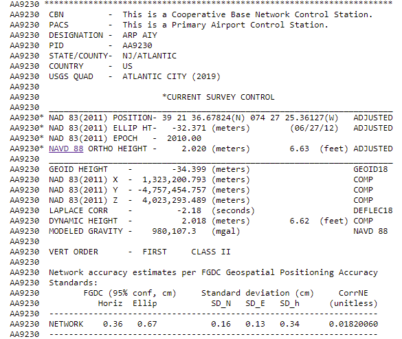
RTK Workflow for known Points in NAD83(2011) Using Reachview 2 and then Reachview 3 using Datasheet below
Reachview 2 Workflow
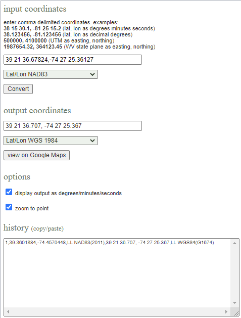
Reachview 2 works in WGS84 so I must convert my NAD83(2011) coordinates to WGS84 using below conversion link https://tagis.dep.wv.gov/convert/
I now can use the decimal degrees 39.3601884, -74.4570448 (obtained from the conversion from NAD83(2011) to WGS1984 and the -32.371 Ellipsoid ht (Obtained from the Datasheet under NAD83(2011) Ellip HT) and place these in the Manual Coordinates section of my Reach RS Base.
The italics is where I am stuck. Since the coordinates were converted to WGS84, did they shift and therefore shift on the ellipsoid and now the elevation is wrong? I have read that the WGS84 and NAD83(GRS 1980) are for my intents the same, but if my coordinates shifted horizontally, did this now place them shifted on the ellipsoid.
This thread was great reading but I am still not sure of Reachview 2 vs Reachview 3 as the post marked as solution is definitely for Reachview 3.
As such I guess I will only use Reachview 3 for now on as it will meet my needs.
I’ve yet to even use my Baam Tech PPK kit on my drone as that will add some more questions most likely in what datum it wants the base in. Its directions are very basic.
So for my Reachview 3 Workflow.
Place my RS2 Base over the monument (Datasheet) above
In my RS2 Base in Manual I enter: 39 21 36.67824 , -74 27 25.36127 (After converted to decimal degrees) and then the NAD83(GRS80) Ellipsoid at -32.371
Set my antenna height to include pole length and .134 m for the RS2 Unit
Then in my RS+ Rover I start a new Survey Project and then choose:
EPSG: 6318 NAD83(2011) for Coordinates
EPSG: 5703 NAVD88 for Vertical Datum
I set my antenna height and be sure to include the RS+ adapter I use
I now collect my points (GCPs and Checks) in the survey in NAD83(2011) and NAVD88
Reachview 3 reminds me ! Make sure your base or NTRIP is in NAD83(2011)
Sorry if I am a bit dense on this, but I am writing this up for someone to help me collect the GCP’s and checks, and I just want a simple easy to understand workflow on this instruction sheet. As such Reachview 3 seems to make this easier and take out a point of error, so Reachview 3 will be what I will use. So is the above good?
I used the ellipsoid value on the sheet since Svetlana’s Solution post stated:
Another thing is height. Reach indeed require ellipsoidal height for base coordinates. So, you need to convert orthometric NAVD88 height to the ellipsoidal one above GRS 1980 (since NAD83(2011) is based on this spheroid).
You are correct. I was looking at the dynamic height.
Dynamic height is a way of specifying the vertical position of a point above a vertical datum, as opposed to orthometric height or normal height . It can be computed dividing the location’s geopotential number by the normal gravity at 45 degree latitude (a constant).
I have learned a lot from these different threads pertaining to “true” survey data. I doubt in my business that I will ever use this equipment to the gnat’s patootie accuracy that you guys are but, good to know information.
Thanks to everybody who helped me with this. I got my RS2 and RS+ for drone mapping and I finally got to use them along with a Baam Tech PPK kit fitted to a DJI Phantom 4 Pro V2.
My results were very good. I used Pix4D to process and even applied Geoid 18 to get my map in orthometric elevations that match the local NGS monuments in my area and what people are expecting (At least the people who want the data).
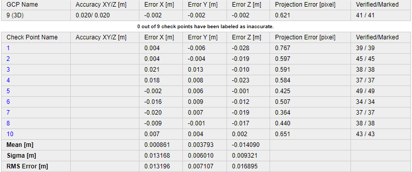
I set up my RS2 over a known point in NAD 83 (2011) and NAVD88, then used Reachview 3 to RTK over Lora to stakeout 9 Check Points in the same datums.
I then flew my mission using the PPK kit on my drone and the RS2 logging as my base for PPK.
I used Baam Tech PPK software to georeference my images and output them in NAD 83 (2011) and ellipsoid height.
I next used NOAA Computation of GEOID18 Geoid Height online service to get the the Geoid elevations for each image and subtract the Geoid height from the ellipsoid to now have my orthometric height for each image.
I processed in Pix4D and my results were very good.
Baam Tech uses one GCP taken on the ground over a target and they call this a Calibration Target.
No other GCPs were used.
Now if only Pix4D Mapper would let you work in local Geoids it could of saved me an hour of work. Pix4D Matic does let you use local Geoids, but it assumes data from the Phantom 4 Pro to be in EGM96 altitude when it comes in.
Right now I am still testing out the workflows. But I work for a municipality and we want to start to document beach erosion/sand migration. Recently the Army Corp of Engineers replenished a large section of our beach that takes a hit from natural and storm driven erosion. Now that I am almost ready (A bit too late to document the beach just after replenishment), I will get a baseline map of the area and then update at at set and event driven intervals. I then hope to use Cut & Fill to come up with an estimate of beach sand loss by time period and event. We then can use this data to help document, predict and plan for future replenishment.