I am not completely sure why, but my elevation is being reported in negative values when looking at the RTK GPS data. My coordinate system is NAD83/Hawaii zone 5 (EPSG:26965). Anyone know the solution to this?
I am new to using emlid so it could be a simple fix. I am trying to use Agisoft metashape to create 3D images using drone and RTK GPS data. For some reason when I try to upload the GPS data, the elevation doesn’t look right causing the ortho and DEM to look funky.
Do you see the same negative heights for the collected points in Emlid Flow? Do you work with the ellipsoidal heights there? You can check it in the info about your survey project.
Also, what heights system do you have in the Agisoft project?
Thanks for the question! Here is a link to the workflow that our team has adopted and created… I’m sure there may be some areas that could use some fine tuning but if you have the time please check it out, this is how we have been setting up and recording RTK GPS data.
Thanks for the questions! Unfortunately, I do see the same negative heights for the collected points in Emlid Flow. I believe we work with the ellipsoidal heights there, because when I look at the data after there is an “ellipsoidal heights” column in the .csv file with positive values. I use the same reference system in my Agisoft project that I used to record the GPS points (NAD83/Hawaii zone 5) I’m not sure if that info was helpful but let me know if there’s any other questions or clarifications. Thanks!
Being in Hawaii it is likely that you may be a couple of meters below the ellipsoid. From the looks of it 3-4m. Also on step 3 of setting up the base I don’t think you need to add the 13.4mm as that should be already accounted for in the software. I think…
Thanks everyone for the assistance! I think I figured it out… When looking at my .csv file again, it looks like my actual altitude or Z coordinate value is being recorded in the “Ellipsoidal height” column. I am not sure why it is being labeled that, but I think it should actually be my orthometric height that is already corrected to GEIOD 12B. At least when I generate a DEM, the altitude seems much more correct.
Do you folks know if it’s something in my Emlid settings, for why it’s being called and recorded as the “Ellipsoidal height”?
Hmm, it sounds quite unusual. Do you have any points with known coordinates to double-check the measurements?
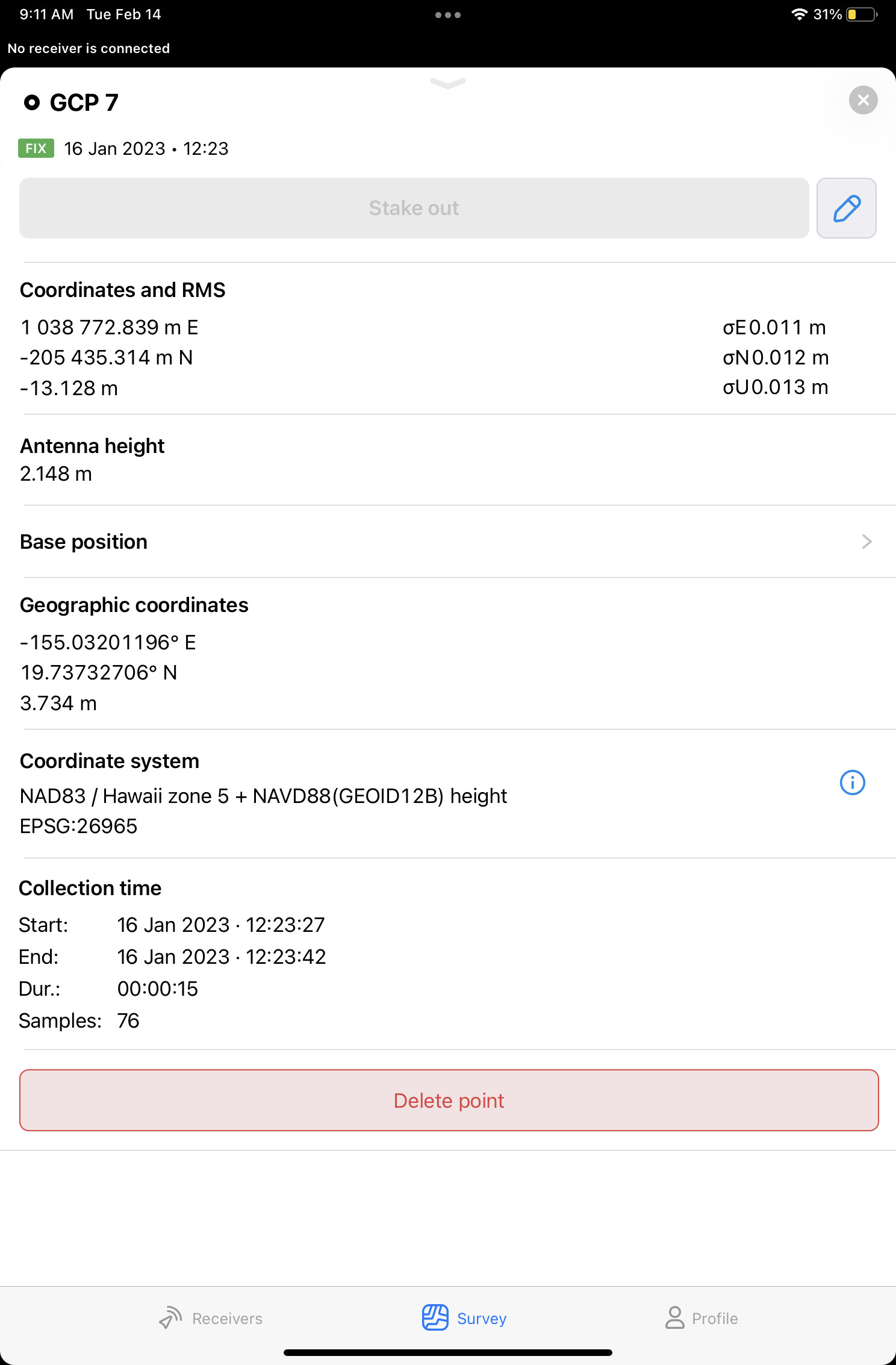
Also, I see in the workflow that you set the base coordinates manually. And in the screenshot, its ellipsoidal height is 3.734 m. Was the base placed on a benchmark with known coordinates? Was this height value ellipsoidal?
No worries. Unfortunately, we don’t have any points with known coordinates, where we were collecting our GCPs.
However, the base was placed on a benchmark with known coordinates. We needed to use a survey grade GPS and occupy the base station/point for several hours to obtain that known coordinate prior to surveying.
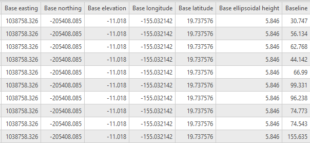
Attached is a screenshot with a snippet of what the base station is recording for ellipsoidal height. You bring up a good point, looking at the base station ellipsoidal height it shows that its nearly 2m higher (5.864 m) than some of the GCP points, and a few of those GCPs were recorded near/around the same area that the base station was located. I wonder if our manual settings is correcting properly to the base station? Let me know your thoughts, and I really appreciate the help.
Alright, I see. Is 3.734 m a NAD83 or GEOID12B height of your base?
Emlid Flow requires ellipsoidal height to be set in the Base settings tab. All the height calculations on the rover depend on it. So we need to ensure you entered NAD83 height.
Actually, there is a way to place the base using orthometric height as well. But for that, you need to use the Choose from project option. Here is a post to learn more about it.
5.846 should be the sum of the base ellipsoidal height you entered and the antenna height over the point on the ground. Was your tripod height about 2 meters?