Hi,
If I set up an RS3 as a base in an area without Internet (African bush) and no known point in the area, how long do I need to have it working in place till its position is at centimeter-level (if at all)?
Thanks
Hi,
If I set up an RS3 as a base in an area without Internet (African bush) and no known point in the area, how long do I need to have it working in place till its position is at centimeter-level (if at all)?
Thanks
It will not be cm level. You will need to use a PPP service.
https://webapp.csrs-scrs.nrcan-rncan.gc.ca/geod/tools-outils/ppp.php
Using a PPP service, the longer your observation time, the better.
In case you missed it in the link posted by timd1971, AUSPOS recommend a minimum of 6+ hours to establish a base position to cm level. Extract here:
2. Ensure each RINEX file submitted contains at least one hour of observations. Centimetre level position estimates are more likely to be achieved with 6+ hours of static observations.
However…you also mentioned “bush”. If you have any tree obstructions you want to give it a lot longer than that depending how bad, and as Dave suggested the longer the better.
As a general guide I would personally be aiming for at least 12 hours or more, the reason being to wait for a complete orbit of the constellations so any multipath gets balanced out as best as possible.
Your judgment re balancing increased risk of gear being stomped on by an elephant or whatever in your geo there.
Thanks for the info!
Thanks for the detailed answer.
The trees won’t be a problem since they’re not that high.
There are no elephants around, but we will probably need to have some make-shift fence around the tripod and figure out a power source for 12+ hours.
The most robust power option is this cable and any common 12v gel cell, fuse it.
Buy Reach RS+/RS2 cable 2m w/o 2nd connector – Emlid Store US
Perfect answer.
AusPos is fantastic imho.
Optimally, you want a 12 hour session, to observe one complete cycle of GPS satellites.
Realitistically, that’s rarely possible, but it is optimal.
Hi Erez,
I agree with the guys’ suggestions. To achieve absolute centimetre accuracy, you’ll need to place your base on a known point using a post-processing service. After you get the solution, you can configure the base by manually typing in the base coordinates.
This way, you’ll have absolute centimetre accuracy on the rover while receiving corrections.
Regarding the powering, the cable without the second connector is indeed a good option.
Are there any CORS type services closer than AUSPOS?
This will reduce the required occupation time.
The required occupation time is directly proportional to the distance from the “base” (CORS) receiver
FYI for global positions AUSPOS is utilizing the full IGS network, currently around 523 stations. You can check the density and baselines for your own geo on their interactive globe map here: IGS Network
Thanks, but there’s no known point and that’s my main problem.
From the other answers, I understand that the best solution is to have my base record for 12 hours and then use a PPK service like AUSPOS to resolve the base position at the CM level, which will also solve my rovers position (GCPs + drone).
I’ve checked it now and the closest point they have is 1255 Km away. Will this cause a problem with the PPK solution?
No CORS service I know about there. The closest IGN station is 1255 Km away.
Good question, but bear in mind that AUSPOS determines a very comprehensive network solution and not a simple differential to a single base.
For example, my results here in a much denser environment typically involve around 14 sites in the network solution with the longest baseline around 1400km.
Yours might be more of a challenge but shouldn’t be bad. As part of a network solution all the sites are also processed against each other and their true coordinates are precisely known so ultimately the estimated 95% positional uncertainty that you will get for your site will be well determined and answer the question.
Do you have access to any accurate marks somewhere in your current region you could test against? Might also be a good check for your transformation from the ITRF2020 result you will get.
Thank you.
Did not know that.
Thanks for your detailed answers - I appreciate it!
I didn’t mention it, but the project will be in Angola and it’s really hard to find any relevant data about surveying in that country.
Hi guys,
I’d just like to add that AUSPOS indeed uses a CORS network for the calculation, not only one station. It means that it can provide reliable results even if the stations are far from your location.
The only thing to keep in mind is that outside Australia, the results will be in ITRF2020.
The simplest thing to do is collect about 12 to 18 hours of data and ship it off to the Canadian PPP service.
https://webapp.csrs-scrs.nrcan-rncan.gc.ca/geod/tools-outils/ppp.php?locale=en
They will give you a ITRF2020 position back. You can also send the data to AUSPOS and compare the two solutions. They should be within a few cm of each other.
I’d recommend the Canadian PPP service since they will make some use of GLONASS data in addition to GPS. AUSPOS is a GPS only service. The receiver you are using only tracks GPS L2C and because the US government has failed to modernize GPS there are still about a half dozen GPS sats that don’t have L2C. In short that’s a bit of a disadvantage over a receiver that can track L2P (which is on every GPS sat). You just have a smaller constellation available to you.
The services are great as they do all the heavy lifting. Free software like RTKLIB can do cm-level positioning using either PPP or differential processing techniques. Centimeter-level accuracy on 1000+ km baselines isn’t a problem with half a day(+) of data. You can even use all four GNSS, but the learning curve is high.
This is all just to say that as long as your site is GNSS friendly any spot on earth can be located to a few cm accuracy in a global coordinate system and this has been the case for decades.
I wouldn’t get too concerned about the capability of an AUSPOS GPS only Network solution, it’s pretty strong.
I’ve been re-calibrating my own reference station against the recently updated AUSPOS V3 and the results are impressive.
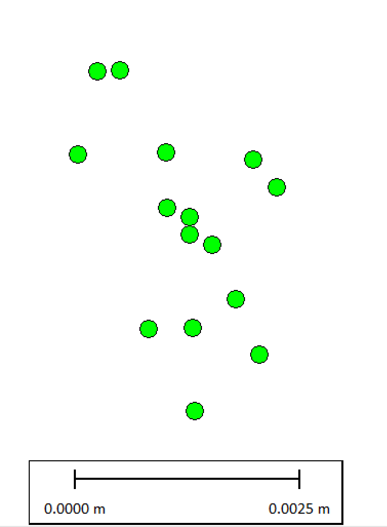
Now the following 15 x positions were collected on a NetR9 + Zephyr 3 Geodetic, and they are all multi-day observations and GDA2020 transformations, but they are a good indication of what’s possible.
The resultant positions all fall within 3.9mm x 2.5mm horizontally, and 10mm vertically:
To give a better visual indication, this is how they scale to my standard 5/8-11 antenna mount (11.8mm diameter on the upper face):