Hello the community,
To get the (x,y,z) location for a point in field, I put the Base unit on a 175mm tripod for 3 hours, recorded raw logging in RINEX 3.00 format, and sent to CSRS-PPP SPARK online tool. It gives me errors:
raw_202008181706.obs Warning : No antenna type RINEX header record was found. Phase Centre Offsets and Variation could not be applied. Estimated height should be used with caution.
raw_202008181706.nav Error : Not a valid RINEX observation file.
Could anyone instruct me how to add the antenna type in the RINEX header? Also, the tutorial (How PPP works | Reach RS2/RS2+) does not mention where to add the antenna height . Is this the problem? I tried to convert the logging data to RINEX2.10, no luck. I also saved the logging to UBX then converting to RINEX (both 2.10 and 3.00), no luck either.
Hi Susan, I may be able to help you if it’s a RS2. The antenna is in the process of being calibrated to be added to the NGS antenna list and others. From what I’ve seen here on the forum, if you are using an online processing service, for the antenna selection, select “none” and add +134 mm to the antenna arp (antenna reference point or height you measured to). From what I’ve read on the forum, this is the approx location of the L1/L2 phase centers per Emlid.
If you have your own PP software, it’s a simple matter of creating a new antenna model using 134mm.
As far as the data error, you can convert the raw .ubx file in RTKCONV to use only GPS and GLONASS and save as Rinex 2.11.
Hi Bryan,
Thanks so much for your reply. I added the antenna height (pole +134mm) in the RINEX file header ( the H of “ANT Delta H/E/N”). I still receive the warming message from the NRCAN PPP service (I used the desktop version “PPP Direct”) since it has the “Epoch of GPS data” option for NAD83. Following your comment, I guess the warning could be ignored.
I do have a concern though: Upon the summary report, it is processed in the RAPID format, which I expect receiving results next day. However, for all my tests, the emails always came in around 1-3 minutes. I wonder if something is wrong. Is it necessary to perform the average single (in Base Mode of ReachView) to get an approximate position before logging?
Any further comments will be appreciated.
Best,
Susan
It happens to me, too. In guide and on PPP service platforms, it is stated that it will usually takes around a few hours to deliver the results. But mostly, they come out within 30 mins. I get the antenna type warning, too.
Susan, I don’t know how long you logged a static observation of the point. I would recommend a minimum of 1 hour if you are expecting or wanting any kind of accuracy. You probably already know this, Precise Point Positioning (PPP) uses the satellite ephemerides to determine a position. The longer observation time will help converge the solution, especially with rapid ephemerides.
I’ve PPP my first solution in Javad Justin PP software out of curiosity, using rapid ephemerides, a two hour observation using all 4 constellations, resulted in a 0.05m accuracy both in horizontal and vertical. This wasn’t on any known point, but I’ll PP the data to the local CORS to find out what the actual accuracy is.
Thanks again, Bryan. I logged it for 2.5 hours (the minimum as suggested in Emlid tutorial). It is not a known point so I do not know the accuracy (the 2 sigma (95% confidence) is fine: 6.7/2/2.29cm for x/y/z. but I understand it is not really accuracy). I will also test the unit with a known USGS marker on campus.
Just the .obs file. The .nav files are pretty generic, they work for all receivers and you can usually find at the UFCORS in the USA if you need data to PP. I don’t usually use OPUS or CSRS, I like PP with Javad Justin software. It really gives a detailed look at your data and results. In my opinion it is a superior processor to anything out their today that is available commercially or online.
Please look at this nice study by @wizprod regarding PPP accuracy vs log times.
NRCAN uses best solution they have when they reply to you. They will not send a following final solution if you initially got say Rapid. You simply get one reply from the service.
Bottom line, the curve pretty much levels off after 5-6 hrs of log time.
Apparently the warning is coming from CSRS-PPP to alert you that you don’t have a calibrated antenna type reported in your RINEX header so your estimated positions are with respect to the antenna phase center (APC) not the antenna reference point (ARP). That is you need to fill in the header section “ANT # / TYPE" in order for this warning to disappear. I found that from a their support (kudos to Brian D) which was very quick and professional.
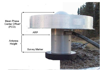
Note the explaining the setup
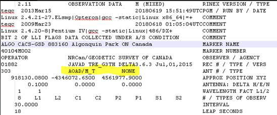
And, see an example of how it should look in the RINEX:
The type is AOAD/M_T and NONE is the dome type
When filling the header field “ANTENNA: DELAT H/E/N” you are taking care for the ARP (antenna height above the marker/tripod/pole) not the PCO.
This information should available here: Antenna Calibrations per antenna manufacturer.
However, I have not found emild products there.
Perhaps one of the moderators can point to where such information can be found for RS+ and RS2 (@kseniia.suzdaltseva) or alternatively what are the correct params in the rinex header one should use? The document here Placing the base | Reach RS/RS+ notes only the ARP as I mentioned.
Hope this helps.
EDIT:
My mistake. Emlid RS2 does appear there:
Code is: EML_REACH_RS2
Dome code is: NONE