RS2 issue with Shapefile

Hi @kseniia.suzdaltseva and @sahatmanikesri

Here are some screenshots of the issue that we are having with ArcGIS and the shapefiles exported from ReachView 3


This is the warning message when trying to load a ReachView 3 shapefile into ArcMap.


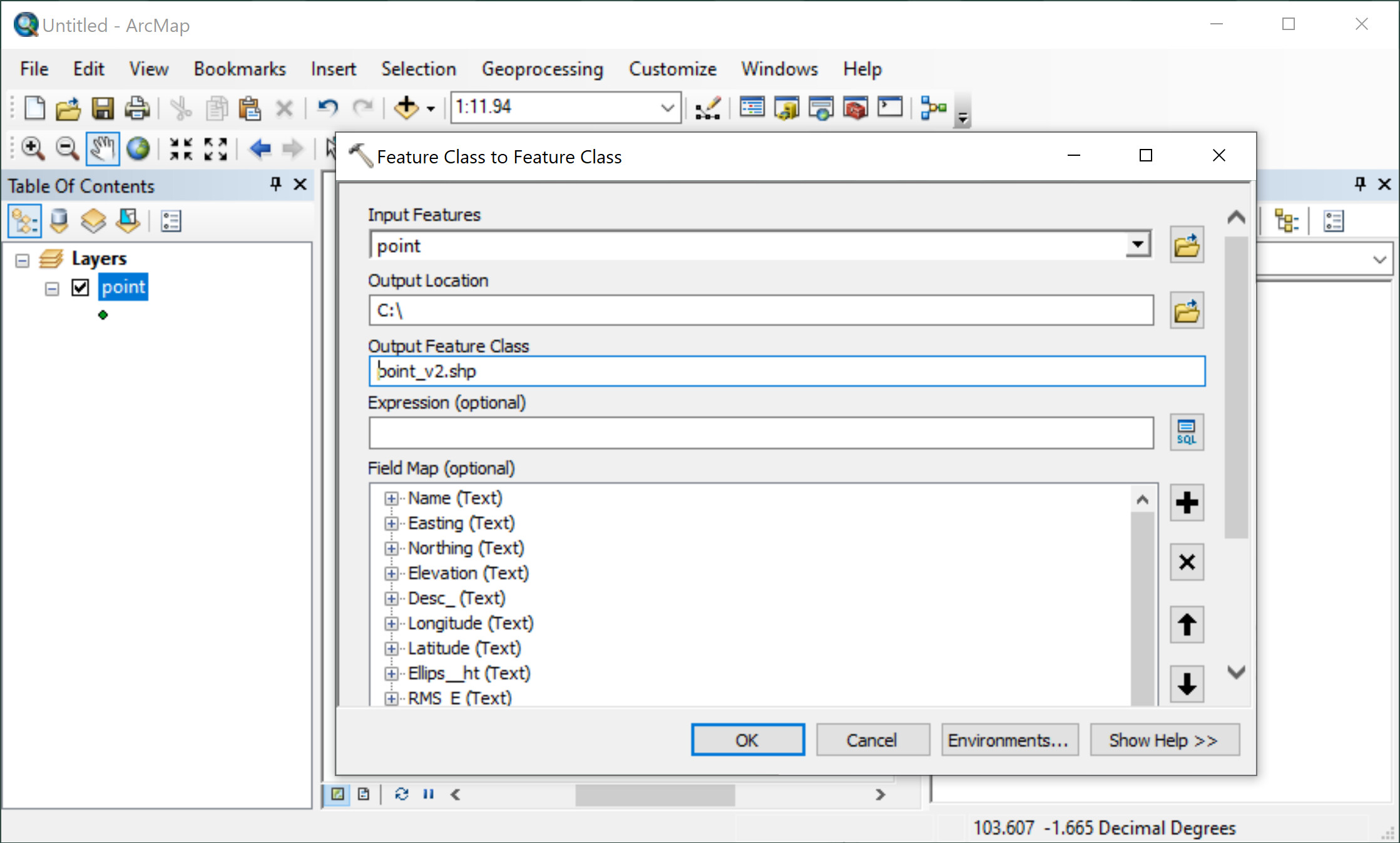
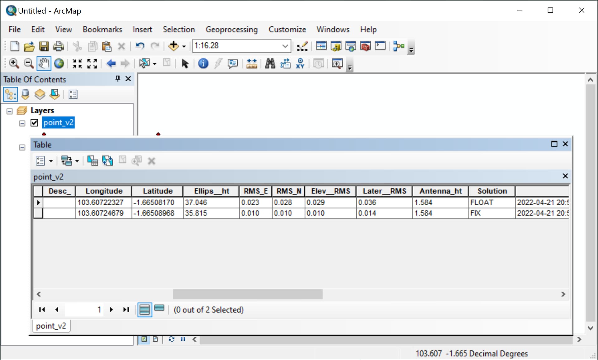
A quick work around is to use the “Feature Class to Feature Class” tool, This creates a new file that the invalid characters in the field names are removed from.


The attribute table of the new file is then able to be viewed (Note that underscores have replaced the “.” and " " characters).

QGIS doesn’t have this field name character constraint, this is just an issue when using ArcMap and ArcGIS Pro.

Cheers,
David

2 Likes

I thank the Emlid team for responding quickly to me.
but can emlid fix the missing file in the shapefile?

Hi @sahatmanikesri

This is the shapefile output from the process above, does it solve your problem?
point_v2.zip (1.2 KB)

contacted the esri team yesterday(ARCGIS) They said there is a missing file,
But why if using RV2 the data can be opened in arcgis

Does the zipped shapefile in my previous post open in your ArcGIS?

The field names in the shapefile changed between ReachView 2 & ReachView 3. ReachView 3 field names include a fullstop: “.” which causes this error:

I don’t think you’re missing a file, all you need are the: *.shp, *.shx, *.dbf and *.prj files

2 Likes

Hi @sahatmanikesri,

I’ll check the SHP file you shared. But just want to ask: did you clarify the ArcGIS requirements for SHP files? What files do they need to be in the ZIP archive?

David @david.burlace, wow, nice catch! Give me a bit of time, I want to check it as well :slight_smile:

1 Like

i thank emlid team,
may i be given an application to process data

this is what they exemplify
IMG-20220423-WA0007

@sahatmanikesri,

Sorry, do you mean an app for PPK?

Hmm, yep, I see. But which of these files are mandatory for ArcGIS? I’m asking since most apps require SHP, SHX, and DBF files only.

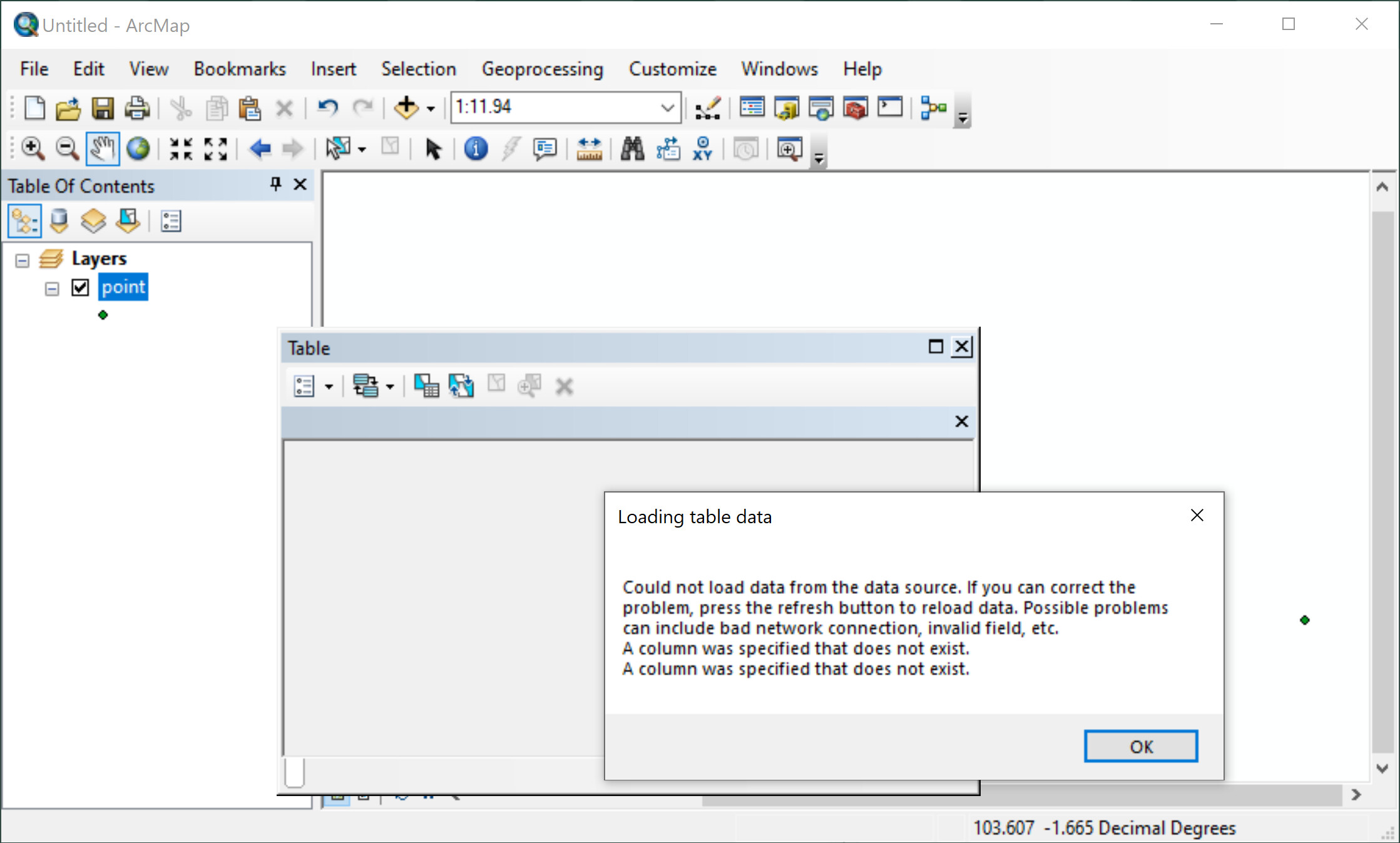
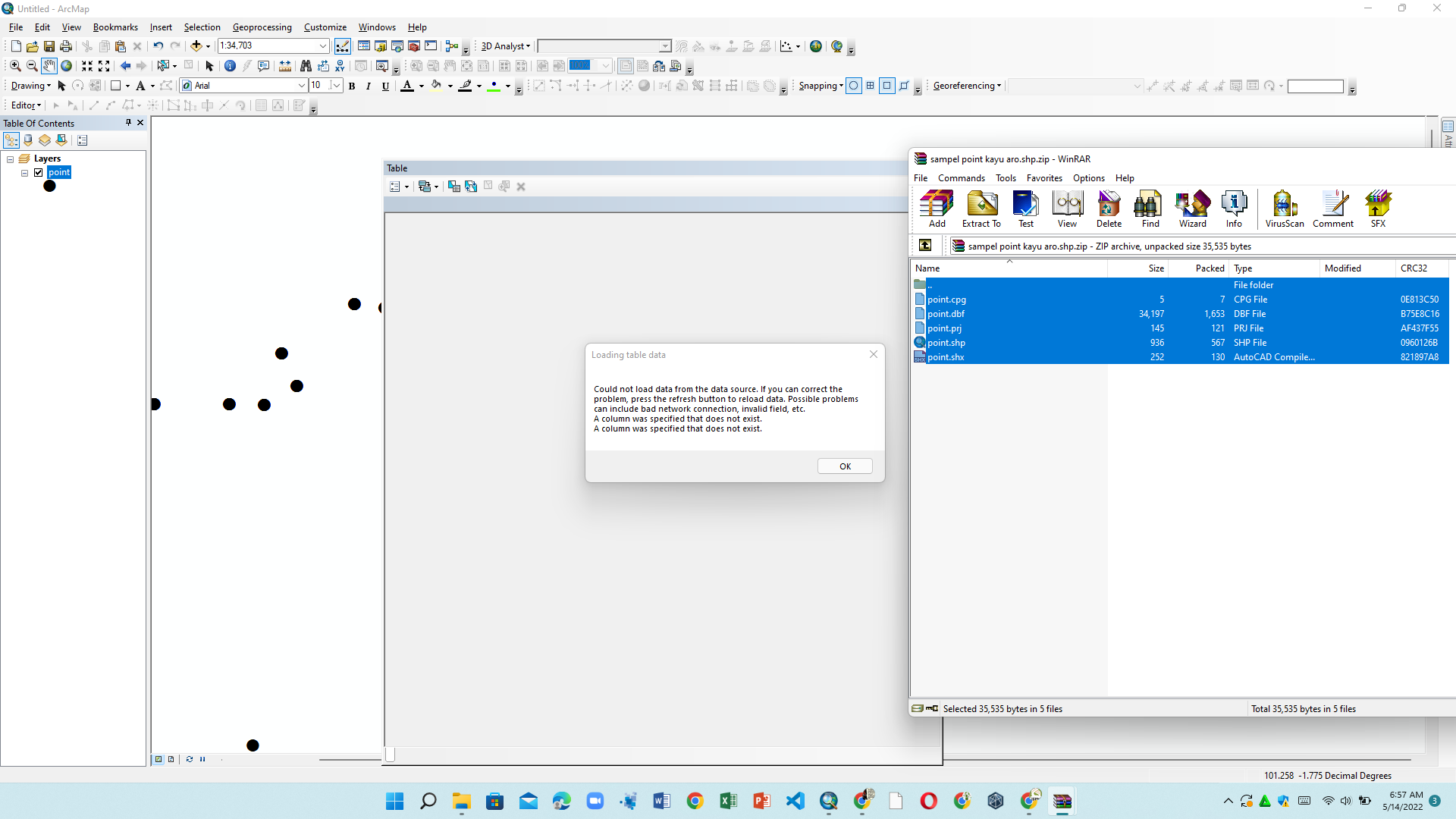
sorry but that’s what arcgis gives.
may i be given an application for rs2 data processing because i am having trouble downloading the application(RTK or something else

Honestly, you would be better to just ignore shapefile entirely and export to .csv

It’s easy to import CSV data in any GIS software anyway and universal compatibility is virtually guaranteed.

Shapefile needs to die anyway: http://switchfromshapefile.org/

3 Likes

Hi good morning
this is the result of reachview3 why can’t it be opened


Reachview3.zip (2.9 KB)

And this is the result of reachview2 and can be opened in arcgis
how come


RV2.zip (4.2 KB)

Hi @sahatmanikesri,

Thank you for sharing the files and screenshots!

I’ve checked both files and can see what David @david.burlace was talking about. The file from ReachView 3 indeed has dots in the column names. And based on my little research of the error you’ve faced, they indeed may be the root of the issue.

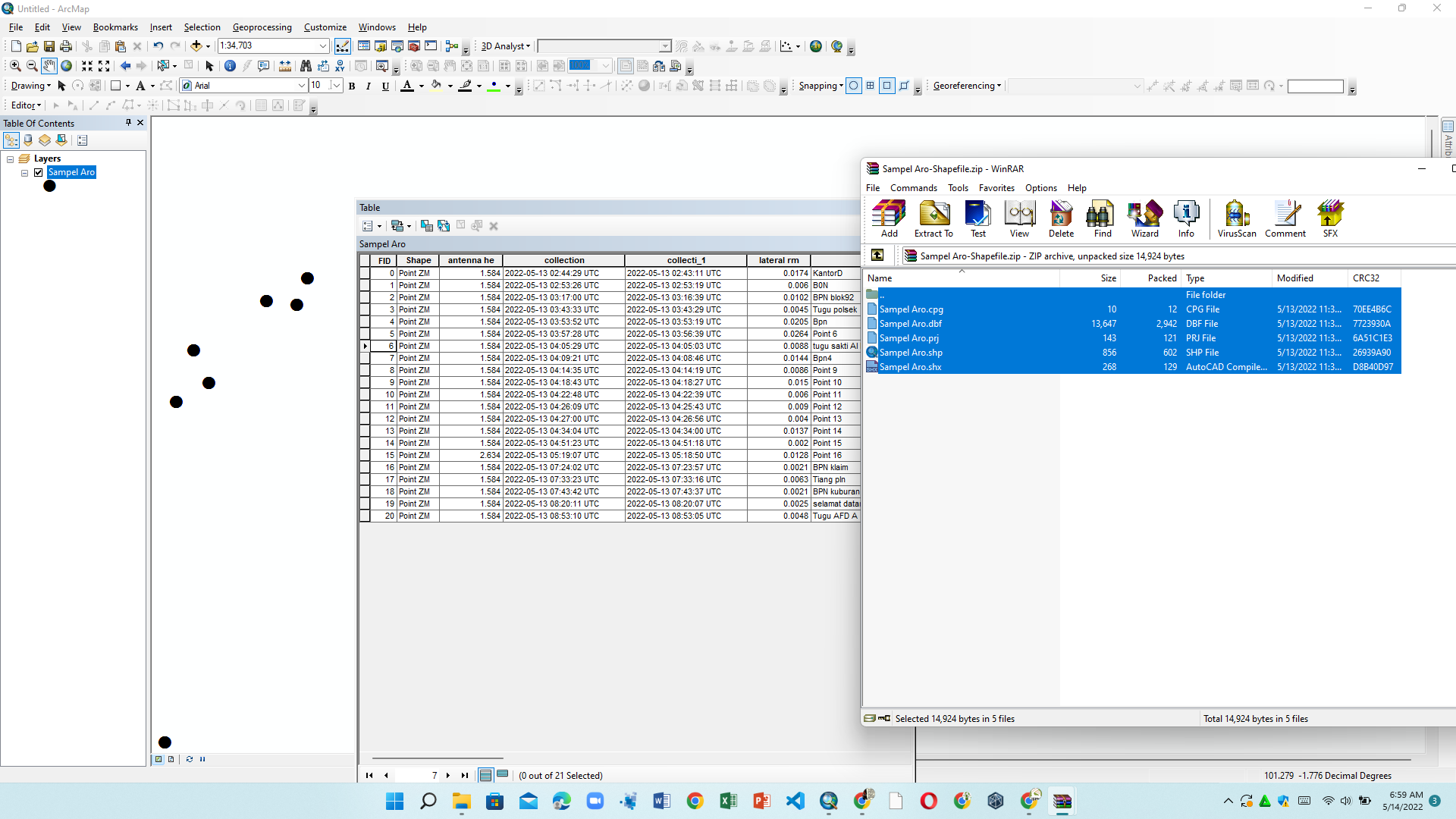
I’ve opened your file in QGIS and renamed all the columns so they wouldn’t contain dots. Can you try to upload this file? I’ve attached it to this comment.

rv3corr.zip (3.8 KB)

1 Like

Sorry for this delayed reply on that!

Here is the link to the Emlid Studio. This is our app for post-processing. All the step-by-step guides on working with it you can find in its docs.

Hi @julia.shestakova,

This shapefile loads into ArcMap and ArcGIS Pro for me without error.

Worth noting that ESRI’s documentation says that spaces are unsupported in field names, They may cause unexpected behavior with some tools; an underscore is a safe alternative.

1 Like

Hi @david.burlace,

Thank you for testing! I’ll share these findings with our devs. That’s the question of compatibility, so we’ll check what we can do here. By the way, don’t you know why ArcGIS have such restrictions?

That’s also cool that you’ve shared a workaround! I believe it may be of great help for some ArcGIS users. And I agree with Gabriel @Gabriel_C – working with CSV files may be a solution as well.

2 posts were split to a new topic: Empty fields in the CSV file

This topic was automatically closed 100 days after the last reply. New replies are no longer allowed.

Hi guys,

In the last update of Emlid Flow (previously known as ReachView 3), we removed the dots from the column names in SHP files. So now ArcGIS software should read the attributes table for SHP files from Emlid Flow like a charm.

Feel free to test if it works smoothly for you and share the results.

1 Like