


New to the RS2 so bare with me.
When I set the base on a State Survey Mark known point, I convert the Australian GDA2020 DMS to decimal (WGS84) and set the base to Manual and head off with the rover shooting GCPs.
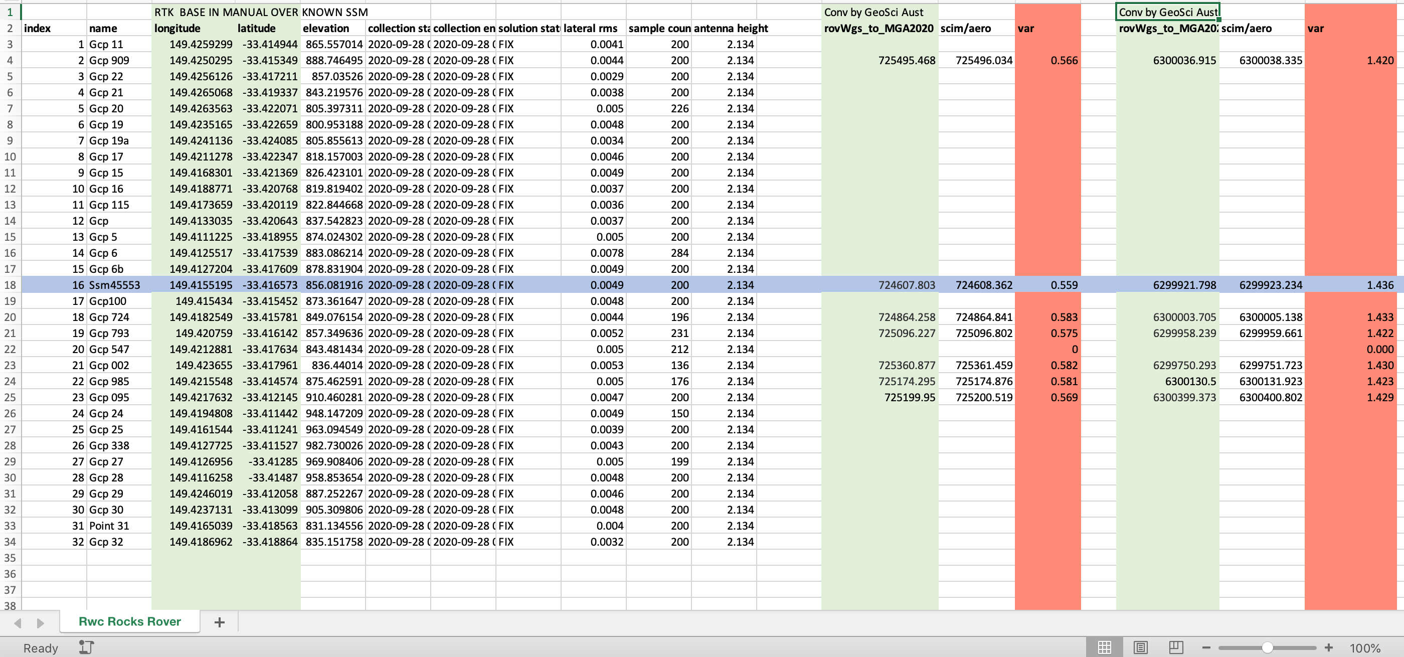
When I convert the WGS84 survey Project LLH to Eastings & Nthgs, I get a consistent variance
Eastings 0.58 and Northing of 1.42. (see excel screen grab)
This variance is measured against another SSM (see screen shot) on site. I also have a set of Propeller ‘Aeropoints’ GCP logging mats. These were logging position after the RS2 took its shot. When these are PPK processed by Propeller to GDA2020 the variance is confirmed.
I’m clearly either missing a step, doubling on a step, or using the wrong conversion / transformation.
Some pointers would be awesome. Thanks
Decimal isn’t the same as WGS84. Did you do a transformation or just a number-conversion ?
Do you also see a difference in elevation?
On the receiver/rover have you set up the project with GDA2020?
Seems like it may be set up with GDA1994 as the shift from 1994 to 2020 is similar to the shift you are noticing.
I have only had them two weeks and my understanding is you cannot set projects to anything other than WGS.
I was lead to believe from my reading that in 2020 GDA2020 is equal to WGS84. So yes I just converted to decimal. I now know there is a subtle difference.
I may have worked around it by reprojecting once in Global mapper.
Thanks
Hi Troy,
If you upgrade to the Dev firmware on the devices, you can than use ReachView 3 and that allows you to Survey directly in GDA 2020 etc.
GDA 2020 is a static datum, so it was very similar to WGS84 as at January 1, 2020. From here they begin to diverge by about 7cm NE per year. So the current difference is far less than the differences you have noted in the excel screenshot
James I did not know this and sounds like a must do. It would remove just another link that could break. I suppose the question then is how stable is V3? oh and what other goodies can it do? is there a feature list?
cheers
Hey Troy,
Check out:
You should the original post right at beginning.
And then maybe skip to the end and scroll back to see the latest changes which are discussed.
Hi Troy,
As James noticed, you can work in GDA2020 in our beta ReachView 3 app. During the beta period, it’s integrated with ReachView 2. So, you can change settings in ReachView 2 and survey in the appropriate coordinate system in ReachView 3. Please note that ReachView 3 requires the latest dev firmware installed on your Reach.
It’d be great if you can share whether surveying in ReachView 3 resolves the issue.
Hi Troy,
In ReachView 2
If you are setting up a base station on a GDA94 benchmark, there is no need to perform conversion to WGS84, just enter the GDA94 values in the base mode settings. As RTK positioning is relative to the base station, your rover output is automatically GDA94. After collecting the data you only need to apply the MGA projection and AHD Geoid if needed.
Same goes for GDA2020. Base in GDA2020 = rover output in GDA2020.
In ReachView 3
In RV3 you can configure your project as GDA94/GDA2020, configure your MGA zone and AHD for vertical. RV3 performs data projection and addition of the geoid model. It is still a requirement that the coordinates on the base station are entered in the same datum GDA94 for GDA94 output on the rover and GDA2020 for GDA2020 output. You will see a hint in RV3 when creating a project “Make sure the your base is in X datum”.
@James & @igor.vereninov thanks for the advice. This is great. One clarification for the current rv2(and gda2020), when setting up on a SSM I Can/Cannot use the AHD ?
Thank you
Troy
@RPAS_Aust, technically no. RV2 has no knowledge of the AUSGeoid, which is required for AHD height determination. So when setting up the base station you need to enter the ellipsoidal height of the benchmark and the output on the rover will be ellipsoidal height as well.
With regard to RV3, So I have to still use DDD.ddddd of the chose datum, I cannot use the the MGA eastings northings figures. That would be too easy, a few ios apps Benchmrk and NSW survey Marks give the MGA but not geographic lat lon. So I have to login to NSW SCIMS site in order to do the ddd.dddd. The reason I ask is that in the RV3 +Measure screen it is in MGA (not ddd.dddd).
Despite choosing Base AHD (21.995m), the rover is showing figures like -22m negative elevation . Rover should be around 7-10m.
I am concerned my age of differential is more often that not 1 to 5 sec!!! even at a 10m baseline in open cloudless sky.
Thanks for listening.
Hi Troy,
With regard to RV3, So I have to still use DDD.ddddd of the chose datum, I cannot use the the MGA eastings northings figures.
The reason I ask is that in the RV3 +Measure screen it is in MGA (not ddd.dddd).
Do I understand it right that you have an issue with entering base coordinates? If so, may I ask you to set the WGS84 base coordinates in ReachView 2 and tell me if it works? ReachView 3 should get the base coordinates from ReachView 2 and transform them to MGA. So, the points’ stakeout and collection can be done in MGA.
Despite choosing Base AHD (21.995m), the rover is showing figures like -22m negative elevation . Rover should be around 7-10m.
Could you please clarify if you have chosen the AHD datum in ReachView 3?
I am concerned my age of differential is more often that not 1 to 5 sec!!! even at a 10m baseline in open cloudless sky.
May I ask you how do you transmit base corrections? The RTCM3 log from the rover may be of help to check the age of differential value.
Hi @kseniia.suzdaltseva, Thanks for picking this topic up.
Please bare with me as I am new to Base & rover work. Maybe I should explain my workflow to date and you can pick holes in it.
- I find a State Survey / Permanent Marker (SSM or PM)
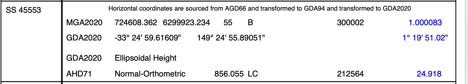
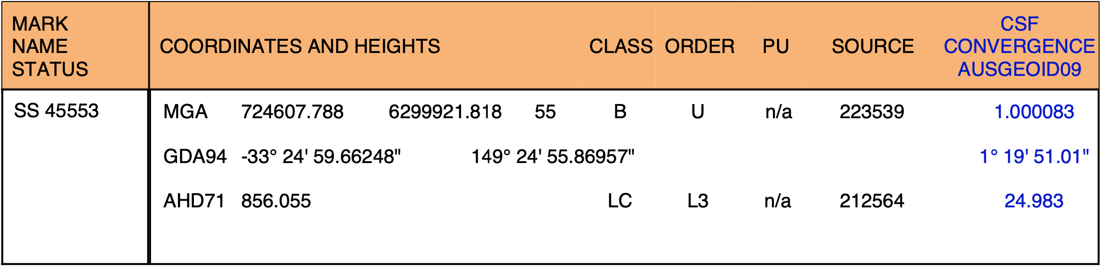
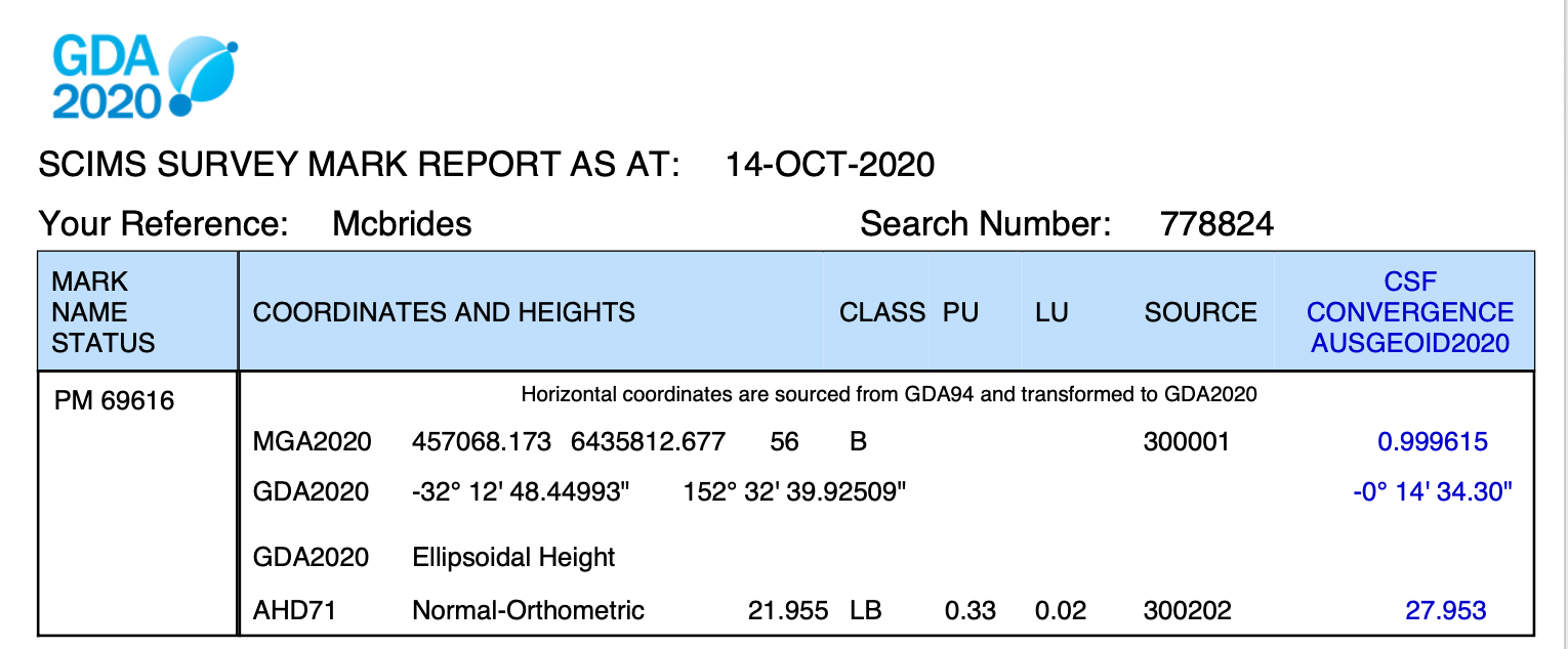
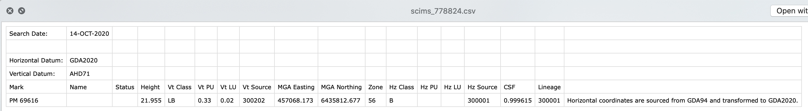
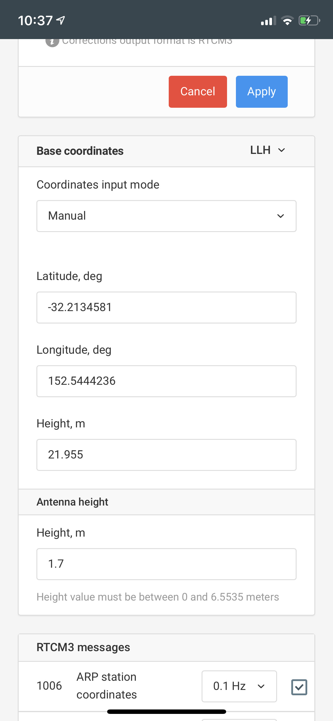
- Retrieve from the government agency the SSM coordinates. These are in either GDA2020 or GDA94 MGA zone XX with AHD elevation datum (see sample) NO WGS (click on image to see right hand side Ellips height in blue)
-
To date I have converted the GDA2020 DDMMSS to DD.ddd and entered them into RV2 with the AHD elevation (in the sample case 21.955m)
-
Should I be converting the GDA to WGS then convert to ddd.ddd? That seems counter intuitve and adds potential error.
-
Should I be using the GDA2020 Ellipsoidal height not the AHD71? AHD is more accurate yes?
-
See RV2 base Manual img
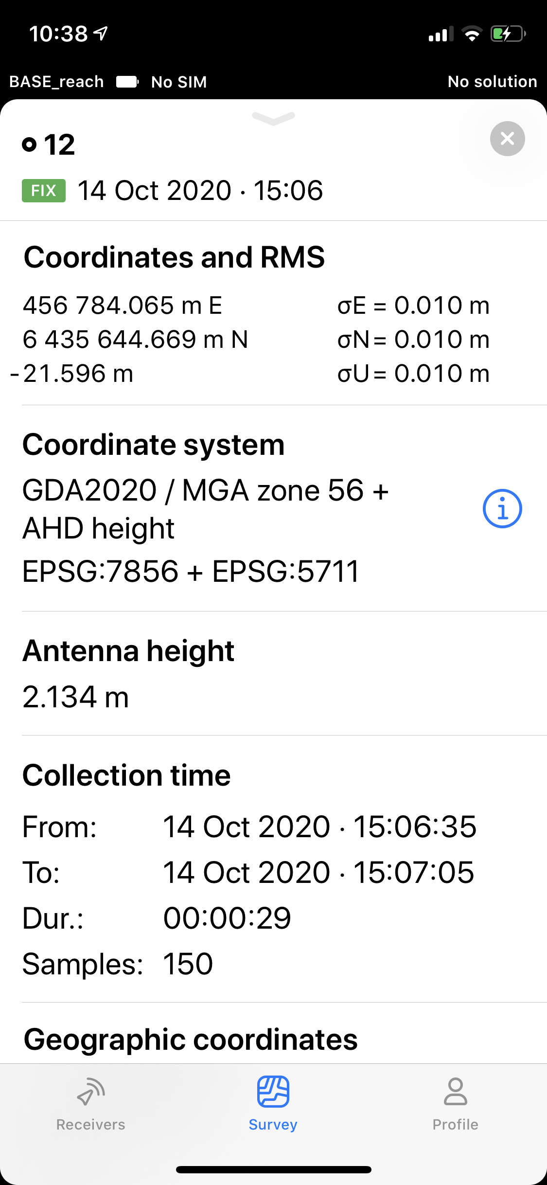
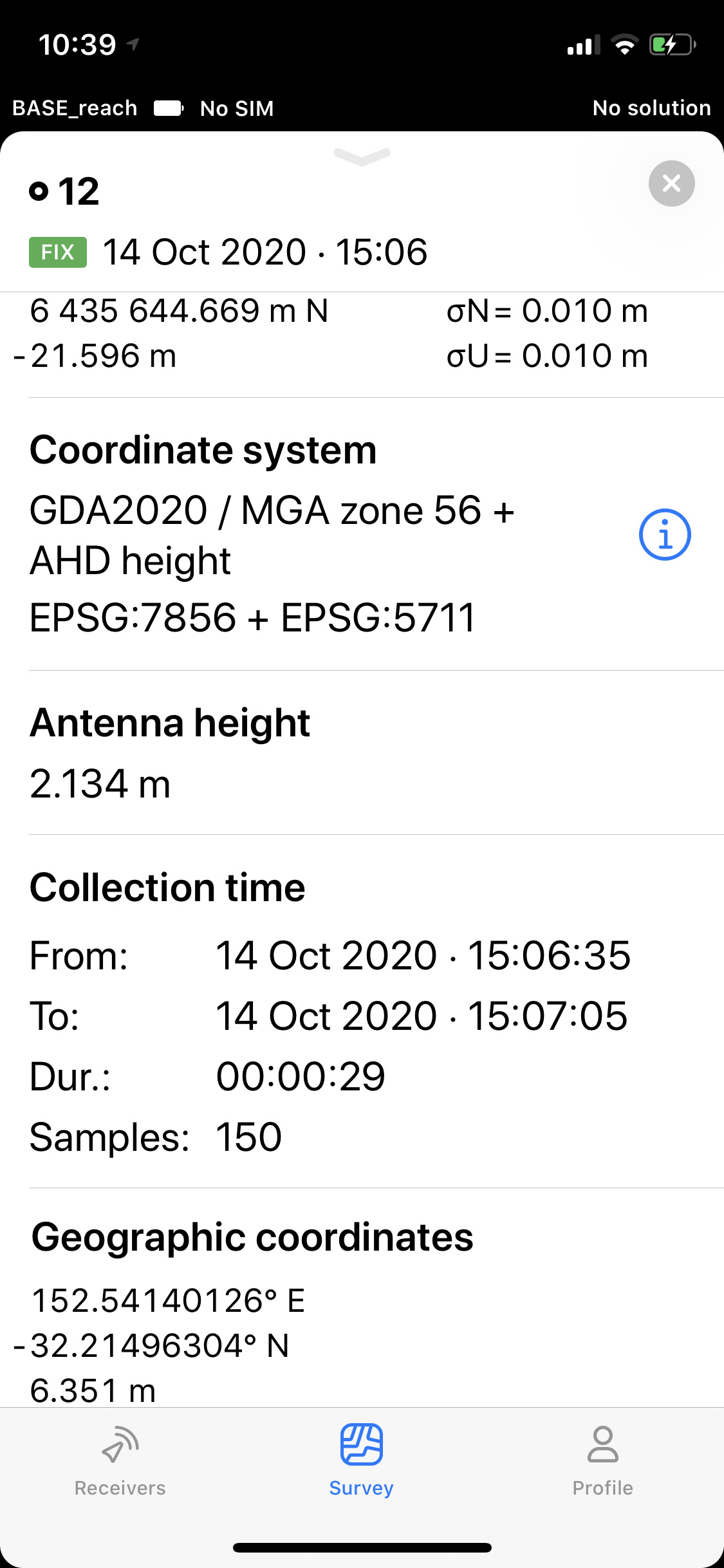
The rover Survey RV3 screen at points looks like - see RV3 #12a&b (I couldnt screen grab the whole page)
I suspect the elevation at the bottom of the RV3 rov stakeout page ‘Geographic coordinates’ is close to the AHD elevation.
- I then export the survey points and use them in Pix4d as GCP. But they import with the negative elevation.
Question on Age Of Differential
I am Manually entering the Known point as in the sample above.
I use Lora to the Rover
I do not understand how to read / interpret RTCM3 logs. I have attached one
base_202010130525_RTCM3.zip (146 Bytes)
Do my RMS look ok eg 0.0010 or should it be less?
In the meantime, with the sample survey above, to correct my GCP elevations can I be confident in changing the -22m to the Geographic Coord elevation figure at the bottom of each stakeout point eg 6.xxm??
Thank you
Troy
admin@rpasaustralia.com.au
Hi @James
Yesterday I read through the whole RV3. It occured to me maybe some of my problem, in particular with strange elevations being exported when AHD was selected, might be an RV3 issue.
Would you mind having a look at my post & attached screen grabs please. Maybe I need to break it up and submit to different threads?
Thanks
Troy
Hi Troy,
To date I have converted the GDA2020 DDMMSS to DD.ddd and entered them into RV2 with the AHD elevation (in the sample case 21.955m)
Should I be converting the GDA to WGS then convert to ddd.ddd? That seems counter intuitve and adds potential error.
You can input the base coordinates in GDA in ReachView 2. In this case, the rover output will be in GDA as well.
In the future, ReachView 3 will have most of the current functionality of ReachView 2. So, you will be likely able to input the coordinates in GDA and AHD in ReachView 3. However, I can hardly provide you with an ETA.
I do not understand how to read / interpret RTCM3 logs. I have attached one
It seems that the log is empty. May I ask you to provide your rover with the real-time base corrections and collect the base corrections log on the rover?
Do my RMS look ok eg 0.0010 or should it be less?
Yes, the 1 mm RMS is fine.
Should I be using the GDA2020 Ellipsoidal height not the AHD71? AHD is more accurate yes?
ReachView 2 requires ellipsoidal height. You can enter it in GDA2020.
I can hardly say that one of the systems is more accurate. They just work with different surfaces - geoid and ellipsoid.
In the meantime, with the sample survey above, to correct my GCP elevations can I be confident in changing the -22m to the Geographic Coord elevation figure at the bottom of each stakeout point eg 6.xxm??
ReachView 3 expects the ellipsoidal height from ReachView 2. If you’ve inputted the orthometric height in ReachView 2 in AHD and surveyed in ReachView 3 in AHD, there is no equal offset you could apply to all measurements.
Hi Kseniia,
Thank you for revisiting this. I saw it first thing this morning. I now have time to consider your comments. First thing, are my eyes playing tricks? I felt sure this morning you said I still need to enter as wgs coord & height. But now it reads I can input as GDA in RV2. GDA is what I used in RV2 and surveyed in RV3 so I didn’t stuff that up. I did use the reported AHD ortho of the SSM so it sounds like my elevations need to be shifted after I go back and redo it using ellipsoidal height. At least horizontally on the globe it should be ok. I think I am getting my head around the RV2 RV3 requirements thanks to your help.