i
i have rinex data and i processed it using emlid studio .can i see the exact coordinates(please teach me to see the coordinates)
why is the true flag disabled?
i
i have rinex data and i processed it using emlid studio .can i see the exact coordinates(please teach me to see the coordinates)
why is the true flag disabled?
Hi @sahatmanikesri,
If you do Kinematic or Static processing, the calculated coordinates will be recorded in the POS file. For Kinematic, it’ll be a ground track. For Static, a single point.
If you collected the points in CSV with Emlid Flow during recording the logs, you can correct their coordinates in Stop & Go mode. Here is a guide on how to work with it. In this case, Emlid Studio will generate a new CSV file with the corrected points.
Sorry, what flag do you mean?
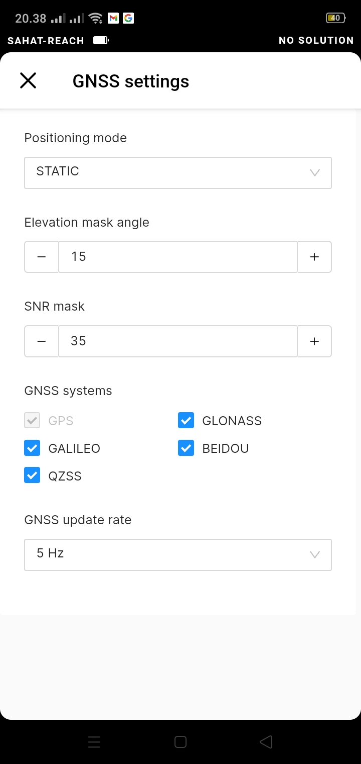
1.in GNS setting why GPS true alert is not active
2. I have observed static PPP for 2 hours and I processed it using stop & go on Rinex. The question is can I see the coordinates that I have processed and give an example
GPS is always enabled for all the RTK measurements. The rest of the GNSS constellations can be disabled, but by default, we recommend keeping all of them on.
To get coordinates of the point using a PPP technique, you need to upload the logs to a PPP service. For example, it can be NRCan CSRS-PPP. They will send the processed coordinates to you in a separate email.
Stop and Go mode allows achieving coordinates of the points collected with no real-time link between your base and rover. To work with it, you need to have base and rover raw data logs and CSV from the rover recorded at the same time. Do you have these files? If yes, you can send them here or via support@emlid.com, and I’ll help you process them and check the coordinates.
Hi @sahatmanikesri,
How are you? Did you have a chance to check my comments above?
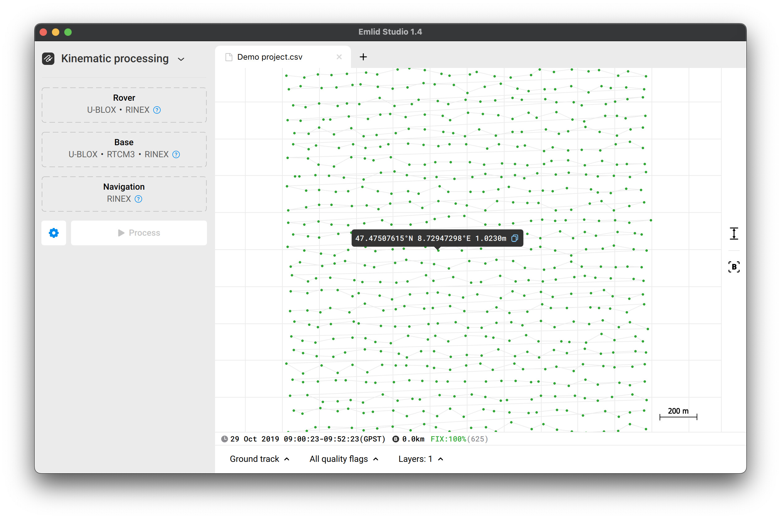
I just thought about one more thing. If you process the data in Stop & Go mode, you can check the coordinates of the points directly in Emlid Studio. For that, you’ll need to drag and drop the corrected CSV file to the app and click on the necessary point:
Is that what you wanted to check?
Hi
I have 1 RS2 emlid, for example, I want to get exact coordinates in a field that doesn’t have a network or cors. I made observations for two hours to see if I could process the data directly without an internet network.
You gave an example of stop & go data and have coordinates, can the coordinates of the RINEX processed data be known as well
2. if I have more than two RS2 emlids and connect to the nearest CORS all of them so that work in the field is more effective and faster. Why can’t the export Shapefile results be read in arcgis directly. So all this time I have to process csv data first while emlid flow is there offers export to shapefile
Hi @sahatmanikesri,
Did you record the log on a single point? Or did you collect several points during the log’s recording?
I remember we discussed working with ArcGIS with you in this thread. Since that conversation, we removed the dots from the column names in SHP files. It should resolve issues with ArcGIS.
Have you tried exporting SHP files from Emlid Flow 8.2? Do you still face the same issue with the attribute table in ArcGIS?
Seems the file you sent wasn’t fully uploaded. So I can’t open it. Can you please resend it?
A post was split to a new topic: Satellite map in Emlid Flow
This topic was automatically closed 100 days after the last reply. New replies are no longer allowed.