


Honestly, if you follow this document with particular attention to “Base and Rover Setup” about halfway down, the rest of the settings are per location. I am finding better results running 14dBm output power. I may continue to go lower until I notice any issues. I surveyed 60 acres on very hilly terrain with a moderate amount of trees without too much problem. I’ve got other issues going on, but they are more related to my data collector. The major area that isn’t very clear with the software and I have allot of trial and error to perfect is what constellations best fit the current condition. I have been running GPS, Glonass and SBAS. I have been having issues with Glonass in particular in my area so that is the first thing I clear if I am not getting good results.
v2.15.4 with a whole bunch of stakeout improvements is out now! Details in the original post 
I know everything is in the works, but would really like DXF import “lines, arcs, curves (splines? polylines? Bezier?! ha!) etc” eventually. ; )
Is there a specific place to ask about the Dev versions?
I just updated from 15.3 to the Dev 2.15.4 and the antenna height input changed from 15.3 version. I also had the save survey point crash which has never happened.
Suggestion, if a person has the correction (65mm) enterred in software, then the Reachview app does not need to add it. You may want to make that optional (ie __ add 65mm to antenna height) If person checks box, it adds 65mm.
I was collecting a survey point and it crashed (ios). Never had that happen before. I also noticed you can not adjust the antenna height for a specific point. Never had the need to do it but that seems to no longer be an option.
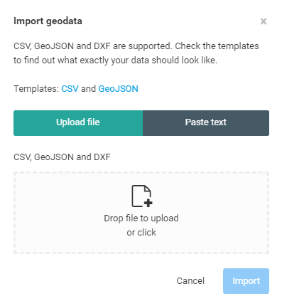
When I try to import both a csv and pasting coordinates, I keep getting At least one column contains an invalid number; column “Elevation”. I’ve tried 0’s 1’s random numbers and leaving them null. Nothing works
Will the boot when power supplied to bottom connection be available for the RS non + units? Thats the only thing Im waiting for to set up my( permanent) base station.
The latest release fixed the antenna height for the entire survey project. However it is still possible to enter a different value in the antenna height field for a specific survey point. but when this is done, it crashes the app.
Was it intended to make the antenna height field so that you can not enter different values for a survey?
The reason my value changed is because my pole slid down and I remeasured the height with my laser for precise height after I put it back close to the original location.
mine slides down to all the time.
I’m no expert (actually quite a novice) but the “power on bootup” was about the only advertised
difference when the Reach RS+ came out. I think for hardware reasons, the “non-plus” units
will never have this feature.
Let me know if I’m wrong.
Please add feature to save NTRIP account information for Base and Rover.
Big issue with v2.15.4: (1) there is a missing step to enter pole height when creating new Survey project and (2) if we enter antenna height, we could save the point being collected.
Just found where to enter pole height. What is antenna height option when collecting point? what value should be entered? There should be instructions or description when new things are introduced.
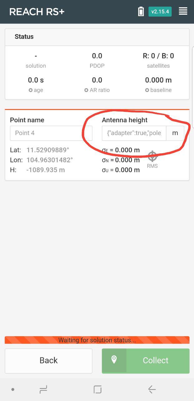
This "Antenna Height " box is not new in the development version. It was in the stable release
And it is explained well right here…
https://docs.emlid.com/reachrs/common/reachview/survey/
As to what you put in, it’s the length or your pole, or how high the antenna is above the ground. You really want the elevation of the ground, not the device on top of the pole. For example, if your pole was 1.4 meters from ground point to the bottom of the 5/8-11 screw, and then you put on the brass 5/8-11 to 1/4" adapter (which is 21 mm) and then place the Reach RS on top (where the internal antenna is 65 mm above the bottom, then you add it all up, 1.400 + 0.021 + 0.065 = 1.486 meters from the bottom of your pole, to the antenna center. The software, after it finds the elevation of the Reach RS device (actually of the internal antenna) and it will subtract your pole height, so it will report the elevation of the ground. As an example, if the position is determined to be 202 meters, the elevation of your geographic spot, where the pole is touching the ground, will be reported as 200.535 meters, which is 202 - 1.465 = 200.535 meters.
Make sense? It really is all in the online documents.
- tj.
Hey guys,
Thanks for the reports. The antenna height is definitely a bug and the team is working on a fix right now. The working version will be out in a short time, so hang tight.
Now, to your comments:
Things like this take time ![]()
Just a bug. Working on a fix atm.
How would we guess that you added adapther height? Or didn’t? We assume that you didn’t. The general idea is to make the whole thing easier by having you work with pole height rather than ARP height.
Please add an example of a file that can not be imported. This might be interesting.
Like I said in a PM to David, Reach RS can not be updated to have such a feature due to hardware design. RS+ was engineered with this problem in mind, though.
This is in our roadmap.
We deliberately removed it in this version. The project wizard now provides a default of 2 meters. Please use the dialog in the open project view.
please also look into WIFI issue where RS+ could sometimes connect and sometimes NOT connect to WiFI network.
Egor
Here is a sample of some points I was trying to add to the stakeout.
name,longitude,latitude,elevation
85-86 East Corner,-111.6131521,40.74258145,7300
85-86 West Corner,-111.6137677,40.7423519,7300
Outside Corner to Straight East Leg,-111.6131257,40.74245777,7300
NW Corner Huser House,-111.6132772,40.74215008,7300
SW Corner Huser House,-111.6131857,40.74200897,7300
Timmyd:
just updated from 15.3 to the Dev 2.15.4 and the antenna height input changed from 15.3 version. I also had the save survey point crash which has never happened.
egor.fedorov:
just a bug. Working on a fix atm.
I just had the “save survey point crash” which is just sort of a “hang” and can’t recover.
Powered off device, then turned back on, it happened again with next save point.
I rebooted, and then restarted, went back to survey, and again got stuck on “save point.”
I’m not sure how to recover. It sits stuck in this with the spinning wheel, but I can change back to the other screens, like “status” screen, just can’t do the survey screens which are stuck.
Anyone know how to get out of this? Is my survey data corrupted now, which keeps it
hanging up?
Hi @summit,
Please, look at the CSV Template in Import geodata window.
You need to use the same structure with the lowercase headers.
Sorry
Didn’t check my link and thought the csv would be shared as text and not in the google sheets UI. I have tried lowercase and uppercase and camelcase. Nothing has been working for me. Here is the sample.
name,longitude,latitude,elevation
85-86 East Corner,-111.6131521,40.74258145,7300
85-86 West Corner,-111.6137677,40.7423519,7300
Outside Corner to Straight East Leg,-111.6131257,40.74245777,7300
NW Corner Huser House,-111.6132772,40.74215008,7300
SW Corner Huser House,-111.6131857,40.74200897,7300
@summit, in this dev version, the name must be no longer than 20 characters and elevation should be float (with .)
