ReachView v2.15.5 dev update - Point stakeout

It’s here!

A new version has been pushed to the dev channel, v2.15.0. Available for all Reach receivers, it builds on improvements of a huge update we’ve just released and contains an early preview of stakeout functionality coming to ReachView in the next non-dev release.

Features

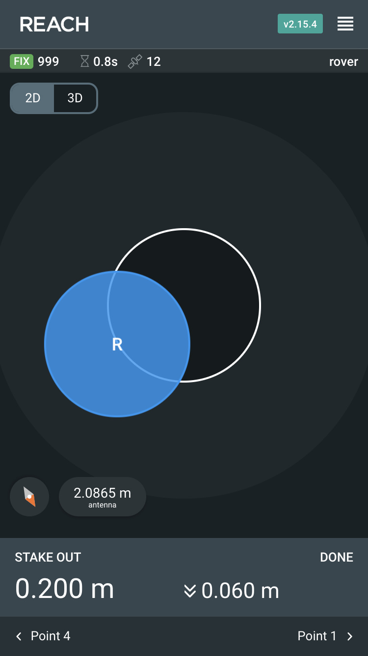
  • Point stakeout. All points in your projects, surveyed or imported, have the stakeout option unlocked. ReachView provides two stakeout views: a map view guiding you to the point and a close up view helping you with precise pole and receiver placement. The close up view turns on when you are closer than 0.5 meter to the point and allows switching between 2D and 3D modes.

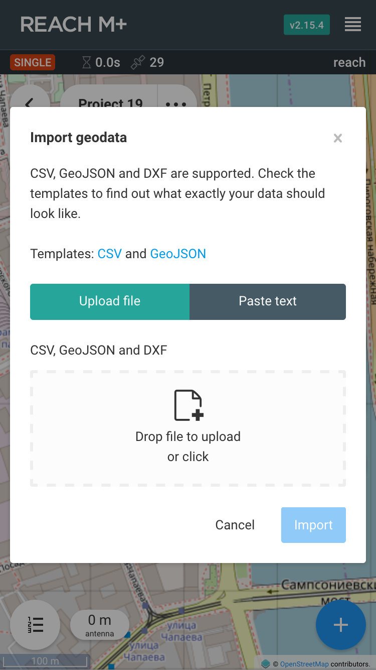
  • Import geodata into existing surveying projects using simple CSV files. The format details are available in the app.

  • Antenna height setting is now preserved project-wide when configuring it during point collection or stakeout.

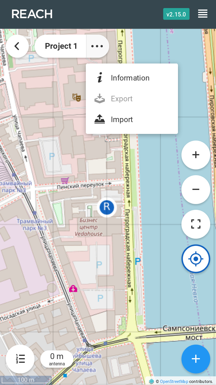
Import geodata from inside the project view:

Stakeout map view:

Fixes

  • CSV height field name changed to “elevation”
  • DroneDeploy CSV format index column name changed to “GCP Label” as per their updated docs

Known issues

This is an early beta and some core functionality is missing. We understand this and plan to fix all of the following issues in a series of upcoming dev releases:

  • There is no solution status indication during stakeout
  • There is no indication of rover’s direction
  • Stakeout accuracy threshold is not configurable. It is fixed at 2.5 cm for horizontal and 5 cm for vertical distances
  • Antenna height dialog does not take device height into account
  • The import file format only allows basic information about the points
  • You will not be able to import data when using ReachView with the Android app(Chrome will work, though)
  • In some situations the import file template link might not work. Copying it and pasting in the browser should always work

ReachView is taking a big step forward in surveying functionality. This is just the beginning, but we are happy to share this version with our community. Can’t wait to hear your feedback!

Best regards,
Emlid team

Update 14.08.2018

v2.15.1 has been released. It fixes a problem with updating from earlier dev releases and a problematic link to the CSV import template.

Update 23.08.2018

Android app has been updated to support importing geodata files.

Update 28.08.2018

v2.15.2 has been released. It heavily improves the point stakeout features introduced with v2.15.0. We’ve added two new key features:

  • Movement direction indication during stakeout
  • Status panel with information about solution status, available satellites and age of differential

Some screenshots of the updated interface:

Moving with Reach during stakeout will cause the rover icon to turn into an arrow. We believe it is a huge improvement for the whole stakeout feature.

The status panel below the header is small but extremely informative. Keeps you up-to-date with the most important information for the moment.

Update 03.10.2018

v2.15.3 has been released. This update brings support for LoRa radios on our Reach M+ receivers. Check them out! :slight_smile:

Also, we’ve increased a Wi-Fi connection timeout, which should help in case your Reach fails to connect to your Wi-Fi from time to time.

Update 11.10.2018

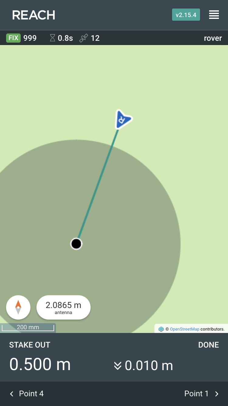
v2.15.4 is out! It’s a huge collection of improvements for our stakeout functionality:

  • You can now import GeoJSON and DXF geodata into projects. Note that DXF support is experimental and it will only accept points. GeoJSON and CSV imports will now accept property information, if you follow the structure of GeoJSON and CSV files we produce on project exports.
  • You can now import CSV and GeoJSON data by just pasting it, instead of uploading a file.
  • Antenna height dialog is now more helpful and interactive. It will automatically add Reach RS+ height and, optionally, add the height of a thread adapter.
  • Stakeout “zoomed in” view now adapts to your direction. No matter where you came from, the point will be right in front of you during the close up stakeout. Pay attention to the compass icon, which will show the actual orientation of the screen.
  • Stakeout will now show the “zoom” area on the map to give you a better sense of proximity to the point

We are also rolling out the long awaited feature - automatic boot when power is supplied via the bottom connector on the Reach RS+! In this version the device will not boot, if you also have USB power connected, but it’s a temporary limitation that will be removed before the new stable release.

This release turned out to be huge, so we are eager to hear your feedback.
Thanks for helping us with this!

Update 16.10.2018

v2.15.5 is out to fix all the problems 2.15.4 introduced! The points should be collectable again. Also includes small cosmetic fixes to the status bar and Wi-Fi screen.

14 Likes

WOW!!! Must be Christmas?

2 Likes

Sweet!

1 Like

Hey just figured out what I’m doing tomorrow! Awesome work guys

2 Likes

It works, I just gave it a quick run!

Although I had a fix solution, I had a low AR around 5 and 4’ish pdop. I was about 5ft from my barn, with tons of large trees around. I was getting local CORs corrections. Elev mask of 30* and snr of 30.

I took 4 samples of the exact same spot with the above settings, all collected within about 150mm(6”) circle.

Now to move my rover and try the stake out! …

I came back to all my collocted points to within about 250mm(10”) horizontal distance, BUT my elevation was off about 4+ meters.

It’s about 10:30pm so I’ll try it again tomorrow

This is such a highly anticipated and longed-for feature to be integrated into ReachView.

I’m sorry to do this to you all, but I’m really left with no other choice:

(I know, I know - Don’t worry. He’ll get tired and stop bouncing around after a day or two. And if anyone else also spams in this thread with an animated gif, the moderator hammer will also come down on you before the serious folk are back to work on Monday :wink: ) No need to thank me for replacing the animated gif :exploding_head: with a sequence of stills. I’m sure it is much easier on everyone’s eyes. :dizzy_face: If you really want to see it, you can probably find it in the edit history (edit).

My thoughts exactly.

8 Likes

Of course, everything is beautiful and effective. But all this is useless without coordinate systems. Or make the function “SHIFT BASE”. And it’s time to make degrees, minutes, seconds. And then they are bored with dances with tambourines.
You need a soundtrack when you receive Fix, when you finish collecting the point and when you hit the point with a breakdown. And then the surveyor with pleasure will start full-fledged work. Also, the point coding is necessary.

2 Likes

Yes, I agree. They are at the VERY beginning stages of this great desired feature. So VERY happy they are moving forward with it as another choice or option for many that full featured survey software / data collectors may be out of reach.

But yes, it’s going to need the basic things incorporated that many other survey software options have. i.e. FieldGenius, SurvCE, MAGNET Field, Leica and Trimble. or even apps such MapIt (with extensions) and MobileTopo among some others.

Such as coordinate systems as you mention, grid shifts and geoid selections. Eastings & Northings, Bearing and Distance. Would be awesome if they brought back the GNSS Predictor… so much easier to pop back and forth in ReachView and it was rather nice.

Visual and AUDIBLE feedback a must when a FIX (or when FLOAT, AUTONOMOUS) is had.

*** A HUGE FEATURE REQUEST I have is to be able to IMPORT DXF / DWG files (that shows the outlines, not just points) and also able to IMPORT IMAGE FILES that are GEOREFERENCED (.jpg with WORLD file)or not as a background or overlay and realtime location / movement shown. i.e. your own drone imaging.
Rotate / Transform / Scale feature along with Local Transformation.

Might as well just use Mapit GIS Pro?

But again, this is only the beginning … so I will be using data collector and software mentioned above in the meantime and I suggest many others do until then.

FYI, MicroSurvey has a FULLY FUNCTIONAL demo of FieldGenius up to 30 points!!! That’s more than enough to play around with and to see what a REAL survey data collection software can do and see what needs to be implemented into ReachView. There FAQs, KNOWLEDGEBASE, VIDEOS, etc are very good also! Native support for Emlid Reach RS also. And NO, I am not a rep for them, just a user of their great software!

http://www.microsurvey.com/products/fieldgenius/download_landing.htm

; )

2 Likes

Good information, congratulations to all the team.

3 Likes

When importing the CSV file for Stakeout, it seems to have bug when the elevation value is integer and not float value.

Could there be an issue with updating from Reachview prior to 2.14.0?

Got this error trying to update from 2.13.0 or 2.13.2 With Reach RS

And this breakes the boot part in Reach which gives me orange light, slow flashing/continuous green light and a nonstopping fast blue flashing. Hard reset doesnt help. Reach is now unreachable.
Reflashing brings it back and updates from Fileversion 2.9 to 2.11.0. Tried to update to 2.15.0 and the same thing happens again.
New reflash, but this time i update to 2.14.0 before i update to 2.15.0. This worked.

1 Like

I cant find this one, could you show us?

Apparently you changed the keyword “height” to “elevation” in the CSV survey export files. Probably the better keyword, but I spent two hours today trying to figure out why by EZsurv software couldn’t process these files.

Who changed it? Emlid?

yes, Emlid

@l3technologycambodia
Could you please confirm if you are using “.” for decimal part and not “,”? Elevation in CSV should be recorded as 12.345 and not as 12,345. Commas in CSV indicate new column.

@TB_RTK
Thank you for the report, we will look into what might be causing this issue.

Test results and feedback are very welcome!

2 Likes

I have the same issue trying to upgrade from v2.13.0 to v2.15.0 on dev channel. I had to reflash to v2.9.0 and just remained on main channel. Upgrade to v2.14.0 worked ok. Afraid to go back to dev channel.

Tiny content bug on Survey - New Project (2/3) screen.

Currently only EPSG:4326 (WGS84 Latitude, Longitude and Height) projection is available. This setting cannot be changedafter project creation is done.

Needs space between “changed” and “after”.

@egor.fedorov

For point stake out, is it possible to add a point on the fly in ReachView?

Or must it be loaded via csv file only? Or from the Survey feature only?