Cameron, thanks for the explanation! But I want to double-check that I understood it right. Let’s say you’ve collected the first point and named it as “footpath 1”. Do I get it correct that you’d like the app to suggest a “footpath 2” name for the next point?
I’m not sure how others collect their data but I do the following
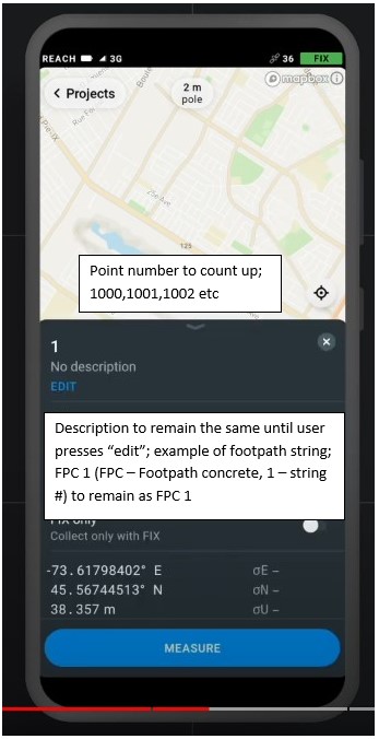
Point number will count up (I start at 1000 for survey pickup for example), however the description is where I store my survey code and string number so that will need to remain constant, eg FPC 1 for a footpath and string ID #1, KB 3 for a kerb and string ID #3, TR0306 for tree 300mm dia. 6m spread etc until I decide I’m not picking up footpaths or kerbs and moving on to a new feature
If the point number can’t increment because there’s letters in there rather than just numbers (As per your example of footpath1, footpath 2 …) I would be removing the ability to put text in as a point ID, that’s what the description is for IMO
Hmm, it reminded me of the request for feature codes that is already on our roadmap. It’ll allow adding the type of the object to a separate data field. So you’ll be able to set “FPC 1” or “KB 3” as such a code.
After reading your comment, I thought we could add an option to keep a chosen code constant for all collected points until you change it manually. What do you think about it? Would it suit you?
That would be even better to retain the description box but have a code box as well, especially if it functions as discussed. This would function very similar to the Leica smartworx software which is great for the surveying market
I didn’t realise that was already planned, is the road map something you can share with the users?
I think that in the larger picture EMLID will need to step back & consider what the scope of Reachview3 is supposed to be.
Basically people want it to become a fully-featured GPS survey tool/app along the lines of FieldGenius, etc. which already has advanced description & point coding tools, stake out tools, auto capture, etc.
If EMLID intends to make ReachView3 a competitor to FieldGenius, great, but if not it might be in everyone’s best interest if EMLID publishes a “terminal feature roadmap” for ReachView that describes not only future possible additions, but feature sets which are specifically excluded from the long-term development roadmap.
This could get interesting if EMLID decided to fork ReachView3 and release a paid upgrade, i.e. RV3 “Pro” version which is designed to compete head-to-head with FieldGenius etc…
Thanks for sharing your thoughts! It’s always interesting to get an outside perspective.
I understand that having such a roadmap may be convenient. However, the roadmap is not something permanent. We constantly add new suggestions to it or modify current requests. That’s why it’s hard to share such a thing.
At the same time, you can always clarify the current status of the necessary feature or suggest adding a new one. Just ask me or one of my colleagues, and we’ll get back to you with the answer shortly.
Hi guys, after another busy week of pickup and setout it’s really driven home just how much the stake out function within Reachview needs to be improved. There is no way apart from taking a screen shot or exiting out of stake out to record your point and those methods are just far too slow and cumbersome to be using all day. Where does this sit on Emlid’s roadmap of feature improvement?
How are we tracking for displaying 3d quality and pdop on the survey screen too?
Haptic feedback and audio verification of survey points being stored?
Good news about audio verification! Now there’s a signal saying that the point collection is successfully finished. The ReachView 3 6.14 version with this feature is already out.
We’re going to improve the Stakeout mode, but the dates are not really clear now. Displaying more detailed info on the Survey screen will likely be a part of this process.
There is no way apart from taking a screen shot or exiting out of stake out to record your point and those methods are just far too slow and cumbersome to be using all day.
Which workflow for point collection and stakeout works the best for you?
The stakeout function works reasonably well as it is, the ability to choose if it works through the points by numerical order or closest point would be a nice touch but not a deal breaker.
A simple record button to use the same settings in the survey point options would be great, you then have a point recorded for position & gps quality to export and keep on record should your setout work be questioned.
Leica offers an auto point record function based on distance travelled, it’s great for vehicle mounted pickup, is this a function that could be investigated?
Known receivers connection. I can connect to my receiver using the web interface, but ReachView3 is unable to find the receiver because I’m connecting via a VPN.
If there was an option for manually entering the IP address of the receiver in ReachView that would be super. Maybe even accumulate a list of known receivers to select from.
I believe it needs some investigation to see what we can do from the technical side. Shared with the team to consider the idea in the future. Love to get some food for thought, so thanks for it!
You put the stakeout files there and you create a job file for each day you measure so you separate things. When you open a job file you can attach reference files, they can be view only or read only.
It’s simple and easy to navigate. When you connect to a computer with a cable you can also se the folders.