


Hi,
I have a strange problem when choosing the project CRS in Reach View 3: I downloaded the new Reach View 3 App and tried it with the Emlid RS+. When it comes to choosing a CRS - of course the same I get the correction via NTRIP - I choose the correct one (APOS: EPSG 31255 MGI/Austria GK Central). When I finished the test survey and downloaded the .csv file I checked it in QGIS - and assigned EPSG: 31255 as CRS. When doing so, the data just did not make any senes. The points could be found somewhere in the Mediterranean sea - what is of course wrong. When assigning the WGS84 CRS to the data - everything is fine. But - that does not make sense as a choose a different CRS for the survey… Could somebody please explain this to me?
Thank you very much
Olivia
Hi Olivia,
When you work with EPSG:31255, the base should be in ETRS89. Could you please clarify if the NTRIP service transmits correction in ETRS89?
Yes, APOS transmits corrections via ETRS89.
Hi Olivia,
Thanks for clarifying this.
May I ask you to share the data with me? It will help to check what might be wrong.
Hi Kseniia,
Thank you for your help  May I ask which data you need? Just the .csv file or also the log data?
Hi Olivia,
I want to check the points’ coordinates first, as it may help understand why the shift occurs. So, I believe the .csv file would be enough at this step.
Hi Kseniia,
I hope its ok if I attach 2 csv files - one where I coose MGI and the second where I choose ETRS as CRS when generating the shapefile in the app. Both can - as it seems - just be displayed in WGS84. You can download the files via: Microsoft OneDrive - Access files anywhere. Create docs with free Office Online.
Hi Olivia,
Thank you for sharing the files! I’ll check them and get back to you with an update.
Hi Olivia,
I’ve noticed that you said you chose a coordinate system when generating the shapefile in the app. If I get it right, you don’t mean ReachView 3, as it supports only CSV output in the meantime. Could you please clarify how do you get the files?
Hi Kseniia,
I´m sorry that I wrote shapefile (I used the Reach View 3 app for the first time - so I was not aware that I can only export .csv files in the end) but you are right - it is a .csv file.
Hi Olivia,
I’ve tried to upload your data to ReachView 3 and QGIS, and the points are shown out of Austria. This behavior seems quite strange to me. Let us investigate it further.
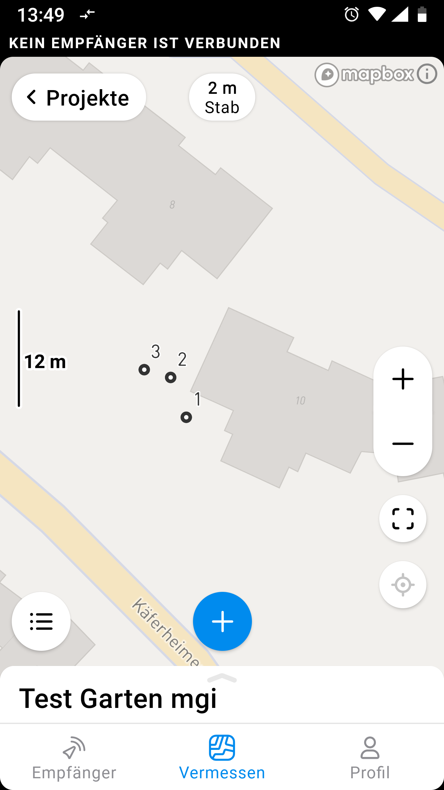
If I get it right that you’ve collected these points in ReachView 3 in EPSG:31255, please clarify if the app showed them correctly during the survey. Is there a chance you can open the project in ReachView 3 and share a screenshot of the points’ positions on the map?
Hi Kseniia,
please find attached the two screenshots. In the App the points where shown correctly. And thats really strange…!
best regards
Olivia
Hi Olivia,
Thank you for checking this! I’ll discuss your case with the team to see what we may suggest and get back to you soon.
Hi, Olivia!
Is it possible to get a screenshot of the project page? You have to tap on the title of the project “Test Garten mgi” and then take a screenshot.
Kind regards,
Jurijs
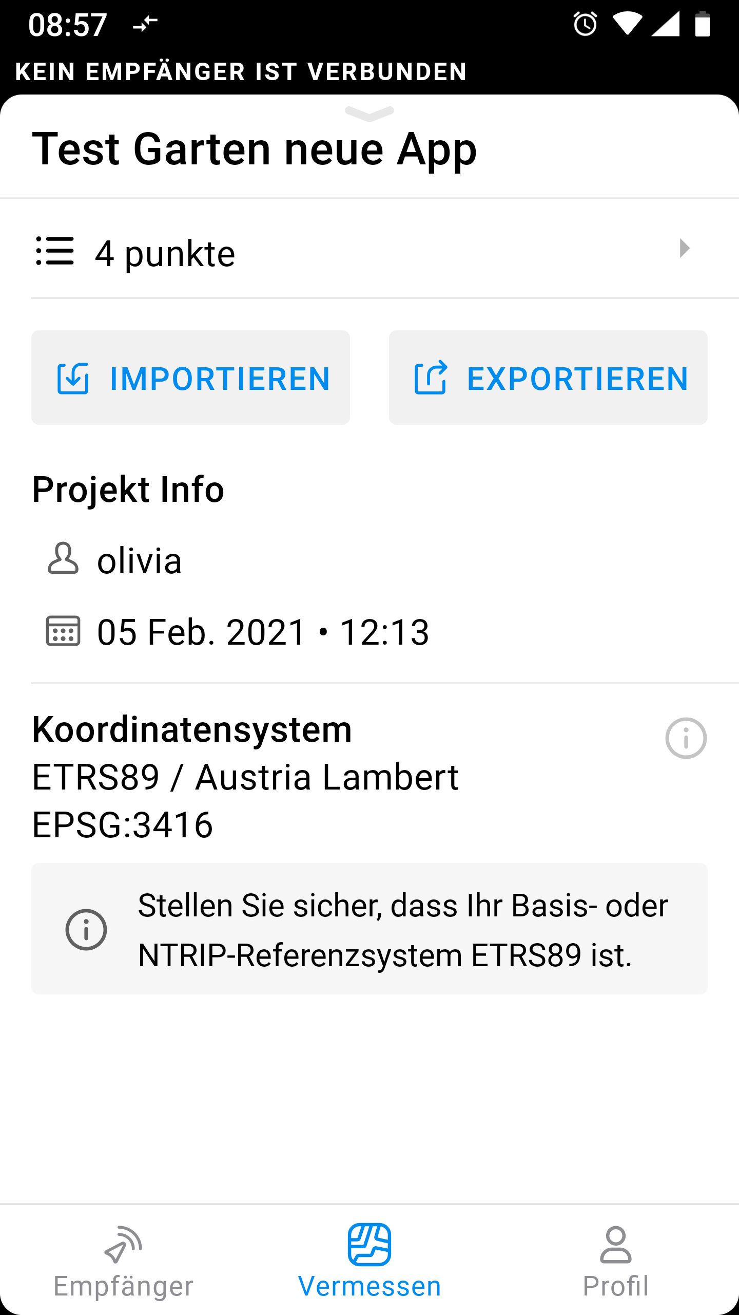
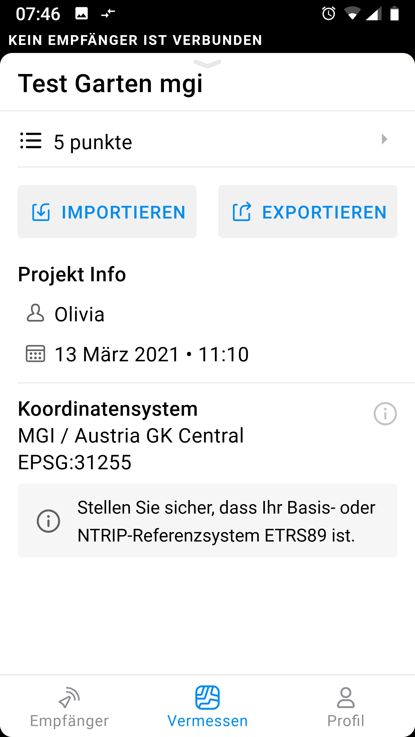
Dear Olivia,
according to this screenshot, your project is using EPSG:3416, but in your first message you mentioned EPSG:31255. Also, the project name is not the same. Is it the same project, which appears on your previous screenshots?
Kind regards,
Jurijs
Hi Jurijs,
there are 2 Screenshots and two csv files - one in EPSG:31255 and one In ETRS89. Both of them can not be displayed in QGis with the assigned CRS - only in WGS84 as your college already tried out. Both of the are suppoted by the APOS correction data - I clarified this with APOS in an E-Mail.
Regards
Olivia
Olivia,
Thank you for clarification! Can you show me the screenshot of the project in EPSG:31255 system?
Kind regards,
Jurijs
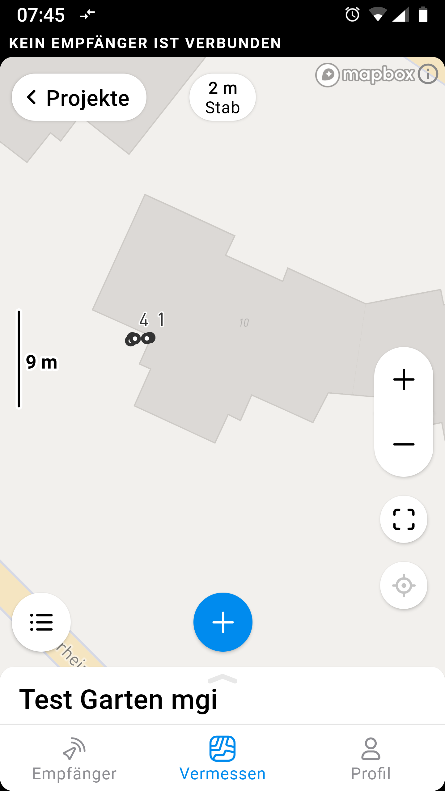
Hi Olivia,
Is there a chance you can provide the screenshot of the Test Garten mgi project with the Project info and Coordinate system shown? It will help to check whether the coordinate system was applied correctly.
Hi Kseniia,
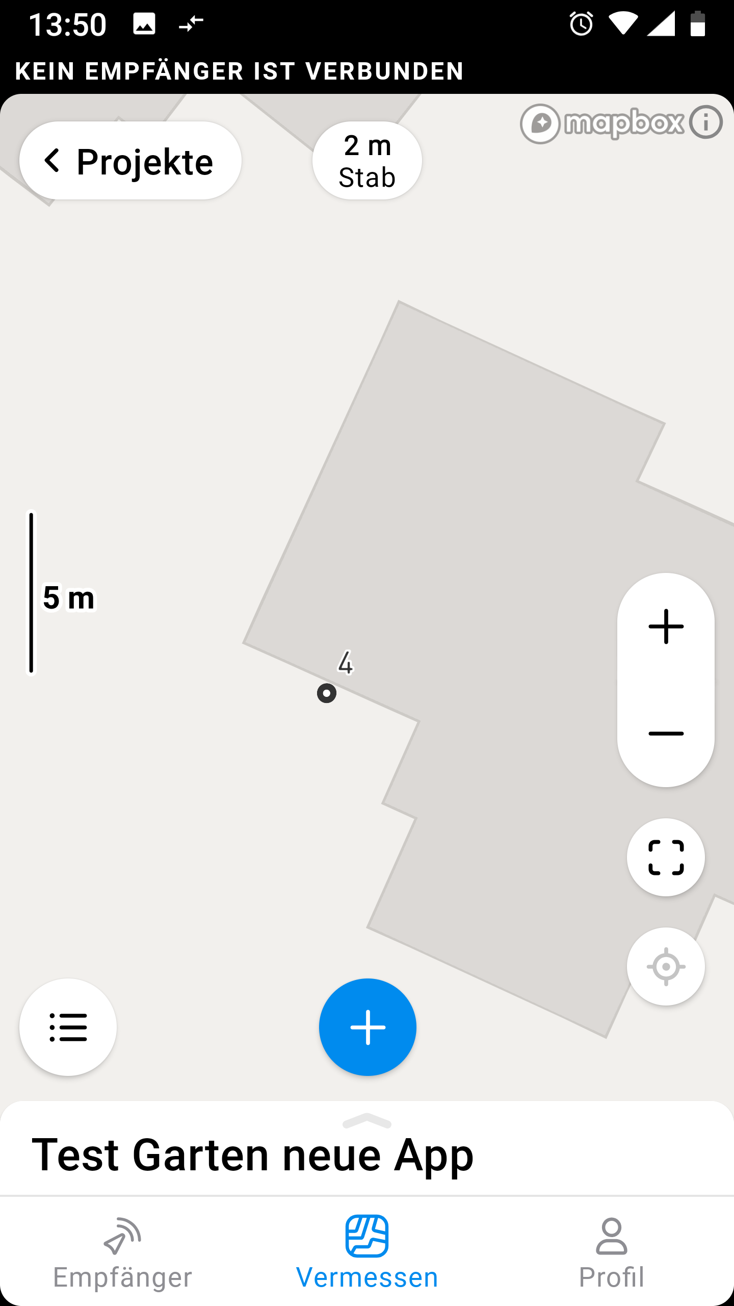
sorry for the late reply. I can not provide the same project agan, but I tried again yesterday and had the same problem as stated at the top… Here are the 2 new screenshots (with EPSG:31255) and the .csv file Microsoft OneDrive - Access files anywhere. Create docs with free Office Online. I really don´t understand, what goes wrong here ![]()
Best regards
Olivia