This might be a good topic to post my questions on base provessing using nrcan
I am collecting data by using the logging mode in emlid.
I am going to submit my results soon. It is best to wait for 2 weeks before submitting logs so that the location info is the most accurate? Im wanting a FINAL result…
What is a good tool to use to convert the results from nrcan into the decimal form for which they have to be to enter into the emild??
Also when my results come back and i enter longitude , latitude and elevation. is that correct then or besides that must i enter the emild height into the height box?
Hi, you might know the answer to my above question. And ill post my results on it and if you want to check them with your tool if you have time then id know im exactly right on.
Do i have to add the antenna phase center offset onto the results from the Elevation of the NRCAN CSRS_PPP results if the type of antenna was unknown in the rinex file which i submitted?? I used the logging tab in emlid web to collect the rinex data file… or can i enter the elevation exactly as it came back and just enter 134mm in the antenna height location on the emlid page? @Florian would you know the answers to my above questions?
To convert latitude in Degrees Minutes Seconds into decimal degrees - noted “DD”, you apply the following formula.
latitude DD = degrees + minutes / 60 + seconds / 3600
If the latitude is North, put a positive sign to this value.
If the latitude is South, put a negative sign.
Same goes with the longitude, with the slight differences.
If the longitude is East, put a positive sign.
If the longitude is West, put a negative sign.
I have to understand what NRCan processed to answer correctly. Could you share the NRCan report here please ?
HP calculator apps do the function conversion with one key. Why re-invent the wheel when you can have a reliable emulator of the best calculator in the world.
This is for Android only however I believe they make several for the apple store.
This is an excellent archive to explain the history of the HP calculator world. These calculators were used by surveyors around the world from the very first HP35 (which my dad bought and I used) to the lastest HP Prime.
I myself have owned most of the HP series’ calculators, my favorite being the HP50. Many of you, especially the younger generation, have no idea of these. Surveyors carried these with them all the time, especially me. They were a necessity in the surveying world, just like carrying toilet paper with you when you ventured in the woods. They were an invaluable tool.
yup so for example here is my ultra rapid report i have to wait longer for the FINAL. but you may show me on this for an example
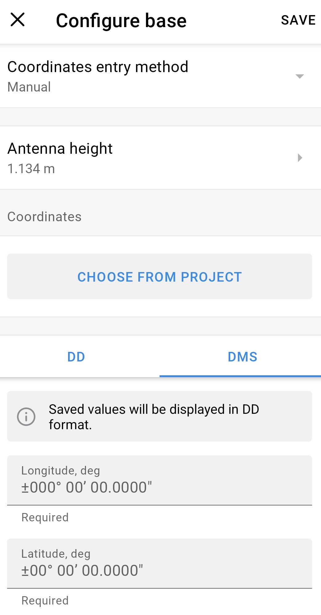
i see it does know the antenna phase offset. so using these for an example what would i enter into my emlid for manual coordinates? i dont follow your conversion calculation im sorry , could you show me please ?
Thanks
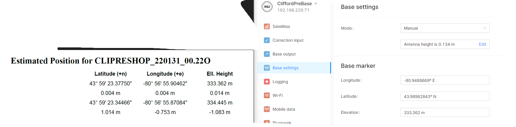
i do understand your conversion factor now yup!, so for the elevation . is the rs2 height calculated into that on this report (see my pdf) it says APC to ARP is .137m is that included in the ELL> Height of 333.288? or do i have to enter it in the antenna height?
You are overthinking this but YES is the answer to your question. The ellipsoid height result from NRCAN PPP is metric and does include the antenna height entered in your rinex file (unlike OPUS which is manual ARP entry). Zero is what you’d want for your permanent base, as you aren’t referencing a point on the ground but rather the base antenna phase center (APC). This is what is being used if you put zero, as the APC is added automatically from NRCAN or OPUS knowing the base receiver ANTENNA information.
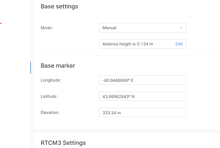
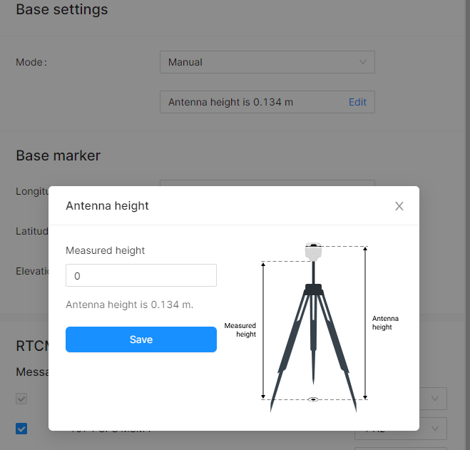
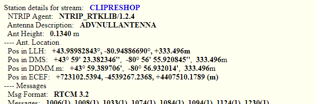
the problem though, is that in emlid base settings when i enter ZERO and save then it still says antenna height is 0.134m i cannot get rid of it , when i click on it and then it says measured height is zero, antenna height is 0.134m i cant change it to zero. see attached pictures. i received back from NRCAN-PPP a height of 333.34 so that includes the EMLID RS2 height and i enter 333.34 and i cant get rid of the aditional antenna height therefor if i look what the ouput location is from the caster it says , 333.474m then its wrong!!!
Yes. That is the APC measurement. It will always factor that in. That is the distance between bottom of antenna mount and the phase center of the antenna. You should not be able to remove that value and you would not want to be able to remove that value. That is your Z position for your permanent base.
yes so. like you said earlier the result from NRCAN-PPP is with the APC Included already. so in my pics you see my result from nrcan it says my base is at an elevation of 333.362m which is the actual APC. i enter that in emlid and now i look at the base position whic his being broadcasted to my rovers a low and behold it is telling my rovers that the base is at an elevation of 333.496
if i know (maybe i dont Know) then it looks like the .134 is geting added by nrcan and again by emlid and being broadcasted as such. ???
Looking at your NTRIP stream, yes the antenna position is showing the 0.134m ARP to L1 difference added in, but also note that the stream is indicating an antenna height of 0.134m (which would be in the 1006 broadcast message). So your receiver should receive both pieces of information and subtract the antenna height from the received antenna position to give you the correct elevation for the base point.
This is just the nature of emlid’s implementation to always include the L1 distance to ARP, but it subtracts out with always including the antenna height message.
I would recommend that you confirm the proper working of your base by using a rover to occupy a benchmark with known elevation and confirming it gives you the correct elevation.
Regarding the antenna height, I’ve checked your report. I see that the antenna type was known, and the antenna height was set to 0. Let’s use the same settings when configuring your base; the antenna offset will be added automatically by Emlid Flow.