Questions about the base initialization

Hello! i have some questions about the base initialization.

I’ve made some tests about the base height in the initialization of an average position.

We’ve set the Base to receive corrections via NTRIP and started the Base Mode with an Average Fix solution and also saved a RTK point in the project.

Then we set up the rover to receive corrections via LoRa from the Base and collected 4 points.

For each point we restarted the Base Mode with a set of configurations:

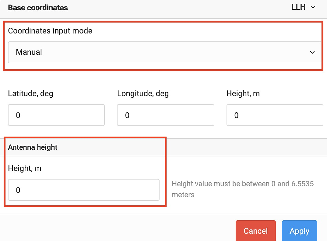
Point Cota 1: We’ve added the antenna height in the Manual mode after following this guide for starting the base and saving the coordinates.

Point Cota 2: We’ve left the Antenna height as 0

Point Cota 3: We’ve added the Antenna height and subtracted the antenna height from the elipsoidal height

Point Cota 4: We’ve left the Antenna height as 0 but subtracted the height from the elipsoidal.

NTRIP Base: RTK point saved to be used as reference to check the height of the Cota Points. Collected with a local federal station as reference.

Follow the CSV file from the test height comparison.zip (667 Bytes) the description says what was changed for each point.

The most promising configuration was the Cota 3 situation,but checking the base reference in the CSV file, the base didn’t had the coordinate in the ground nut was 2 meters above the ground (check height from NTRIP Base RTK point)

And the base that had the same height from NTRIP Base was from Cota 4, but the height from the Cota 4 point was 2 meters below ground

Until now i’ve understood that the Base Mode calculate it’s coordinates where the GPS chip board is located (on the white cap of the unit), correct me if i’m wrong

So we are looking for is the be able to set the base with it’s coordinates reference on the ground so that coordinate can be used in a marker or as reference for future surveys.

Another question, when using the PPP to correct the coordinates from the base, the coordinate is set in the elipsoidal ground or is the actual height, but corrected, calculated by the GPS?

Hi @tec.adriano.menezes,

Yes, you’re right. When the base position is averaged, you will get the coordinates of the antenna phase center.

If you enter the known position of the ground mark in the manual mode, you need to measure a survey pole or tripod height and add 65 mm for Reach RS+ or 134 mm for Reach RS2. The resulting value should be entered in the Antenna height tab. Then, the physical position of the base’s antenna will be calculated and transmitted to the rover. You will see it in the CSV file.


You can learn more from placing the base guide in our docs.

If you are processing data with a PPP service, you can get coordinates with both ellipsoidal and orthometric heights. It depends on the service. Usually, the type of elevation is specified in the report file.

So this reference is related to the survey point in the materialized in the ground, correct?

But what if this coordinate is actually an average position? Since the coordinate is calculated from the phase center, it will be hard to position the GPS correctly with a tripod and leveling base on the actual location of the coordinate.

An example to clarify:

Base is initialized as Average Fix receiving corrections from NTRIP and installed in a tripod with leveling base, so the base reference is in the phase center of the antenna.

After i finished this job, i have been requested to return to the same survey and use the same reference point. So i go to Manual mode and i insert the coordinates i calculated with the Average Fix.

The issue here is that i’m using a tripod and leveling base and the coordinate is located at the height of the phase center of the antenna.

How should i set up this base?

Hi Adriano,

You see the base’s antenna phase center coordinates in the CSV file since they are transmitted to the rover and recorded in the CSV file without any changes.

When you have already placed the receiver on the tripod and measure a point in Average Fix you get the coordinates of the antenna phase center. Since you know this coordinate, you need to measure the height from the phase center to the ground and subtract this value from the averaged height to get an exact position on the ground. Now you know the coordinate of the point on the ground and you can put the base on it next time.

2 Likes

I see and could a optional feature be added in the base mode initialization that could do this? Or maybe set as a option when collecting points with RTK

Because i tried reducing the height manually inside the Manual Mode after saving it and that was the result of the Cota 4 reducing the height of the RTK point.

This information can be helpful since there are a lot of times a survey is done in this way. And it helps a lot with the PPP correction.

Hi Adriano,

The rover expects the coordinates of the phase center. That’s why there is no mode that subtracts pole height from averaged coordinates.

If you want to calculate the coordinates of the point on the ground and set up the base in Manual mode, you can follow these steps:

  • First of all, you need to measure a point in Average Fix

  • Then, subtract pole height (from the phase center to the ground) from the Average Fix height. After this step, you get exact point coordinates on the ground. I’d also advise you to write down these coordinates on your phone or in a notepad

  • You need to enter these coordinates in the Manual Mode

  • Now, you can add pole height in the Antenna height tab

When you put the base on this point next time, you will just need to repeat the last two steps.

2 Likes

Hello @elena.riazanova. Thanks for the steps provided!

Could a feature be added to ReachView 3 to be able to choose between the base phase center height or to be able to substrat the antenna height from the base reference height?

This way we can have a CSV file with both heights (the base phase center height and the ground height) or one of the choosen two.

Let me know if you have any questions, i will be glad to explain my thought process!

2 Likes

Hi Adriano,

Can you describe cases when you need the coordinates of the point on the ground in the CSV? I’m asking because, for example, for PPK, the coordinates of the phase center are needed.

Hello Elena!

Yes, a lot of the surveys here in Brazil are done using this method, that’s because of our land reform and the procedures that INCRA, our governamental authority about the land reform, request. As stated in this post.

Since a lot of surveys are done starting in or implanting a materialized geografical point, this feature is almost a standart request amongst our clients, literaly taken by granted.

It would be a very helpful option to have since our clients request it a lot.

Hi Adriano,

Yes, that’s true. If you want to get centimeter-level absolute coordinates, you need to work with a materialized known point. However, you usually know its coordinates in advance by getting them from local government agencies or determining them yourself.

Sorry, but I don’t understand when you need to get the coordinates of the point on the ground (on which you placed the base) in the CSV file. You or your clients usually should know them before a survey. Please correct me if I’m wrong.

1 Like

Hello Elena,

We need this feature because some clients have checked these surveys and stated that the coordinates of the base aren’t in the ground where the marker is. Our surveyors try to do all they can in one day, so we record the raw data for the PPP and also collect the points in RTK following the INCRA regulation.

Most of the times the client doesn’t have a marker to start the base with, he need to create one for that property and the base having the height on the ground saves time not needing to calculate the actual ground height.

Why can’t this issue be resolved ? Every other issue that is requested gets implemented. The discussion above goes against the grain of any field data collection I’ve ever used from day one. This is exactly why Adriano and others bring up this question and it certainly causes confusion to the user.

If you are averaging a position to get started on or even use a known passive control mark or the previous days work, the coordinates should be in a linear system of the projection used along with the orthometric height, not geographic coordinates or ellipsoid heights. All you have to do then is to enter the antenna height to the ARP, the software would handle the rest. There’s no need to enter additional measurements to the APC, except in Emlids’s way of doing things. There’s just too much room for error in the Emlid methodology. I’ve said this a number of times and it seems to fall on deaf ears.

I’ve used most of the major manufacturers receivers since the early days (1980’s) and I’ve never seen this type of methodology. Perhaps Emlid needs to purchase a different manufacturers equipment to understand what I’m talking about. Ask any other professional surveyor about this, he’ll be scratching his head or either pulling out his hair. I guess Emlid would suggest to use or purchase a third party software to eliminate this problem (which they have in past). I have bought additional software (FG). but this is like buying a high dollar receiver, whether it’s a Trimble, Topcon, Leica, JAVAD or whatever and not having a usable field surveying software solution that is suitable for use. Emlid has a very good opportunity to take their low cost RTK receiver and really shake up the high dollar GNSS surveying community by storm (and they have begun to), but if they don’t start thinking like land surveyors others will overtake them

I understand Emlid is a low cost receiver and it’s an amazing piece of equipment for the money, but certain areas of the software end of the package is lacking; even the basics to feel comfortable in using without questioning the setup of a known point or even getting started on a project.

It’s time for Emlid to really start modifying this.

2 Likes

Yes, i see this as an easy fix.

The same way that the Manual mode adds the antenna height tho match the Phase center position.

A similar feature could be added in the Average Options to substract the antenna height so we could start the base wiht the coordinates on the ellipsoidal or orthometric ground.

Most of the time we don’t have a known marker to start with, so we need to implant one. And being able to start the reference already on the ground were the marker will be is a time saver. Speed up the process without worrying about height calculation.

May look like it isn’t much, but field work needs to be fluid, the otimization of time is paramount and this feature, which is present in a LOT of other GPS brands, is taken for granted, paramount to the workflow

Hi Adriano and Bryan,

Thank you for the detailed explanation! I get your point now. We’ll definitely think about how to implement this in the future. I can’t specify the exact time when this will be released, but we’re adding this to our roadmap.

2 Likes

Thank you @elena.riazanova, will be waiting for this update

This topic was automatically closed 100 days after the last reply. New replies are no longer allowed.