I am attempting to use a single Reach unit as a rover to collect survey points, which I would then like to correct with PPK based on CORS reference data. I’ve figured out how to do PPK for the raw data, but is it possible to correct the individual collected data points instead? If so, how?
If it isn’t possible to correct the individual points, is there a way to extract collected points from the PPK-processed raw data? Thank you!
Yes, all survey points are within one raw file (exportable as individual points only through the “survey” tab in ReachView - as DXF, Esri Shp., or GeoJSON).
I’ve been able to do ppk with CORS before on raw data, but I don’t need all of the intermediate data marking my path from survey point to survey point. It seems like it would be simplest to just apply PPK with CORS to the points rather than trying to pick out desired points from the processed raw data, but maybe that isn’t possible.
I’m not sure either. Can’t find much in the way of documentation, tutorials, forum posts, etc. for that sort of workflow online.
At any rate, do you know if there a way to convert the output RINEX format from CORS post-processing to a format that can be read by CAD or Arc? Say, converting it to GPX or DXF?
I have also been trying to figure out how to PPK the exported Survey points as well. If that is not possible what is the workflow to get precision with our survey points?
Hmm. Toggling between enabling/disabling raw logging could work. Will it be necessary to download and process each raw log separately, in that instance?
From rover. It’s whatever the output of the suggested RTK Lib workflow is from the Reach GPS post-processing tutorial, using CORS files as the base station instead of another Reach unit.
(Kinematic processing | Emlid Studio)
Hi TB_RTK,
Thanks again for your help on Friday. I have a follow-up question regarding KML/GPX export if you’re game for it.
So, I’ve managed to take my data through all of the requisite postprocessing steps in order to export it in KML or GPX format. However, while I did indeed collect points in the field using “single” positioning, I still need to apply some sort of post-processing correction in order to improve the accuracy of those points, which “single” positioning in RTK POST does not allow me to do. I have good CORS data available to me with .obs, .nav, and other associated files. Do you know if it’s possible to apply those corrections and still export as .kml or .gpx?
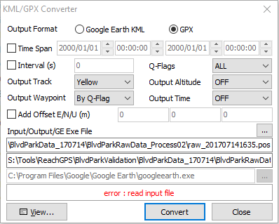
Perhaps I’m doing something wrong. I can get RTK POST to run with my Reach rover data and CORS file, and it will create a .pos and _events.pos file, but when I attempt to export KML or GPX, I get an error message (“error: read input file”).
I did a test run of RTK POST in Single position mode without any CORS correction data, and the resultant .POS file will both export as KML/GPX and display in RTK PLOT. However, when I run RTK POST with Kinematic positioning specified, I get the aforementioned error message while trying to export. These .pos files appear to be empty when I load them into RTK PLOT.
Any thoughts on where I might be going wrong, or suggestions of better settings to apply? Thank you!
Perhaps part of my problem is that the CORS data I’m using is not available as RINEX 3.03. The formats I have available are RINEX 3.02, 2.10, and 2.11, in addition to DAT, TGO, T01, and T02.
Have you experienced any data interoperability problems with different versions of RINEX? I’ve been trying to use RINEX 3.02 CORS data with rover data unpackaged as RINEX 3.03. This is a new data format to me, so I’m not sure how pliable it is.
If you have time to look at the data, that would be fantastic. I’m still on the steep side of the learning curve for PPK, and I’d love to figure out how to get my data to postprocess with CORS.
I changed my export settings to mirror yours and could successfully export points after running RTK POST with “single” positioning. However, when I attempted the same with “kinematic” or “fixed” positioning (which allowed me to introduce my CORS data), I got the “error: read input file” error, and the .pos file yielded a “no solution data” message in RTK PLOT.
Thank you so much for your help, TB_RTK. I’ll package my data and send it to you.