@TB_RTK has generously worked with me through improving my PPK results in the past. Unfortunately, I’m still struggling to find ways to consistently and meaningfully improve my correction results.
I’ve been able to see some improvement from adjusting my elevation mask value in RTKPost. However, the only way I know to do this is by testing a number, seeing if it improves or harms my results, and trying a different number until I settle on one that seems to work for that particular GPS survey. This can be a time consuming process, especially if I’m trying to work through data from multiple days. Is there something that people look for in RTKPlot or another step of the process that helps them more systematically decide what value to use?
Likewise, how does everyone choose what to set for each value in the SNR mask? @Simon_Allen used a string of SNR values (25/25/30/30/35/35/35/37/37) to populate the mask, but I have no idea where those numbers might come from.
Thanks for your feedback - I really appreciate it! We’re all just trying to chase that elusive “100% fix.”
I’ve found that extra effort is better put towards collecting a better log file as opposed to tweaking the post-processing parameters.
So if there is something better you can do with respect to your ground plane; clearing obstructions; or minimizing multipath signals, then put some energy into that.
Still once your logs have been collected, it is not very nice to have to go back and try again, but sometimes that is the best option.
Now as far as your post-processing tweaks, all you are trying to do is keep all the satellite observations that are beneficial to your solution and discard those which aren’t. It is worth trying many parameters, and when you find the ‘best’ value, it will only apply to that particular log file. In another thread there was talk about automation, and maybe that is the easiest thing to do. But without tackling the huge task of making RTKLIB learn and adapt to each log file, maybe you can just use the command line and run several parallel post-processing jobs with different parameters and then just look at the results in RTKPLOT and pick the best one.
For the basics, you can vary these parameters:
AR type (continuous, fix-and-hold, etc.)
Forward, backward, combined
selected satellite systems
pick and choose used satellites by eliminating certain individual satellites ( -G08 -R03 etc.)
change the elevation mask
change the SNR mask (for each elevation)
and there are several other advanced parameters too
and my favorite (for static observations) is to make a very long log file
open up the .obs in RTKPLOT and look at the elevation graph (with colour as SNR)
find the time with the most green satellites (most USA-GPS green anyway)
and process only that “best” segment of your log file using the start and end time options.
If you are looking for effortless PPK software, it’ worth trying EZSurv software!
It is perfect for the Reach RS receivers: import your Reach RS file (no need to convert to RINEX) and click process to obtain remarkable centimeter results (for static GCP and for roving antenna mounted on UAV). The software delivers remarkable results with no special settings (it is all automated to deliver the very best results from your flight data file or GCP).
Thanks @Effigis_OnPOZ that’s a brave claim, I will try it out. I agree with @bide put the effort in to collecting good data. For me the huge one is base site selection and really looking for the things that may interrupt the signals or create multipath.
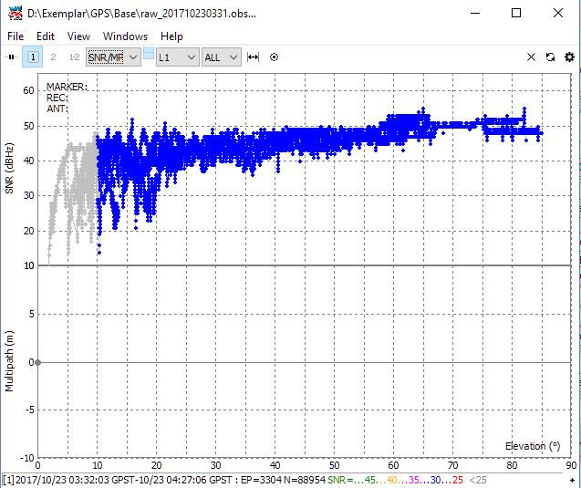
How do I arrive at my elevation/SNR mask angles? See image below. I would set my mask to trim the raggedy stuff off below 35dB at 25 degrees and 30db at 15 degrees. Theres probably a bit of multipath at 40 degrees, would leave that in or mask it out depending on the first run of processing and whether it caused a problem.
The better you set up in the field the less time spent trying to make silk purses out of sows ears in the office.
Of course, their are few things you need to take care of while on the field…
Following the below steps on the field should insure fixed PPK solution with EZSurv:
use a base within 10 km
record data for at least 30 minutes (if the flight is shorter let it record after the flight)
antenna needs to be un-obstructed which is not an issue in the air (if you leave it recording after the flight, make sure the antenna is not obstructed)
EZSurv use the SNR values to weight the raw data observations. Therefore you do not have to reject data, it is all automated. EZSurv “de-weight” bad observations, so bad observations have no influence on final results.
In EZSurv, you can bring in the raw data, you do not have to convert to RINEX, thus EZSurv has access to more signal details for fine tuning. EZSurv works with ublox raw files since 2008, therefore, over time, some fine tuning was done (specific to the ublox binary data) and today it can deliver assume results!
I usually use a default mask of 15 degree, it works just fine. In rare occasion I would bring it down to 10 degree to have more satellites into the solution, but rarely need to play with such settings.
Sure you need to do it right one the field, but it’s nice to be confident that the data will provide reliable and accurate results in the office without any hurdles!