


We are looking at getting a Reach 2+ for marking GCPs for drone mapping. As I understand it, a Reach can be used without a base unit if connected to NTRIP. Can anyone recommend a NTRIP provider in Maryland?
Yes, if your environment can maintain a decent data connection and if that’s the case you should think about an RX. I have heard of KeyNet but know nothing about them. From what I understand Maryland doesn’t have a public network so you may not have much of an option. If you live within 40-50km of your flight areas you could use an RS2/RS2+ as you own NTRIP CORS. There are other options but it depends on what kind of drone you have.
3 Likes
Yeah, from what I understand there is no free provider in Maryland. I could possibly set up a base at home but most of my projects tend to be scattered all over the region. I will look into Key Net. I’ve had a hard time finding a provider via internet search.
2 Likes
Hi James, I use the HxGN SmartNet - Satellite Positioning Service here in Texas and have good results with the service. Or course you have to have cell/internet service in order to use it.
I plugged in some info pertaining to your location into the website subscription calculator and it would run you about $208.33/mo ($2,496.99 + tax for 1yr sub., paid at start of service) for the SmartNet Mid-Atlantic South (5303422) Sub-Regional Coverage—Includes coverage in MD, VA & WV, so not exactly cheap. I pay a little more than 1/2 that amount for state wide service in Texas. Not cheap either, but I wouldn’t be without the service. I envy the states that have free or low cost connections!
Here are a couple of links to the service:
HxGN SmartNet - Satellite Positioning Service
https://www.smartnetna.com/hiw01_intro.cfm
Subscribe
https://www.smartnetna.com/store_product_selector.cfm
And here is a link to their write up on the following question:
Network RTK — Is it worth it?
https://www.smartnetna.com/hiw04_worthit.cfm
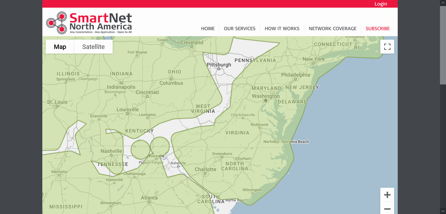
Partial Network Coverage Map for your area
And here is another discussion that you might be interested in viewing:
Good Luck, Mark
Thanks you so much. This is great information. Hoping to find a service I can go month to month for now but will take what we can get.
1 Like
Do some testing with rtk2go.com This might be enough and checking the map, there are 3 or so stations in Maryland. It’s just that there is no guarantee those bases will continue transmitting forever. You could increase coverage though withou your own base in that network.
2 Likes
Or that they positions they transmit are anywhere near correct…
1 Like
Interesting. So is that data crowd sourced?
Yes, anyone can contribute with their base and they themselves decide the base coordinates.
2 Likes
Yeah, rtk2go is definitely caveat emptor.
I guess if we wanted to validate, having access to a 24h raw log of a base would be interesting.
This topic was automatically closed 100 days after the last reply. New replies are no longer allowed.