I normally use the stakeout function or single point collection in the survey mode. Multi point surveys are not my strong point anymore.
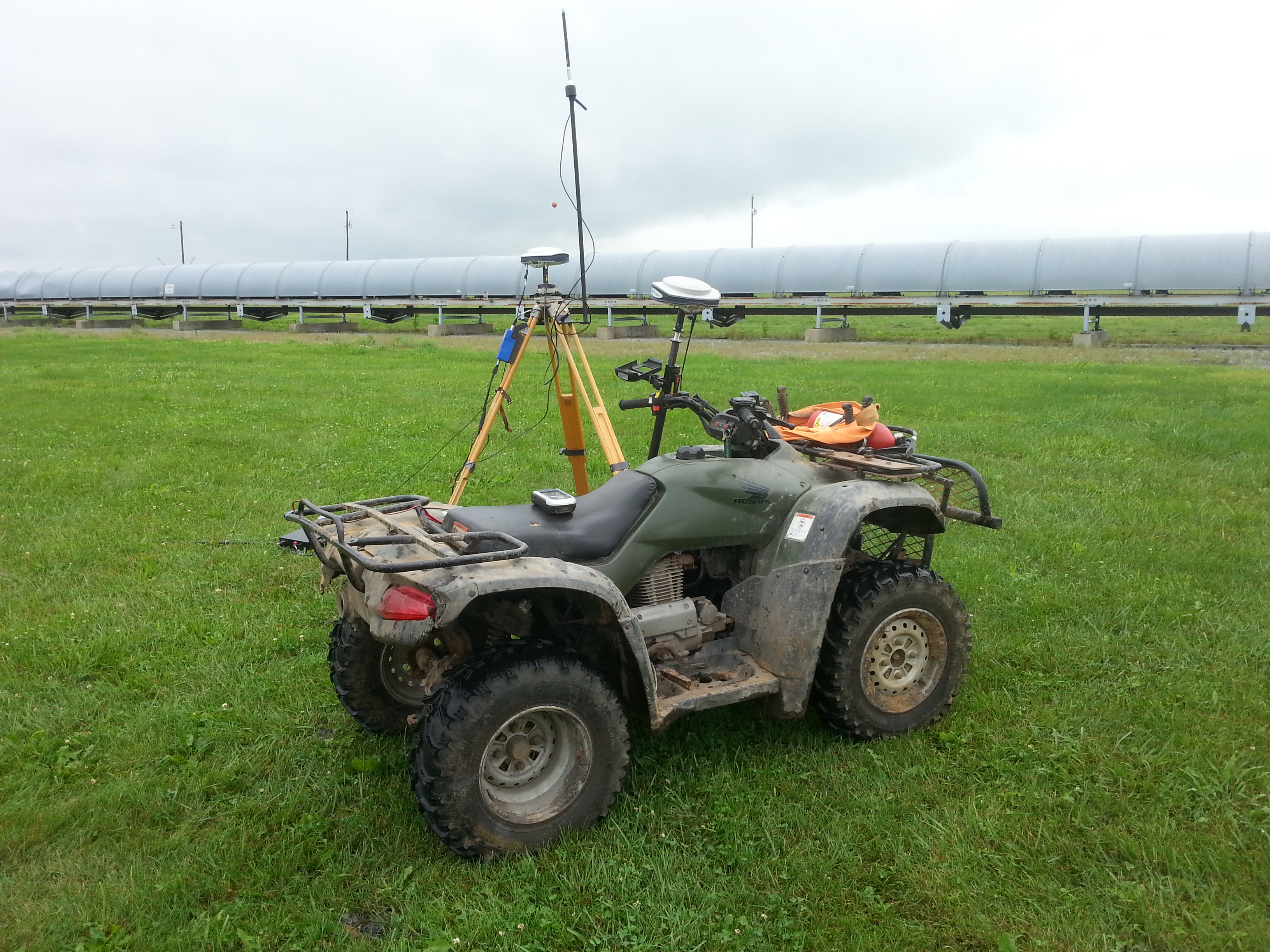
I always use two reach systems, one as base over a known NGS benchmark, and one as a rover.
I typically wait until I have a FIX solution, then begin my surveys.
Here is my question:
I come from a situation where we had Thales survey grade RTK equipment. We did monthy topo jobs on stockpiles. On the data collector i could turn on Auto-By-Interval and start collecting points every 5 seconds as i drove the atv around the stockpile. The output file from the data collector was a .csv with stste plane and asl elevations. I was spoiled.
I now work for myself and do not have that $35,000 setup.
I have an area that I need to perform a topo survey on tomorrow. It is 40 acres. I cannot drive so many feet and hit “collect point” for this entire area. I need to rigidly mount the rover to the atv and drive while it collects points at 1 or 5 Hz.
I will have the base setup over a NGS monument and sending NTRIP corrections to my rover. I will not start the topo until i have reached a FIX solution.
Is there any way that I can be logging the FIX corrected points in either survey mode or saved in reachview in realtime due to the NTRIP?
Or is the only way to perform this survey by post processing: setting up the base, then turning on the rover and driving my topo loops, then downloading the raw files from each device and running them through RTKLIB?
My end goal is to get a point output file to be inserted into AutoCad (Carlson Civil Module) for contouring
If you are looking for an overall auto-topo then that is easy inside of ReachView, but I think you are on the right track of logging and solving later. You can create the full track of your trip and have elevated points much closer together than you would think. The tough part that I am not proficient at yet is how to cut out the parts of the track you don’t want. I suppose you could use time intervals, but there has got to be a better way.
I am not knowledgable with drone surveys, but hope to check that out one day just for fun… but would using a drone be something the OP could consider, versus driving around on a atv? Then PPK it?
I guess what is the advantage of using a rover (RS/RS+)(know many advantages of new RS2, but leaving out) mounted to an ATV vs a M+ (with LoRa option) on a drone?
I know, I waited pretty late to slink in here asking technical questions!
Can you expand a little more on how i may perform this within the survey tool in ReachView without having to click “Collect” every few seconds. I didnt know there was an option!
I also have two phantom 3 pro drones that we use for mapping. Along with 2 GCP’s that we use the Reach to survey in. We have an account with drone deploy for mapping also.
Up to this point, i have have only used Drone Deploy to do vertical images and georefrenced orthomosaics for site planning and horizontal measuring. I know they offer an export function in DXF for elevation contours. This would slip right in to AutoCad.
I have trust issues.
I know that I can get centimeter level acchracy on my GCP with the reach. I am just nervous about how accurate the elevation contours would be over this grassy field. Im confident that the contours would be top-of-grass elevations, which I can account for, but how accurate and precise do you think they are?
I think as long as you have clear sky view and the right conditions for FIX the entire time, you should be able to use the auto-save rules… i.e. FIX and auto collect points every 5 seconds as you run the area?
Probably the new RS2 would come in real handy for jobs like that? Especially with the beefier 5/8 thread.
Not sure if the shock damping mount for RS works RS2 or if a new design needed for a RS2 mount?
Thank you, I guess i misunderstood what the auto-save rules were.
I always thought that auto-save meant that after hitting collect it would observe for 5 seconds then “auto-save” that 1 point. Then you would have to manually start the next point.
Yes this is a scenario to think about using a drone, but you have to understand how the process is going to work and you need the right software. DroneDeploy recently-released the ability to download DTM’s, but I am not sure which plans it is available on or if anyone can use it? I use external software for this process so I have much more control over the process, but theirs is getting better all the time.
The key point to understand about this process is how the software recognizes low points and then has the ability to filter out everything in between. Relying on a piece of software to automatically do this would make me a little nervous as well, but I have it under full control so I can usually find the best filtering method.