As I mentioned in another post (again, thanks for the detailed, helpful responses), we’re looking at either an RS+ or RS2 for both agricultural and under-canopy exploration work.
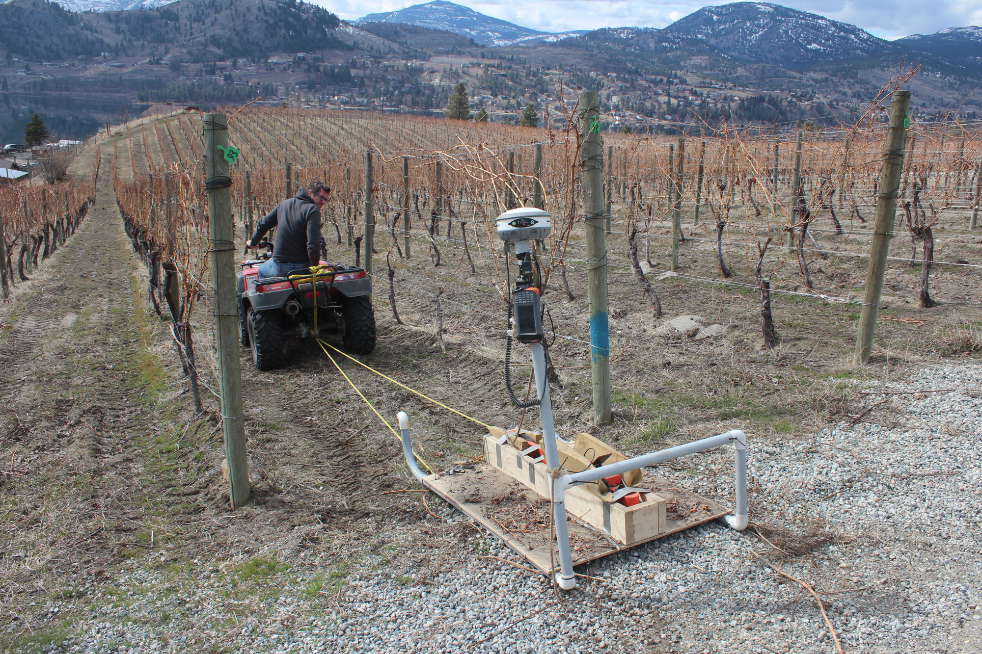
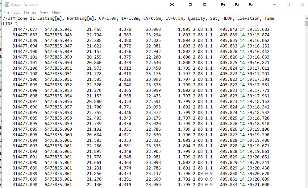
The last setup we used (when we rented our equipment) was a data logger (Archer) connected to a EM38 (our survey tool) and GPS (a Hemisphere). You can see the setup in two photos at the bottom. A program in the data logger collects the data from the EM38 with GPS info and outputs it in a format you can see in the photo below.
Just as an FYI, the EM38 is doing an electrical conductivity survey which is why we can’t have any metal on the sled- it’s all wood, glue, zap straps and PVC. We’ve now purchased new equipment instead of renting and it’s all bluetooth which gets rid of the wires and lets us put the data logger and GPS on the ATV.
We’re taking readings at 10 per second with the EM38 and get a GPS point with each reading.
Will the Reach rover/base work with this setup? The data logger will connect to the EM38 via bluetooth, I assume that the data logger (now an Xplore B10 Windows tablet) will be able to connect to the Reach via bluetooth, wifi or wired?
In the rented setup below, we just turned on the GPS and plugged it into the data logger, turned on the data collection program for the EM38 and we were good to go. Will it be pretty much that simple with the Reach or have I made flawed assumptions?
Reach can output coordinates with 10Hz frequency as well.
On Windows tablet, you can access ReachView using any browser. All you need is to connect your tablet to Reach hotspot and enter 192.168.42.1 in the address bar.
As for integration with a 3d-party app, as @RyanJMcGowan mentioned above, it’ll work with Reach in case this app can accept NMEA over BT.
I’d also recommend using Reach RS2 in such environmental conditions.
Could you please clarify whether you want to use another Reach as a local base or get corrections from NTRIP caster?
In that video its attached to the sled but with our new tech we’ll be attaching it to the back of an ATV (likely on a pole) which should have fewer vibrations. Overall the land is usually fairly flat.
If you mount the Reach RS2 rover on ATV, there should be no issues with vibrations. I think Reach RS2 base and rover setup should work fine for your use-case.
Just wondering how you are doing with Reach for this type of work. I’m doing similar survey work with EM38mkII and trying to decide whether to try switch to a Reach RS+ or even M+
How are you managing working with unknown base station locations in the field or are you able to set up on known points all the time? Otherwise I assume you need to post process your data?
One of the disadvantages I see with Reach over say a hemisphere is the lack of SBAS/DGPS, so that if you lose RTK with the Reach you will need to post-process. How are you finding this?
There are several ways you can figure out the base position:
Post-process logs from the base with RINEX log from the CORS/NTRIP station located in 30 km range after the survey. In that case, you’ll need to process the rover data as well
Mount base on the point, collect logs for a couple of hours and process them before the survey. In that case, you can enter the calculated in PPK base position in ReachView app and collect points in RTK
May I ask you to describe environmental conditions in which you want to use Reach receivers? If Reach RS+ has a clear sky view 30 degrees above the horizon, there should be no issues with maintaining fix.
I was really just interested to see how things were running for @intenna
Essentially it is the same setup as @intenna i.e. carrying out geophysical surveys following regularly spaced AB lines on agricultural land.
More often than not the sites would not be visited beforehand to survey a fixed point as this is often not practical due to time and cost. The time this would take could often be enough to complete the fully survey for example. Often there may be poor cell coverage to receive NTRIP corrections which is what I was refer to when I mentioned losing RTK rather than a base/receiver setup (sorry that wasn’t clear).
Often DGPS is good enough for this type of work (unless (1) you’re doing high density work or (2) want to collect elevation data) so I guess my point is that not in every instance will you want or need RTK which is where having the ability to utilise SBAS in realtime would be advantageous and would save the need to post-process data which just adds another step.
Hi @arageo happy to chat and share as this is a learning experience for us too.
We’re conducting a couple surveys next week with the reach and will update then. Hopefully it works great!
I’m terms of SBAS one thing we learned is that we won’t have SBAS cover where we’re working. Apparently only a specific number of areas in the USA do, per a chat with hemisphere. With them we were looking at their Atlas service or a same base/Rover setup (and more expensive than RS2).
Because we don’t care about absolute position, only relative position within the property, my understanding is RTK should give us more than enough accuracy.
And as you mentioned NTRIPS isn’t feasible (never mind that where we’re working I don’t think we have coverage).
You’ll probably find the RS BASE & ROVER will serve just fine and better accuracy. If you find your in and under tree canopy a lot, then look into the new RS2 setup or you’ll probably find the float accuracy of the RS to be fine also.