Hi, I have setup my RS2 (v2.20.5) in a stationary location using UNAVCO ntrip source for RTK. I am getting fixes on 2 different coordinates, spaced roughly 1M apart. Receiver fixes on one or the other coordinates after reboot. I have tried with the two nearest UNAVCO sources (13km and 30km), getting a total of 3 fixes. (2 fixes per each ntrip source)
This is disturbing to me, and I am wondering how this is possible? I haven’t tried PPK yet, but I was under the impression that if you get a fix, it should be quite repeatable.
What is the other station you are connecting to? Your description of a different fix at reboot is strange. You could start with a slightly higher elevation mask say 15. That low could have introduced some poor data leading to some false fixes when using fix and hold from an RTK perspective.
From an NTRIP perspective check with UNAVCO if any system maintenance was being done on those two stations and confirm the RTCM3 datum of the base coordinate. To me the 1-meter difference suggests bouncing between NAD83 and IGS08 (WGS84).
Try to PPK to the same two base stations and compare coordinates.
I will do PPK on it as suggested, however would think that RTK should not behave this way. It seems to wander over to one point or the other after initialization. I did have a higher elev mask, but lowered to see if it would make a difference.
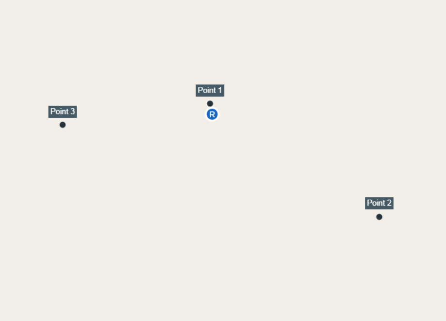
Point 1 is the shared location
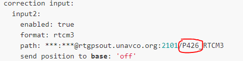
Point 2 is the second fix from the 13km baseline station P426
Point 3 is the second fix from the 30km baseline station P437
Hi Tim ! although I still do not receive my RS2 I see the configuration wrong!
Glonass Ar off, turn off output correction, mask 15 degrees and SNR 45.
If the coordinates of the base are in NAD 83, it will surely have differences to the WGS84 frame.
I would say that you correctly configure NTRIP and the rest of the RTK parameters
Interesting, I see apparently there is a discrepancy between coordinate systems with UNAVCO ntrip and Emlid. Seems like that would result in a consistent offset, but I wouldn’t argue that it could result in an unstable fix. That seems like a problem. Maybe Emlid could consider supporting multiple coordinate systems.
Thanks Luis, I tried again with elevation mask 15, snr mask 40 (as high as it goes), there is no option in RS2 for AR mode, and it doesn’t report AR in this firmware yet.
Didn’t change my problem though. Could be a NAD83 vs WGS84 issue.
Yes of course. But no timeframe on that. It may also complicate things for “most” users… probably why the stalling… yet it is VERY important for users who NEED it and understand the NEED for it. Therefore, just use third party software in the meantime.
Hi @tatiana.andreeva I can send you logs if you really want them, however it seems clear to me after further investigation that the WGS84 vs IGS08 coordinate system problem brought up by several in this thread is the real problem. UNAVCO as an ntrip source is very convenient for me and many others I presume, and it would be of great benefit for Emlid to implement support for other common coordinate systems such as the IGS08 and NAD83 which both use the GRS80 ellipsoid. Many ntrip sources are also on local coordinates, so a whole package would be wonderful!
I am not familiar with the details of RTCM3 but if the ntrip data indicates which coordinate system is used for base location, perhaps in the meantime emlid could consider a warning about incompatible data source.
I am now testing with FieldGenius, using it to interface with the ntrip source for RTK and have had good success with quick fixes and high precision. I will be testing further, but it seems this is my best solution currently.
I was hoping to use the RS2 with RTK via ntrip over cell network, with position output to my ipad or iphone for use with Arcgis collector. This is obviously not possible currently for several reasons. (no Apple MFi for bluetooth)
The RS2 is too good to leave us without these features, so hoping you see the value to us and make it possible!
IGS08 is the latest realization of WGS84. Reach does not know the difference. UNAVCO/PBO should be IGS08. Most stations broadcast GPS only and some GLO. Looks like these stations are GPS only so GLO would have no affect. If base is broadcasting NAD83 your survey will technically be in NAD83 but will tell you its WGS84…
It may or may not be WGS84 vs NAD83 issue. Drop GLO, adjust SNR/Elevation, and change from fix-hold to continuous. Still try PPK to see if can reproduce results.