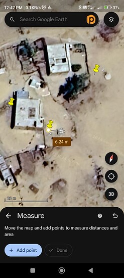
I collect this 3 point in emlid reach rx with fixed rtk but there are almost this work in 6 meter away for actual location. Why? Please give me solution.
Are you saying in comparison to the background map? Google Earth has a positional accuracy of about 1m at best and closer to 2-3m in most regions, worse in others.
To build onto this, in dense urban areas, exactitude is often very good but in rural settings, it can get horribly poor.
Never base your verification on public aerial imagery.
Give me suggestions which map I use? For clearty.
I think this is problem in location. Not in Google map.
I’m not expert in this field please tell me how to fixed this.
The screenshot you are showing is from Google. Finding an online mapping service that matches the specifics of your CRS with any transformations that may be happening is going to be a tough task. GIS software is your best bet and that may still require some learned expertise to localize the map to your specific dataset.
Not familiar with the RX methods, but did you possibly make the mistake of collecting points in SINGLE (autonomous mode?) Then the point will be off by a few to several meters. You need to get corrections from a NTRIP network or a KNOWN POINT for cm accuracy.
Is the issue you experience ONLY with point 3? I notice in the image that points 1 & 2 do not seem to have a differed measurement
What were your occupation times for each point ? Usually we occupy at least 30 sec, many times if it’s an important point at least 5 min using radio RTK or RTN.
I collect these 3 point from rx and turn it into kml. But location show 6 meter away from actual position.
I use global crs. What I do?
Problem with every point
Bro I collect point from fix mode. With mm accuracy. I use cors network. But position show 6 meter away from my actual location. Everytime when I use
Are the errors an offset in the same direction?
A repeatable error usually indicates you have some mismatch in your CRS.
Or that the background ortho is poorly rectified. It’s still my opinion that this is the most likely.
None. Don’t use imagery. If you want to verify your work, tie into a geodetic network. If there is none decently close to where you are located, you’ll need more than an RX to do the work properly. You would need a GNSS receiver that records raw observation data to post-process into your own semi-permanent monument.
Hi, @narendrakparmar082, welcome to the community!
I agree with the other user’s suggestion to try another background map. We also have this support tip on how to add an orthomosaic map in Emlid Flow.
Additionally, do you have any benchmarks nearby? It will be helpful to test it with it.
This topic was automatically closed 100 days after the last reply. New replies are no longer allowed.


