First off, this is my first post, and im a fairly new user to Reach. Quick up to speed, I have two reach modules(base/rover setup),both are up to date on all firmwares/softwares/reachview/etc. I get base corrections from a local service. I gather data at my base station to set a known location. I disconnect corrections and enter those coords manually. I broadcast base correction via 3dr to my rover. I walk my area to be surveyed. Gather data via raw logs. I successfully plot data in rtkplot.
Now, my question is, and this might be a total newbie question, but how can i pull elevation data from that rtkplot? Or, how do i pull “said” points from rtkplot and place them in qgis to overlay my geotiff basemap? So pretty much im looking to extract my “track” from rtkplot and then contour a basemap with that data(must contain elevations)
Is this even the correct approach or possible for creating a contour map?
Or will i have to set up some sort of grid and stake points?
Believe me, i am NOT a surveyor HAHA. Please even advise how you would tackle a 12acre property. As stated above i do have an Inspire1 to aide if needed for a basemap. What is a proper procedure to even contour a 12acre property?
Use your reach as you describe to set up a series of ground control points. These should be on the ground visible from the air (big target circles) and you should position them. Because you are doing your precise positioning post priori. I.e. you and doing PPK. then survey mode won’t help.
Go round the property visit each GCP and spend atleast a minute at each GCP (note the occupation time in a notebook)
Go home process all the data kinematically to create your track (use the tutorial)
You mentioned QGIS. So load the .pos file from processing into QGIS using delimited text. At each of your GCPS you will see a little cloud of points (you can select these by time in the attibute table) select these and average them. the attributes containt the spheroidal height.
In the past have used the “survey mode” and gathered numerous points. I then loaded then onto excel to create a spreadsheet of those coordinates. I then added those to QGIS and used the contour plugin. It contours my map but doesn’t always link the elevations smoothly and/or correctly(meaning it may just link points to points and skip over a not really show a real curvature because of how it linked the points. It’s usable I spend some time adding “virtual” points to clean up the contours.
Is there a better way to contour? Again, I have no training but what I’ve taught myself in QGIS. So maybe there’s a better/easier way???
I have used GCPs in the past to help align my drones base map, no issues here. But, when using the DEM produced by MME to contour the map the elevations are off or not always correct in certain locations when checked against Reach for fun on the side.
Is there an easier way to contour my drones base map with the Reach and not use the DEM produced from my base map?
If all else fails, it’s my uncles property and I will walk the 12acres and take 100+ points(or whatever it takes) making sure to hit good locations that show elevation changes.
I do have a “base map” from the county auditor of his property from 2016, contours and all. BUT, we/he has done some dozer/grade work in about half the area, so we know for sure the lay of the land had changed.
So again, how would you go about contouring this 12acre property?
Side note, yes I know that Reach is Ellipsoid and how to get a proper conversion, thanks.
I think it would take many points to end up with smooth contours. Simon is perhaps suggesting taking aerial photographs? Maybe this is more than you want to do, but you could get into a dji P3A or P3P for a relatively small investment. Or maybe you could find someone close to you that could do this for you. For example, I would be happy to do this for you if you were near me. For 12 acres it would take less than 30 minutes to plan and fly the recording session.
Combined with your GCPs you would be able to get an accurate orthomosaic (geo-tiff) that you can very easily bring into QGIS as a DEM and add contours and shading. Whatever SFM solution you use to generate the geotiff will make all the extrapolations in elevation for you. If there is heavy vegetation then it would take some work post processing to clean up for elevation before generating the final geotiff.
Anyway, Here is a link to a tutorial on bringing the geotiff into QGIS and generating contours and shading.
I have done many aerial maps but none using GCPs, i thought GCPs for aerial use would only help align the image for post process, not help with contouring. My early days of “mapping” consisted of taking what Maps Made Easy has given me and called it good because it was all for fun and elevations from their DEMs were good enough.
Well fast forward about 5yrs to today. I have the equipment(2 reach modules), and I still have my Inspire1. I am very familiar with the Maps Made Easy app, and their website work flow. I will go into the field and get GCPs, and then post process them in QGIS against the MapsMadeEasy DEM to get the contouring close. Usually the probelm is that when i adjust the DEM numbers via the Raster Calculator for one point to get close to the contour, another point elsewhere doesnt match up.
I really wish i had someone close to show me some tricks in post processing to get things to line up.
Contouring depends on accurate Z #'s. Good GCP’s should also make vertical calculations more accurate. So there should in theory be less adjustment needed in QGIS than when not using ground control.
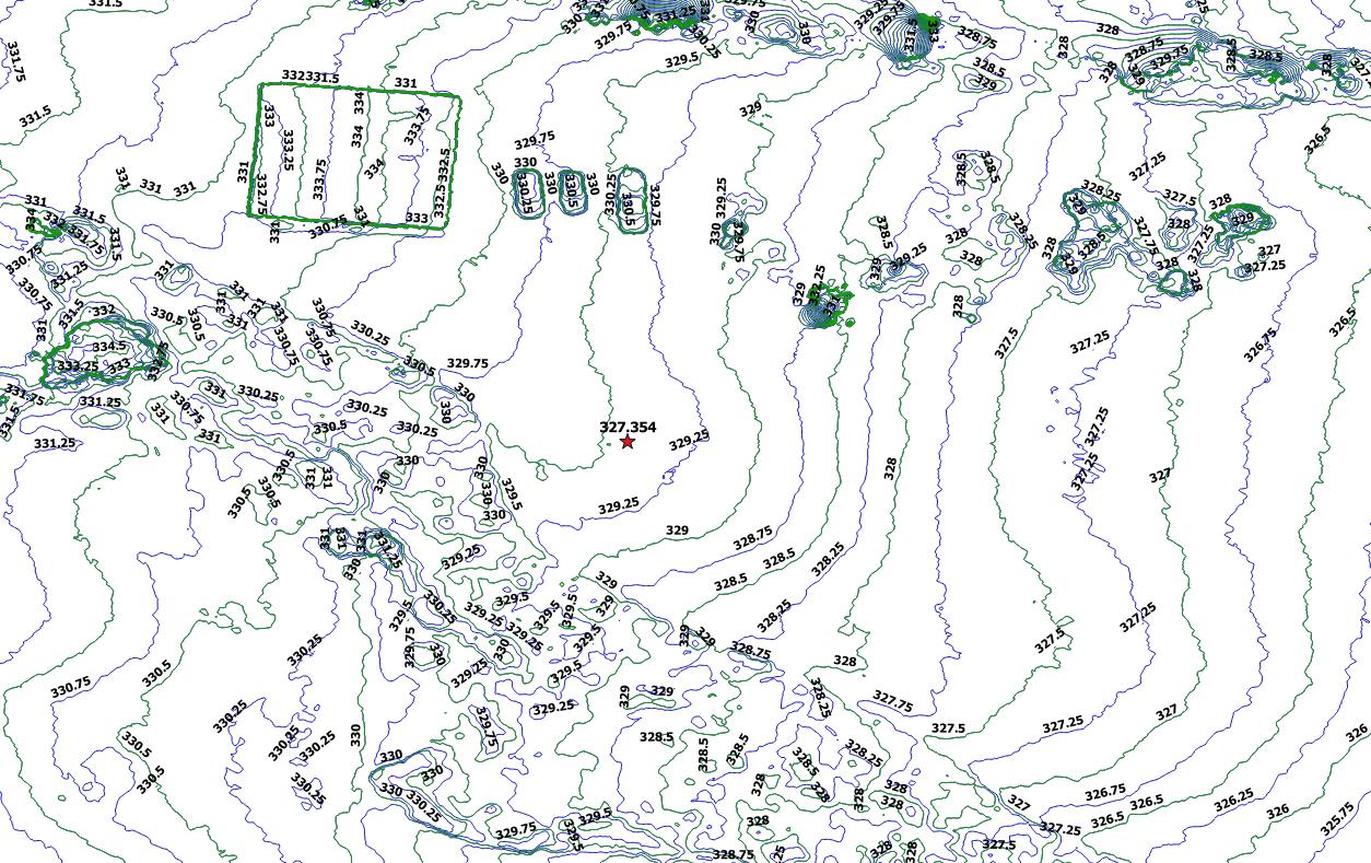
Here is a test i just did. I used MapsMadeEasy for my aerial “map”. I then download the DEM and opened it in QGIS. I then loaded control point(Red Star, a 30mins base average, then adjusted ellipsoid) into QGIS. I then contoured the DEM via Raster>Extraction>Contour=>Set as every .25m.
You can see that my control point(middle of page, red star) is in between 329.25 and 329.5 BUT its 327.354.
I will try to get back out today to gather more points, all i had time for this morning was to gather a 30min base mark.
Hopefully more points will help me adjust the QGIS contour numbers
NOTE: My single control point/base mark was not used in the MapsMadeEasy processing. It was only added on top of the MapsMadeEasy DEM in the QGIS program to verify/check accuracy.
I would try and input the GCPs into MME or whatever SFM solution you use when creating the geotiff rather than try to apply the correction in QGIS. But again, that is just my understanding and not from experience.
I would suggest introducing your ground control points already in the mapsmadeeasy process. I think that it is the same price and then your raster DEM should be ready for making contour lines without additional processing in QGIS. I am very interested in all the details of your procedure and consider myself a beginner to immediate who has dabbled in many aspects of the uav to 3d model and contours, etc. I was wondering how to sort of smooth the contour lines in qgis?
Aahh, well.
From MME download the point cloud and open it in Cloud Compare.
might be an issue with the MME pointcloud if it is in geographical coordinates, you might need to convert to UTM, NAD, or whatever.
Run a noise filter over the data
resample at a regular interval
Use the ground detection algorithm to try and filter out the trees and buildings.
You could block shift the whole cloud to fit your reference elevation
then create DEM or contours in CC
Well Simon, I appreciate your info and how to correct issues, but unfortunately for now this is still way over my head. I am an RC hobbiest that has taught myself everything. So all the post process stuff is VERY foreign to me with no having any backing in “GIS” software or schooling of any sort. I am currently not a business owner, but would like to iron out issues now and look at possibilities in the future.
I will try to get back out on Friday to gather more GCPs, and add them to MapsMadeEasy BEFORE processing.
Maps Made Easy with GCP’s is a great way to go and I love their attitude of free small jobs! It is amazing what you can do with 100 photos.
Try downloading the point cloud (las) file afterwards and download the open source Cloud Compare to view it, That;s the first step.
@Simon_Allen It’s good to have an expert opinion on MME. I have always felt like they make it possible for guys to get started with few to no software expenses.I also really like their flight planning software but it only runs on iOS. It is the only one that has given me good results with DJI mavic pro. @DaneGer21 Yes, Pix4d desktop trial version will handle ground control points nicely as well. Pix4D is much different software than MME. It is installed and processes your info on your computer so you don’t need internet connection. MME is more like DroneDeploy. You upload your images and work online. One thing MME does not store your data indefinitely like DroneDeploy. The fastest processing I’ve seen is Pix4D cloud version. But both DroneDeploy and PIX4D need a payment for ground control points. MME allows free ground control points up to 100 images. Here is their pricing.
Also, I am in no way affilitiated with them. In fact, I was told by them a year or two ago that it was impossible to have high accuracy survey equipment for under ten to twenty thousand dollars.
The real reason I’m trying to get this squared away is because my boss asked me to map a 130acre plot of our work area where we have stripped topsoil and peat moss and needs to know elevations(showing contours) to present to our local Army Corp for water shed/holdings. The area is one of the lowest in the surrounding areas and floods in the off season(we pump dry to excavate). So essentially they want to know elevations to see how much we have changed that.