Coming from Trimble Access, I have a few suggestions for the app.
First one : Key in coordinates
If I am in the field without a csv file and need to stake out a point, I would like to be able to key in the coordinates of a single point or a couple of points without a csv created before in the office.
EDIT : I found it, it is already in Flow.
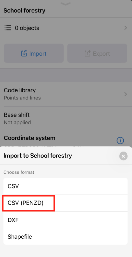
Second suggestion : Import CSV file without header.
I am used to generating a csv file without header with only PENZD. Could you make like some software an import function that count the first line as the first point and you tick the option “ignore first X lines” when headers are used ?
Also for entering coordinates for base position, it would be interesting to import coordinates from a csv file or choose an already imported point.
In Emlid Flow, you can import CSV (PENZD) where the columns shouldn’t have a header. Did you have a chance to try it?
As you mentioned, it’s also possible to add points by typing in their coordinates. manually.
Regarding the base position, it’s possible to configure it with an already-created point by choosing a point from any project. You can find the necessary steps for it in this Support tip.
Feel free to share your experience with any of these tools!
I have another suggestions:
When using the EMLID caster with a base manually a known point, insted of saying single, could it say manual and also the mount point its using. Managing multiple teams uaing this resources, seems a little hard to keep track on whos whos. Also, it would be neat instead on expresing the number or rovers connected, i would like to see what mp the rover is getting the corrections from. For the same reasons express above.
Thank you for the feature requests! I’ll register them and pass them on to the team for consideration.
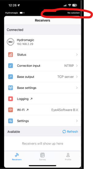
Where exactly would you like to see this information? In Emlid Flow or Emlid Caster? For now, it’s possible to check the base configuration method under Base settings in Emlid Flow.
This is somewhat confusing. Perhaps you can clarify a bit.
If a gnss unit is acting as the BASE and broadcasting via Emlid Caster, it is not receiving anything from any mount point.
If the gnss unit is acting as the ROVER and receiving corrections via Emlid Caster, it will display FIX (or FLOAT), not SINGLE.
You mentioned that you’d like to see the name of the mount point to which the rovers are connected. You can now check it in the NTRIP profile under Correction input.
Can you please elaborate on this? You mentioned that it’d be useful to track the different rovers. Are there other purposes for which you’d like to use it? I’d like to make sure that I register your request properly.
The feature request is for the ability to see on the status bar or panel, what Caster mount point is using and what coordinates the base is using to send corrections. Also, instead of just saying “single” it could be “manual” if the base is in a predefined location. It would be nice to see the same information unit is in rover mode. I am often remoting our crews’ devices to ensure their base-rover setup is correctly configured. That means I have to jump from one unit to the other verifying that information, instead of just verifying the information in one device. It would be even better to have the ability to create profiles for the base outputs too.
I don’t know about others, but we’ve grown very accustomed to seeing the offsets from our position to a staking position. I’d love to see a toggle that would change the staking prompts from azimuth and distance to delta northing and delta easting.
Hello. I have something more challenging to suggest. How about IMU logging so that we can do PPK with tilt enabled in emlid studio. A lot of times we have problems with cellular or base being far away so we have to use PPK, having the tilt ability will boost the efficiency of the survey!
@avelez, thanks for the further description. I’ve registered your request and passed it on to our team for consideration.
@samclarkps, I can agree with Wombo, as there’s an option to switch between staking out by direction and distance. Or would you like to work with it in another way?
@Vdim, hi! The tilt compensation requires a FIX solution in real-time. Therefore, it can’t be used for PPK processes.