As I plan to use M2 in production soon, is there a chance this issue will be addressed ?
Is it possible at least than a developper check the code and tell which constant should be applied to correct height ?
I will be glad to help on this point, but I learned that Reachview code is unfortunately no longer open source (I didn’t even find rtklib binaries in the filesystem).
We’re currently testing Reach M2 in a setup with RTKNAVI, our local NTRIP caster, and different antennas. We’ll try to provide you with a solution to this issue as soon as possible.
I’ve collected points with Reach M2 and 2 different NTRIP casters in RTK and processed the logs for the same time periods in PPK. The results in RTK and PPK differ by about 1 cm. So, it seems that the ReachView app and our version of RTKLib work fine.
As Igor said, the setup is rather complicated. The offset can relate to your NTRIP caster settings or may appear due to the RTKNAVI settings.
May I ask you to provide me with the raw rover data, RTCM3 file, and the precise base station coordinates? It will help to check if your RTK result differs from the PPK one.
Which antennas did you declare for your rover and base for your PPK processing ?
Do you mean the raw satellites data generated by rover and base during RTK ?
I’m not sure Reachview can record these data. If yes please tell me how. Otherwise I will activate the base mode on the M2 rover and try to catch both NTRIP caster and M2 on the network.
I did two RTK static sessions and files are downloadable here :
The SPAU directory contains observation with SPAU station (from local permanent stations network) as base. Its geocentric coordinates are 3392767.5400,4896876.2795,-2270642.6099
The SLEU directory contains observation with SLEU station as base, from the same network. Its geocentric coordinates are 3387826.3009,4890457.7400,-2291647.3150
The M2 antenna is a Leica LEIAX1202GG (L1 : 63.4 mm ; L2 : 62.1 mm). Pole height is zero. Antenna stayed on the same point during whole session, whose theoretical coordinates are :
Is there some progress about this issue ?
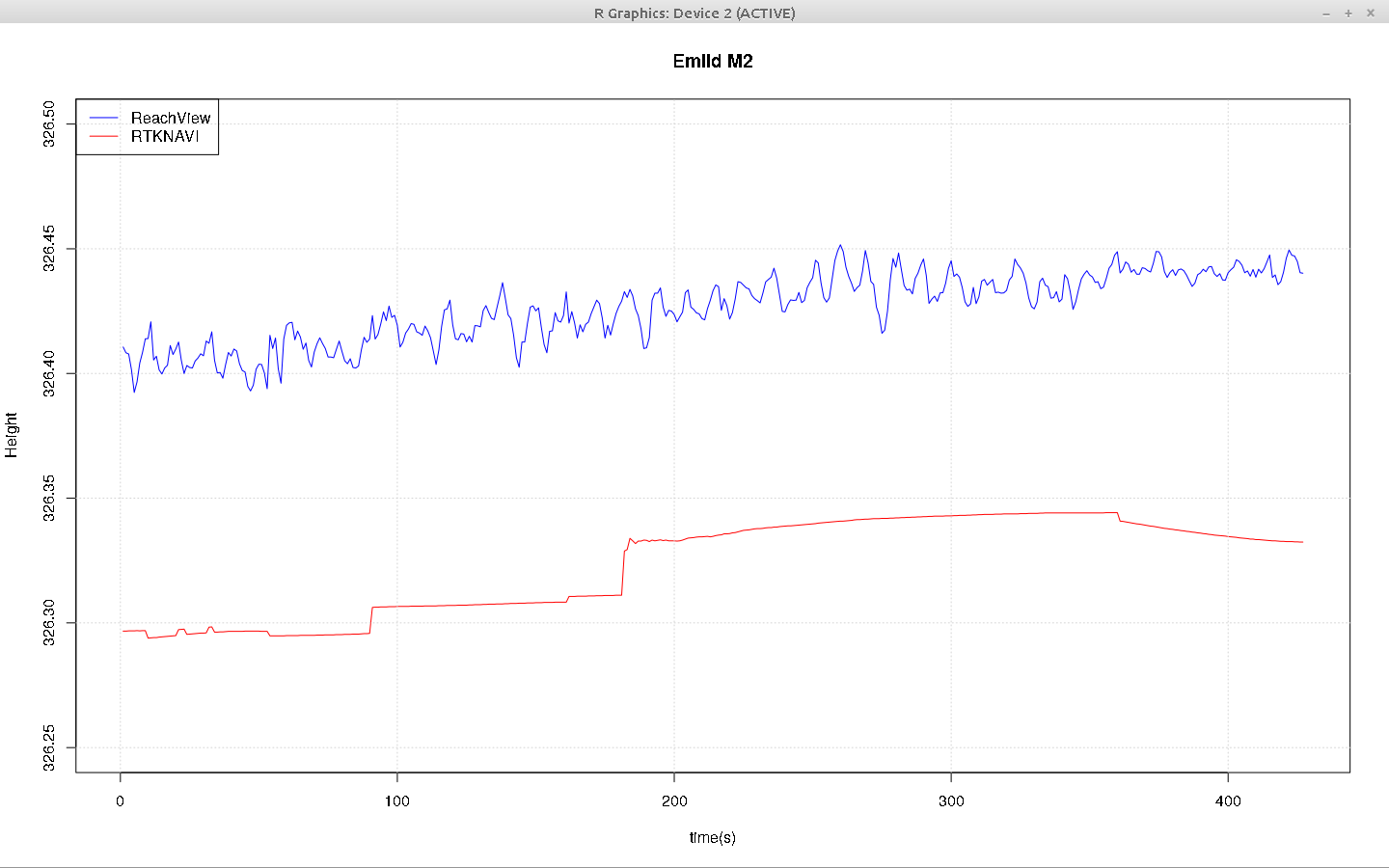
I did other tests with a slightly different protocol : I run simultaneously Reachview and RTKNAVI, with the latter using raw UBX data directly from the board. There is a nearly constant shift of 10 cm between the 2 softwares.
If I declare the actual antenna (LEIAX1202GG) in RTKNAVI, the shift is 16 cm.
Other users have experimented the same issue : @mheyer (this post, 10-15 cm) and @Gianpaolo, who observed a 4.5 cm shift between ReachView and RTKNAVI, using an M2 and Leica AR25 antenna.
Sorry for the delayed reply. Is there any chance you can download raw RINEX files from your NTRIP caster? We believe it might contain some additional info that the RTCM3 log from Reach doesn’t have.
For now, with all our tests, it’s still hard to draw any conclusion. It seems that we should pay more attention to this exact NTRIP caster data.
I suppose you wish to compare RTK and PPR results. For downloaded RINEX files you should take into account the base antenna type, which is a LEIAR10 (it is declared in the RINEX header).
Base corrections received in real time are slightly different than downloaded RINEX files. The provider explained me that broadcast (RTK) corrections are adjusted for a theoretical base NULL antenna. So customers don’t have to configure a base antenna in their rovers while doing RTK surveys. And indeed the antenna is declared as null in RTCM3 received files.
As I understand the second part of your post, you did a post processing with broadcast corrections with LEIAR10 antenna for the base. This explains the difference (LEIAR10 has a 8.8cm phase center offset). Try the same with a null antenna.
It’s a Reunion Island provider named Precision topo, and the network is Reseau Lel@. They use Leica devices and softwares (Leica GNSS Spider). Furthermore, SLEU station is part of french national geodetic network (rgp.ign.fr).
What it is interesting to note is that I have the same results with RTK with RTKNAVI, and post processing with either broadcast corrections or downloaded RINEX. And the results match benchmark known height.
Only Reachview gives a nearly constant +15cm elevation, so there should be something wrong in the code with antenna height. I will be glade to help to review the source code if it could be made available.
Do you also possess a M2 ? I will be interested to share observations to try to understand this issue.
No, RS2 user.
What I am wondering, given that 14-15 cm is so close to the 13,4 cm antenna height of the RS2, could that be hidden variable somewhere, that is added in error?
BTW, I processed the your rover data with all the available stations on the island (man, I envy that density for a public network!) and did a network adjustment, resulting ellipsoid height is 326.299, stdev H 0.004 m
Yes I think the M2 is internally configured for the UAV mapping kit, with a RS2 antenna on base (offset 13.4 cm) and a Reach GNSS antenna on rover (offset 3.5 cm).
So rover height is calculated this way (assuming pole heights = 0) :
Zrover = Zbase + 13.4 + dZ - 3.5
but as I use a NULL antenna on base (offset 0) and a LEIAX1202GG on rover (offset 6.34), it should be calculated this way :
Z = Zbase + 0 + dZ - 6.34
So the difference is :
Zr - Z = 13.4 - 3.5 + 6.34 = 16.24 cm
This match my latest observations with a dual RTK measurement RTKNAVI / Reachview, where I found a 16 cm shift.
Excellent ! It’s exactly the benchmark height, calculated from many hours of observations with Leica GNSS receivers.