


Hello,
I recently received a Reach M2 and began testing it on a known benchmark with a LEIAX1202GG antenna.
The unit is impressive : getting fix is very fast, and the dispersion around mean is very low : With a cumulated 3 hours of logs, 95% of measurement are within 1.5 cm in horizontal distance and 4 cm vertically.
Nevertheless, there is a significant systematic error with the actual coordinates of the benchmark : 0 cm X, 2 cm Y and 15.6 cm Z.
This error is produced by the fact that antenna parameters could not be declared in Reachview, so they are not taken into account. Indeed with a post processing of raw data with antenna parameters, I get an accuracy of 1.7 cm XY and 2.2 cm Z.
So could it be possible to add antenna values in RTK settings in Reachview ? In the meantime, is there in the M2 filesystem a configuration file which could be edited ?
Regards
Pierre
Hi @zipang,
I guess you can simply add the antenna parameters to antenna height in the Survey project. Please try this and tell me about the results.
Also, it’d be interesting to take a look at your logs. Would you mind sharing them? You can send it on support@emlid.com if it contains some sensitive information.
As far as I know, phase offsets are not simple vertical correction. By the way, as their main component is vertical, the two are close.
For example the antenna I use has the folloming ENH offsets (mm) :
L1 : 1.6 -0.5 63.4
L2 : -1.2 0.2 62.1
If I post process the M2 data with and without antenna file, I’ve got an altitude difference of 63 mm, which is practically identical to L1 or L2 phase offset vertical component.
This doesn’t match the 15 cm error in averaged RTK values, so may be there is already within the software another parameter for base/rover antennas.
Svetlana what kind of log do yo need for analyse ? For now I have only the solution log.
Hi @zipang,
I got you. Thanks for the feature request. We may consider adding this functionality.
Usually, phase offset center values are just in several millimeters, so it doesn’t affect the accuracy a lot, and it stays within the normal range.
Svetlana what kind of log do yo need for analyse ? For now I have only the solution log.
If you have the RTK solution log, please share it with me.
Hello Sveltana
If you have the RTK solution log, please share it with me.
Here are the first lines, they are nearly all the same :
2020/08/21 07:27:47.000   3393645.3388   4894086.6924  -2276173.8496   1  21   0.0009   0.0163   0.0057   0.0000   0.0000   0.0000   1.00    0.0
2020/08/21 07:27:48.000   3393645.3388   4894086.6901  -2276173.8478   1  21   0.0009   0.0163   0.0057   0.0000   0.0000   0.0000   1.00    0.0
2020/08/21 07:27:49.000   3393645.3404   4894086.6913  -2276173.8473   1  21   0.0009   0.0163   0.0057   0.0000   0.0000   0.0000   1.00    0.0
2020/08/21 07:27:50.000   3393645.3405   4894086.6920  -2276173.8467   1  21   0.0009   0.0163   0.0057   0.0000   0.0000   0.0000   1.00    0.0
2020/08/21 07:27:51.000   3393645.3393   4894086.6910  -2276173.8459   1  21   0.0009   0.0163   0.0057   0.0000   0.0000   0.0000   1.00    0.0
It doesn’t seem there is anything relevant…
Hi @zipang,
I’m afraid it’s hard to understand something from a log’s fragment. Could you please share the whole log with me?
Hello Sveltana
Here is a whole log :
solution_202008210727.XYZ.zip (24.6 KB)
But I don’t think you will find anything interesting, there isn’t any antenna information.
Usually, phase offset center values are just in several millimeters, so it doesn’t affect the accuracy a lot, and it stays within the normal range.
It was true for Emlid single frequency receiver, but the M2 is far more accurate and you can except an height error lower than offset antenna (some have up to 14 cm offsets).
I did a post processing with the M2 on a benchmark, with antenna offstet taken into account, and I have a Z accuracy of 2 cm.
Hi @zipang,
I’ve seen your other thread regarding RTKNAVI.
You mentioned that you use Reach RS2 as a base. How did you enter the base’s coordinates in the ReachView app? Please make sure you’ve added 13.4 cm to the base’s height. I guess that might be a point.
Hi Svetlana,
You mentioned that you use Reach RS2 as a base
Absolutely not (may be my english is inaccurate). I use an NTRIP caster.
I said that may be for M2 Reachview is configured by default with RS2 as base, and this could cause the error.
Hello,
So I finally suceeded to use Reachview and RTKNAVI simultaneously with the M2.
Here are Reachview windows with an extract of RTKNAVI window (the red square) at exactly the same time.
Test characteristics :
Base : NTRIP Caster with NULLANTENNA
Rover : Emlid Reach M2 with LEIAX1202GG Antenna
RTK fix with GPS sat only, L1+L2
Benchmark ellipsoidal height : 326.31m
First screenshot :
RTKNAVI antenna config : Base : NONE / Rover : LEIAX1202GG
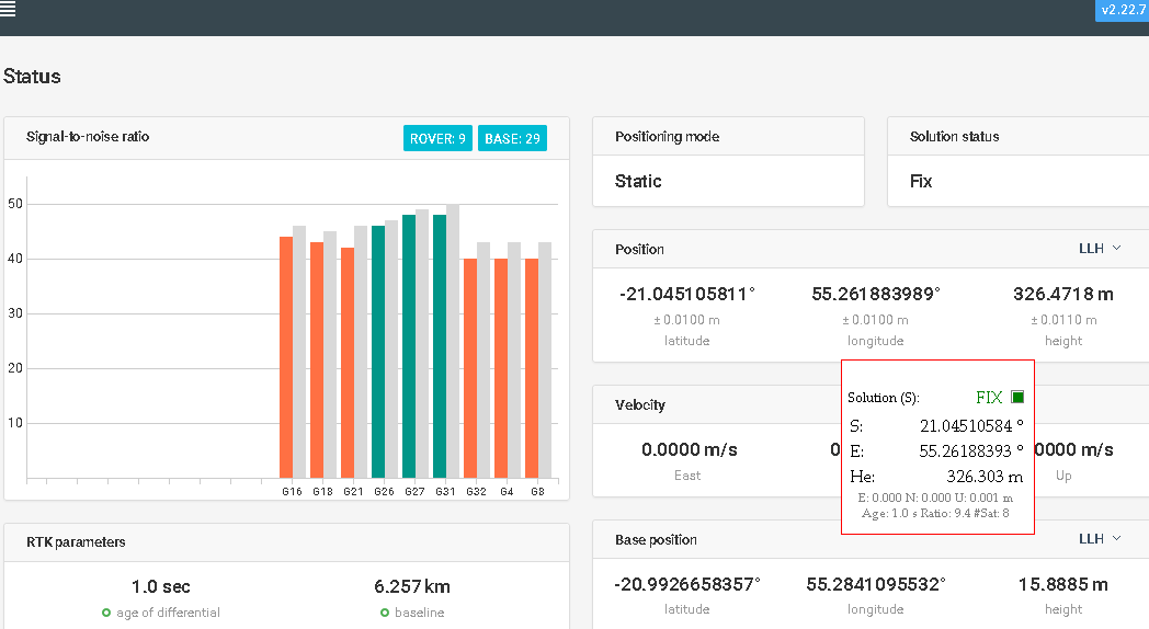
→ Horizontal position are nearly identical (6 mm), but Reachview height is 17 cm above RTKNAVI Height. The later is very close to benchmark height (1 cm).
Second screenshot :
As Reach M2 is sold in kit with Reach RS2, my hypothesis for this difference is that RS2 antenna parameters are internally declared for base station in Reachview for M2. So I tried to mimic this behaviour with RTKNAVI, using a STXS10SX017A antenna, whose characteristics are close to RS2 :
RTKNAVI antenna config : Base : STXS10SX017A / Rover : NONE
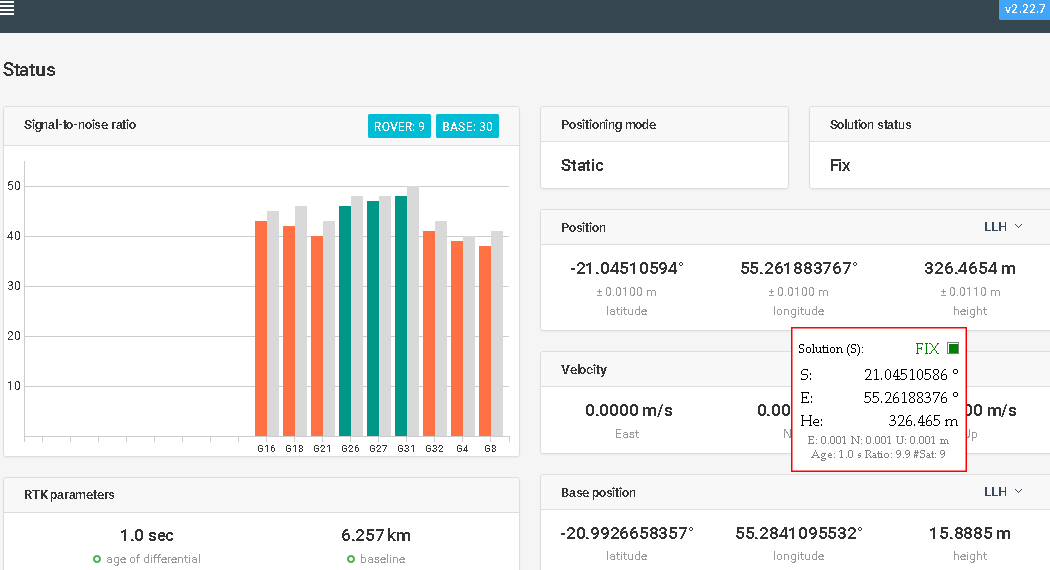
→ RTKNAVI and Reachview heights are now identical.
Is there an Emlid developer here which could confirm or comment ?
Hi Pierre,
Thanks for the detailed description! It looks interesting.
Any chance you can try to use RTKNAVI without applying any antenna configs? Just to check the difference of the coordinates in this case.
Here are results with various antenna configurations. Height have been averaged during secified time.
RTKNAVI Antennas base / rover : NONE / NONE
Duration : 38 min
RTKNAVI height : 326.33 m
Reachview height : 326.42 m
Difference : 0.09 m
RTKNAVI Antennas base / rover : STXS10SX017A / NONE
Duration : 29 min
RTKNAVI height : 326.47 m
Reachview height : 326.45 m
Difference : 0.03 m
RTKNAVI Antennas base / rover : NONE / LEIAX1202GG
Duration : 40 min
RTKNAVI height : 326.25 m
Reachview height : 326.44 m
Difference : 0.19 m
Adding antenna configurations to Reachview will allow M2 to compete with far costier survey grade receiver…
Hi Pierre,
Thanks for testing! We’re going to conduct the same tests with our antenna as well to find out the root of this discrepancy. I’ll keep you posted.
Yes, I understand your point. However, it’s not easy to implement, so we need to discuss it with the team.
There are no assumptions made in ReachView about the base antenna. We simply take the elevation that the base station provides in the RTCM3 message 1006. This is completely in line with the standard. No extra offsets are applied.
When configuring a survey project you need to enter antenna height of the rover, which is pole or tripod height + bottom of antenna to phase center offset. In your case it is pole height + 63.4 mm.
The height that you are seeing on the ReachView Status page is of the rover antenna phase center, so when compared to RTKNAVI solution, where antenna offset is added it is clear that there will be a discrepancy. Adding RTKNAVI to the mix significantly complicates the setup and debug as there are many places where offsets could arise.
Could you please make a drawing of your setup? Where do you enter which offsets? How are the heights on the base station configured?
Hi @igor.vereninov , thanks for your answer.
I don’t have a base station. Corrections come from an NTRIP provider. They are computed for a null antenna on base : RTCM3 1008 and 1033 messages declare a GPPNULLANTENNA.
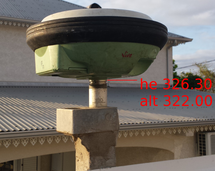
The benchmark is equipped with a thread, so when an antenna is fastened, the mechanical reference plane of the antenna matches the known height of the benchmark (pole length is zero). The ellipsoidal height of this benchmark is 326.30 m.
I use a Leica LEIAX1202GG antenna so the correct configuration for a receiver is :
- Base : null antenna (L1/L2 phases vertical offset = 0)
- Rover : LEIAX1202GG antenna ; phase vertical offsets :
- L1 : 63.4 mm
- L2 : 62.1 mm
These parameters are entered in the options/positions tab of RTKNAVI :
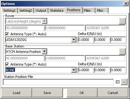
Antennas phase offsets are included in NGS atx and pcv files, declared in options/files tab.
Results are :
Software __| Base/Rover antennas | time | averaged height
RTKNAVI __| NONE/LEIAX1202GG | 40’ _ | 326.25 m
RTKNAVI __| NONE/NONE ________| 38’ _ | 326.33 m
Reachview | NONE/NONE ? _______| 107’ | 326.43 m
RTKNAVI results are consistent with antennas’ declaration.
If Reachview doesn’t use any antenna offset, we should observe a systematic error of +63 mm for the M2/LEIAX1202GG duo. But I did other measures, other days, than the aforementioned, and I observe a systematic error of +15 cm (+/-2cm), I could not explain. It is not related to the M2 receiver, because results are good with RTKNAVI or by post processing raw data.
As Reachview uses RTKLIB algorithms, may be there is something to check in configuration parameters. I tried to check myself, but rtk.conf file is no longer visible in M2 filesystem.
Hi @zipang,
Could you please update to the latest dev and check if the issue with vertical offset goes away?
Hello @igor.vereninov
I did a new test with the lastest dev and there is no change.
An 1h40 test at 1 Hz give a mean height of 326.46, that is 16 cm above true height.
Results are consistent : max difference between measure and mean is 6.6 cm, and 95% of measures are below 3.4 cm of mean.
Where do you observe the 326.46 height? In ReachView status?
What if you try with a different base station or a different benchmark?
What is the positional certainty of this benchmark?
Could you please post a picture of the antenna mounted on the benchmark?
This consistent offset must be coming from somewhere 
The 326.46 height have been averaged from the 6300 observations of the solution file (at 1Hz, fix).
The benchmark is reliable. Its position have been computed from many hours of observations, at different days, with Leica GPS1200 and GS14 receivers, with NTRIP corrections from local provider stations’ network. Here is a picture with a GS14 :
A recent post-processing of nine hours of observations with Emlid M2 gave an height of 326.305 m.
Anyway, even if benchmark known height was false, as I have already said in my previous messages, RTK positions calculated with Reachview are ~15 cm above those calculated at the same time with RTKNAVI. And RTKNAVI positions match benchmark known height.
To said it simply :
- Leica receivers GPS 1200 and GS14 (RTK), Emlid M2 receiver with RTKNAVI and with post processing all give an height of 326.30 m +/-5cm
- Emlid M2 receiver with Reachview gives an height of 326.45 m +/-5cm
As Reachview is the only software where antenna type could not be configured, the obvious hypothesis is that this offset has something to do with antennas.
Hello Zipang, hello Igor,
this ist neither a problem of the Receiver nor of the antenna. It seems Reachview has a Bug.
I also have differences in height between RTK and PPK. I checked it many times in different constellations, ReachRTK+TallysmanTW3710, ReachM2+TW3710, ReachM2+HarxonHX600Helix. In each case I geht a difference of 10 to 15 cm between RTK and PPK. I used high accuracy data of VRS from german SAPOS.