


If you snap a pic with the drone on the ground that will just give you a quick reference of what altitude the images are reporting in comparison to your base.
1 Like
I meant to do that on my last test just forgot. I need to make that part of my normal ops.
3 Likes
Yeah, Pix4D’s interface is a bit confusing as I said above! Glad it’s resolved, I pretty much knew what the problem was but I wasn’t able to articulate my advice fully. ![]()
Thanks Gabriel. I just wasn’t aware that you could set that. I thought you meant setting it in the output coordinate tab.
Now I know who to ask when I hit Pix4d issues ![]()
With the help from you guys and Pix support we got the Geoid offset mystery solved with the EVO and Pix4d mapper. I did 3 more test flights and my elevation is off between 5 - 7 feet, horizontal is off as well but under 1 foot. I can adjust for elevation in the image editor but not horizontal.
I did snap a photo with the m300 and the EVO…basically in the same spot, and they are pretty close. M300 elevation 984.987 EVO 984.522 ellipsoid height, so I would expect them to be pretty close post processing…nope about 6 foot difference, EVO low, M300 under 1/10. I used the same setup for both flights, base setup on a known point correcting via caster. I ran a 3 flight using the correction network, basically the same results elevation off by about 7 feet, horizontal also off under 1 foot.
I also snapped a pic with the evo sitting on the ground right next to a BM the difference in elevation was about 3/10…height above the mark, acceptable given the height of the drone.
I’m not sure this is a Pix issue or Drone issue. Base on the pics on the ground elevation seems to be pretty close, no idea what’s going on with horizontal.
Any advise would be appreciated.
Thanks
5-7ft is sure close to a 2m (6.56ft) rod height… I have never had any of these problems with DroneDeploy or SimActive. Horizontal - Could it be network vs. Localization?
Hey Michael,
Rod height is 1.8m + 134mm (6.345ft) so that might explain that if it was off consistently. I can compensate for that in the image editor from the start but that doesn’t explain horizontal. I flew the site twice with the EVO once using my base and once using the network and actually using the network there should be no rod height compensation so I’m still at a loss.
Can you send me a share so I can download and process? Include the checkpoint file if you can.
Just sent you and email with a link.
Got it.
Just sent an email to download the DroneDeploy processed data. I’ll run SimActive later.
No issues like that in my use. My P4RTK and Evo2 Ent. RTK provide similar results to each other. I don’t use Pix4d, so no help there.
Just ran SimActive and it was within 386cy across the site which means they are less than a 0.10ft overall. I don’t know how any of this will match your data but I did notice that the vertical shift was about 6ft different between DD and SimActive… Hmmm… DD needed to be raised 91.25ft and SimActive had to come up 84.41ft. Like I needed something else to keep me up at night, lol.

The 91.25ft sounds like my original issue where it was off between 80 - 100, the big part of that was cleared up, It’s the 6 - 7 feet off in elevation like what you’re seeing. I can make up for that in the image editor, I’d rather not have to do that, but the horizontal was out as well…not 6 feet but between 4 - 7 tenths.
Guess I’m gonna have to open another ticket with Pix see if they can figure this out. At this point I can’t really use this drone for topos.
I’m not sure what you mean by image editor but the data is what it is. Can you compare what you got to the DD map? I contacted SimActive and DroneDeploy to try and figure out why I am seeing two different vertical adjustments. If you want to send me a link to download your point cloud I can add it to the comp.
Pix4d has an option when you import the images to set the vertical CS, by default it’s set to EGM 96, when importing images from the M300 it automatically sets it to a geoid offset option and sets it to 0 and I set the geoid offset in the output CS. It doesn’t do that automatically for the EVO I set it manually then set the geoid offset the same way. But if I"m off by an additional 6 or 7 feet I can compensate for that in the image vertical cs to make up for that 6 or 7 feet.
Just sent you a link for the point cloud.
Also pinged Pix support again.
1 Like
Just came across this on a new project minutes ago so just throwing it out there. Does the project have a scale factor? If so, how many places did you go out? The plans I am working on call out the standard TXDOT scale of 1.00012 and when I applied it the horizontal was off a couple of feet. I used the drone ortho in CAD to align with property corners and I got 1.00011917 and am now within a tenth. I hate scale factors and the US is built on grid so they need to stop this! Our northing are 10,000,000ft so you have to go out at least 8 places to even have a chance of aligning.
Yeah, scale factors are a pain, and half the time the engineers don’t call it out in the drawings. This one does, typically if it doesn’t line up in Agtek I used the Transform Northing and Easting function yo align it and they usually fixes it. If I know there’s a scale factor, and it’s not called out and if I have the surface and grid coordinates I can figure out what it is.
If that was the case here I would think the M300 would have also been off.
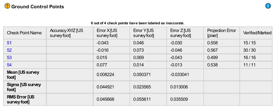
M300
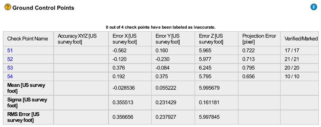
EVO
Pix is looking at this again as well.
I’m not sure how we can compare an M300 w/ P1 to the Evo RTK. IMO Pix4D has some work to do on the camera calibration or there is something else needed in the process that you are doing.
Is the issue consistent across all sites?
Have you contacted Autel?
We could chase this for months and it could be something as easy as a bad antenna. I know DroneDeploy has the Evo dialed in and for SimActive to give me almost the exact same results Pix4D is the outlier.
What geotag precision did it use?
Not sure what you mean by geotag precision? The geoid offset I used was -83.58 based on what I calculated from my emlid out file and the coordinates of the base then plugged it into this site https://geodesy.noaa.gov/GEOID/GEOID18/computation.html they’re pretty much the same. If that’s what you mean. Either way I would think it would be the same for both drones.
Pix is asking me find some documentation from Autel which explicitly states what the veritcal coordinate system is. I have a request into Autel see what they say.
This is getting very frustrating. Maybe spending another 13K for a M300 would have been a better idea and saved me the aggravation…just hate being tied into DJI that deep.
As you can tell survey is not my first language