this is a really good tool!
Thanks for your development!
1 Like
English only in this thread, please.
But yes, currently in Emlid Studio you need to process one raw data at a time.
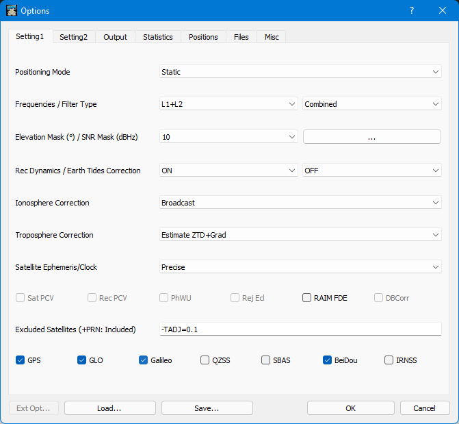
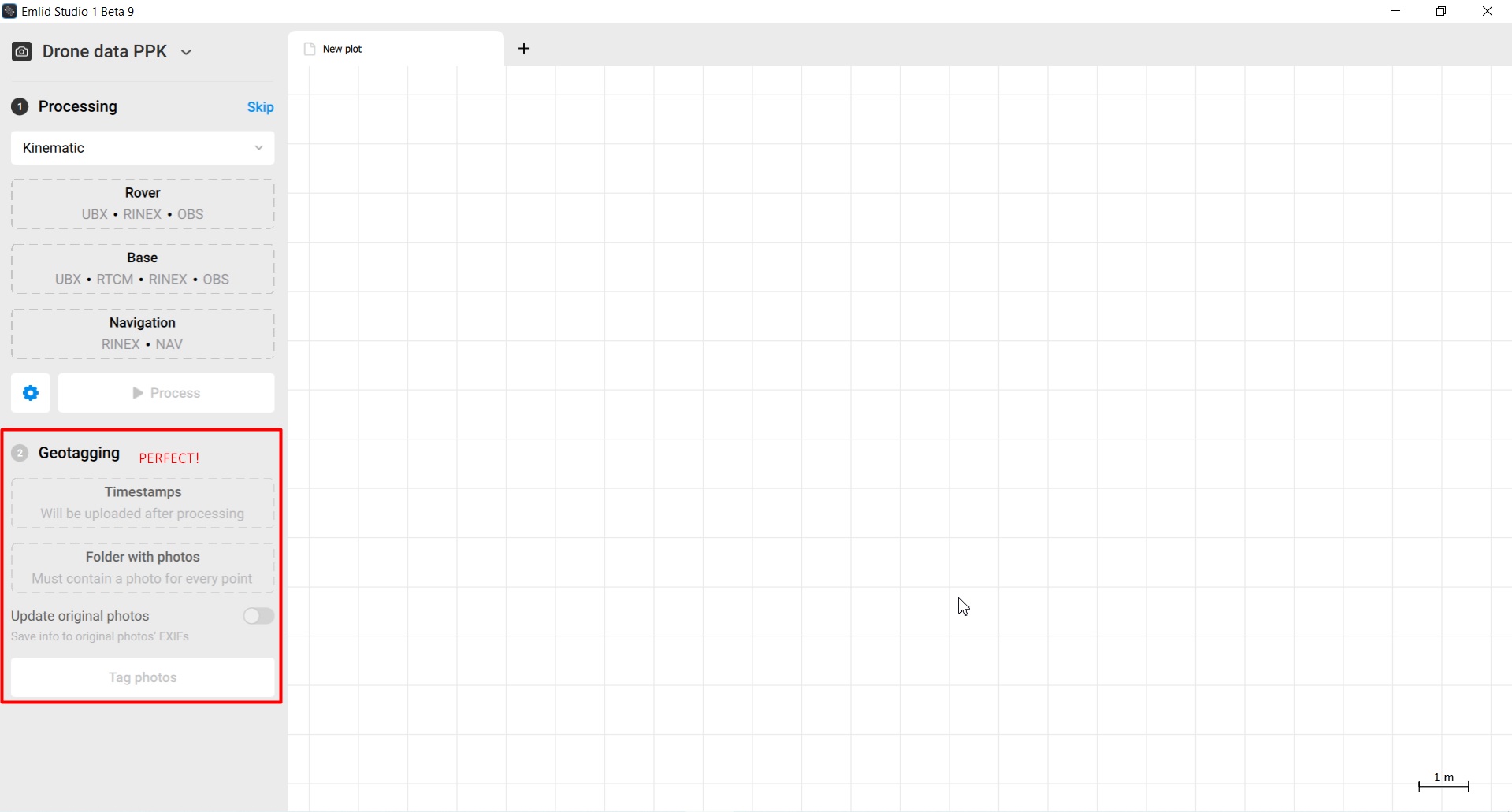
Greetings, congratulations for the new tool implemented in Enlid Studio to geotag the photos taken by drones, this function is very important for mapping work using embedded PPK.
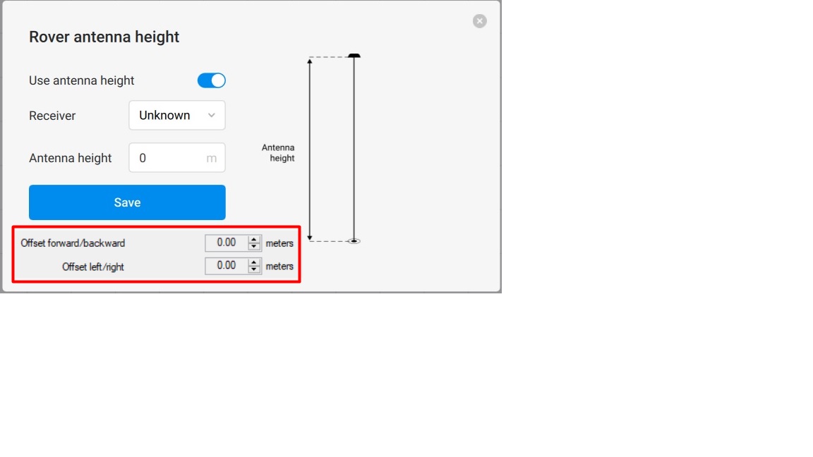
I would like to make a suggestion for a new version of the software, the implementation of rover antenna offsets for more precise adjustments in the geotag, this new function would be of great importance.
The software is perfect!
5 Likes
Hi Fercon,
Thanks for the high praise!  Emlid Studio is the software we very much enjoy using ourselves
I see! These offsets are necessary to include the difference between the antenna’s and camera’s position, correct? As far as I know, this is something that can be handled in the photogrammetry software afterward. It just seems more appropriate to do so as to keep all offsets in one place.
Nevertheless, it’s a good point to discuss with the team! I’ll get on it.
3 Likes
Thanks for answering Polina!
This adjustment of the offset of the antenna to the optical center of the camera is usually performed in the process of geotag the photos in most geotagging software I know, including correction of the antenna inclination based on the angles of the gimbal motors.
It would be of great importance if you could implement this tool in Emlid Studio.
Anyway the Software is very good, congratulations for the development of this very useful and simple working tool, perfect!
1 Like
Hi Fercon,
Got you! Definitely discussing this with the devs. We’d love to make Emlid Studio as useful to you as possible
1 Like
Hi. It woul be great to be able to load more than one rinex file to the base. This is useful when your rover needs more than one base rinex file to post prcess.
1 Like
Hi Jose,
Sure, I can get that it’s useful when your base log is time-separated. We’re taking care of it
1 Like
Hello everyone!
The v1-beta-10 is available for downloading!
macOS: Emlid_Studio_v1-beta-10.dmg
Windows: Emlid_Studio_v1-beta-10_Setup.exe
Here is what is new:
-
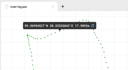
We have made the plot a little bit more interactive. Now you can click on a point and get its coordinate.
-
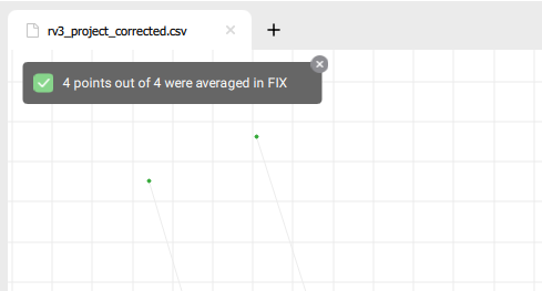
Stop&Go shows feedback at the end of averaging. A popup with a number of successfully averaged points appears.
-
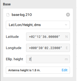
Base coordinates can be entered in DMS format in the base file settings.
-
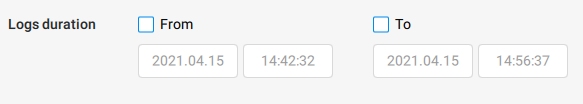
The time ranges of the RINEX file are detected automatically and appear in the Log duration settings text fields.
More improvements are on the way, we will keep you posted!
As usual, check out the full list of changes below.
Added:
- The base latitude and longitude can now be provided in degrees, minutes, and seconds in the base observation file settings.
- The fix-and-hold mode integer ambiguity resolution mode is added for GLONASS.
- Added automatic detection of the time ranges of the RINEX file in the Log duration settings.
- At the end of Stop & Go a notification popup appears providing the number of successfully averaged points out of total.
- When clicking on the plot the current point info is displayed in a tooltip, from where you can easily copy it. For the ground track: when clicking on a solution full LLH coordinates are provided, otherwise only latitude-longitude.
- Log duration settings now allow you to paste date and time from the clipboard.
Changed:
- The application popups look has been unified.
- The resulting files will no longer be overwritten.
- For NMEA solution format in PPK, Emlid Studio uses the .nmea extension. Also added the ability to use .nmea files for plotting, Stop & Go and drone data PPK.
- The list of accepted files is provided in the tooltip on the question mark hover. File type names are unified.
Fixed:
- An incorrect number of time marks/events appearing in RINEX/events.pos when converting from M+/M2 UBX is fixed.
- The file type validation on Windows when selecting or dropping files has reached the level of macOS strictness: no more ZIP files in the NAV file slot.
- High sensitivity of scrollbars on high-precision touchpads is fixed.
13 Likes
Hi,
When collecting points with a rover on the field in FIX mode while the base as been set up in Average Single, all coordinates have to be corrected afterwards according to the PPK results of the base post-processing to get absolute accuracy of the data. The correction is the difference between the averaged single coordinates and the PPK coordinates. So my questions :
How can we get the average single coordinates that were used during the field collection ? Are they those in the RINEX header of the base ?
How to deal with the base antenna height ? Is it to be added to the correction or not ?
Thanks a lot !
1 Like
Hi Florian,
You’ve described the workflow correctly!
To get the coordinate after you have averaged the base, you will need to record it during the survey. Basically, you can copy it to your notes, for example. For now, you can’t save it in the ReachView 3 app. The RINEX header contains the averaged position as well, however, it’s a bit different - it’s averaged through the whole surveying time.
When you average the base’s position in ReachView 3, you don’t include the base’s height there. So you will need to make sure that both base’s and rover’s antenna heights are included during post-processing.
1 Like
Thanks @polina.buriak,
I understand. But I’m afraid this can be a source of big mistakes if RINEX header coords are different thant RTCM transmitted coords. Maybe adding a copy button in the Base mode window would help saving them on the mobile device ?
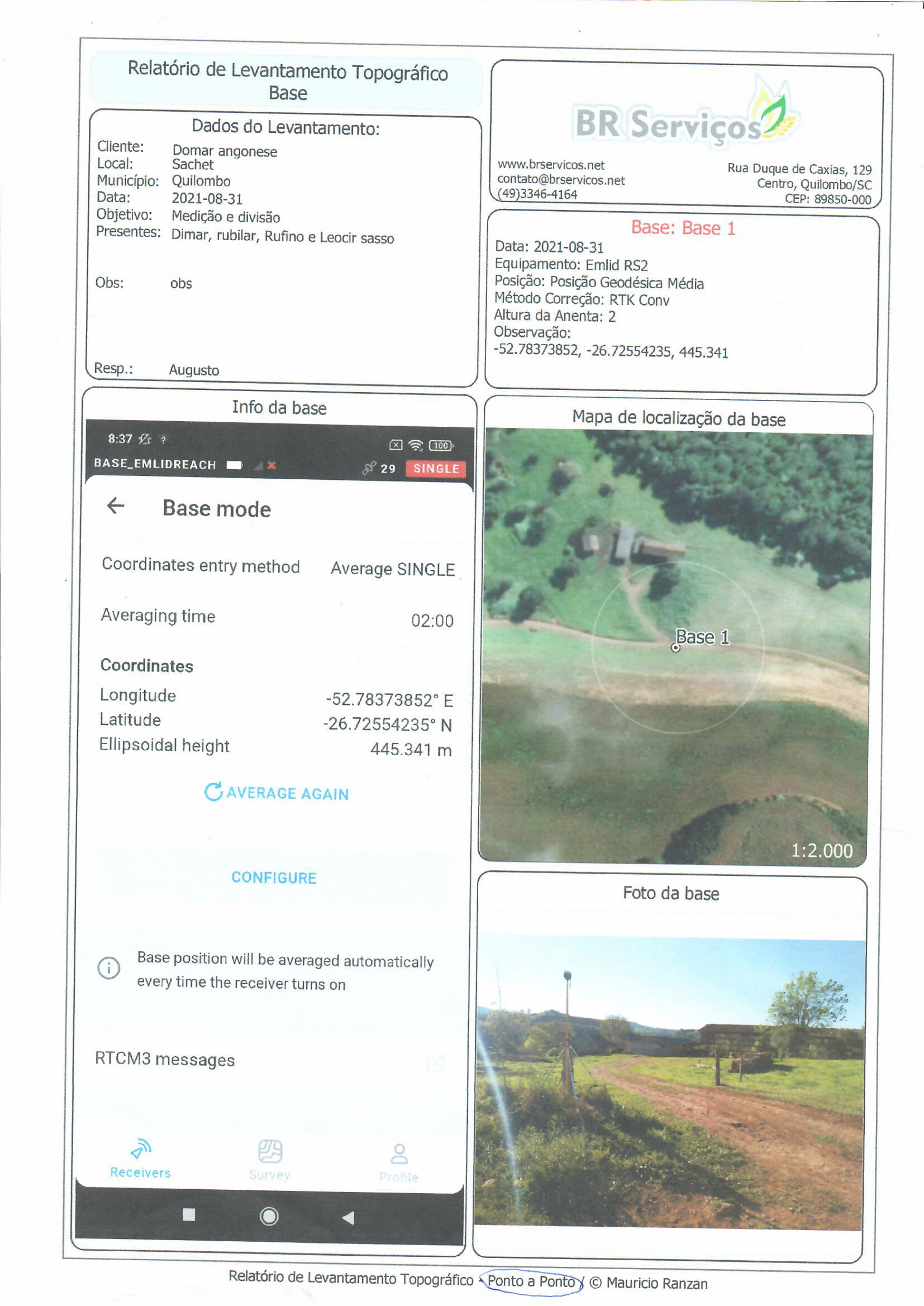
Hello,
To note the position used in the base I created a form in QField where we have information about the work such as:
Client:
Local:
County:
Survey date:
Purpose of service:
People present during the service:
Responsible for the work:
Base Information:
Equipment:
Position used:
Correction method:
Antenna height:
With that, I generate a base report, including all the necessary information.
And also the screenshot of the Base Mode configuration screen.
Plus, a photo of the base and a map of the base location.
5 Likes
I love seeing QGIS being used like this. Building custom data-defined forms and page layouts is very powerful.
1 Like
Florian,
Sure, you have a point! Still, you can copy the coordinates onto your device without any issues. That’s what you can do right now.
Hi Mauricio,
Thanks for sharing the workflow! Very useful indeed if you work with 3rd-party surveying apps in the field
Hello @polina.buriak
I use Reach View for surveys.
Sometimes I use FieldGenius because it has location tools, alignments, intersections…
And I use QField only as field notes.
4 Likes
@polina.buriak actually I noticed the base coordinates are in the export CSV file, in the last columns. It seems to be the same values than those displayed in the base mode view.
Hi Florian,
That’s correct These are the values also recorded in the CSV export.
1 Like