Hi Polina,
I have two devices, but at this stage I am attempting to use PPK RINEX files from Ordnance Survey (fixed station) to correct the data from my Reach Rover.
I will email the files to you.
Many thanks
Ian
Hi Polina,
I have two devices, but at this stage I am attempting to use PPK RINEX files from Ordnance Survey (fixed station) to correct the data from my Reach Rover.
I will email the files to you.
Many thanks
Ian
Ian,
Got your data, thanks!
Hello everyone.
Yap I have the same problem emlid Studio does not out put corrected CSV data.
Tried it with other project that generated correted CSV data before. Now it did not generate CSV data.
I’m using v.10 of emlid Studio.
Maybe it’s related to latest update of v.28
Thanks
Hi Polina
No Emlid Stodio need not convert.
What I mean is to populate the easting and northing column of the emlied studio generated CSV so that we can easily copy the points to Auto CAD
THANKS
total noob here trying to upload corrected coordinates to Pix4D and the corrected .csv file doesn’t have Easting Northing, just Lat long. is there a setting I am missing or a way to easily convert? the raw file off the unit has this but once corrected through studio its gone.
Hi Ian,
I’m back with the results!
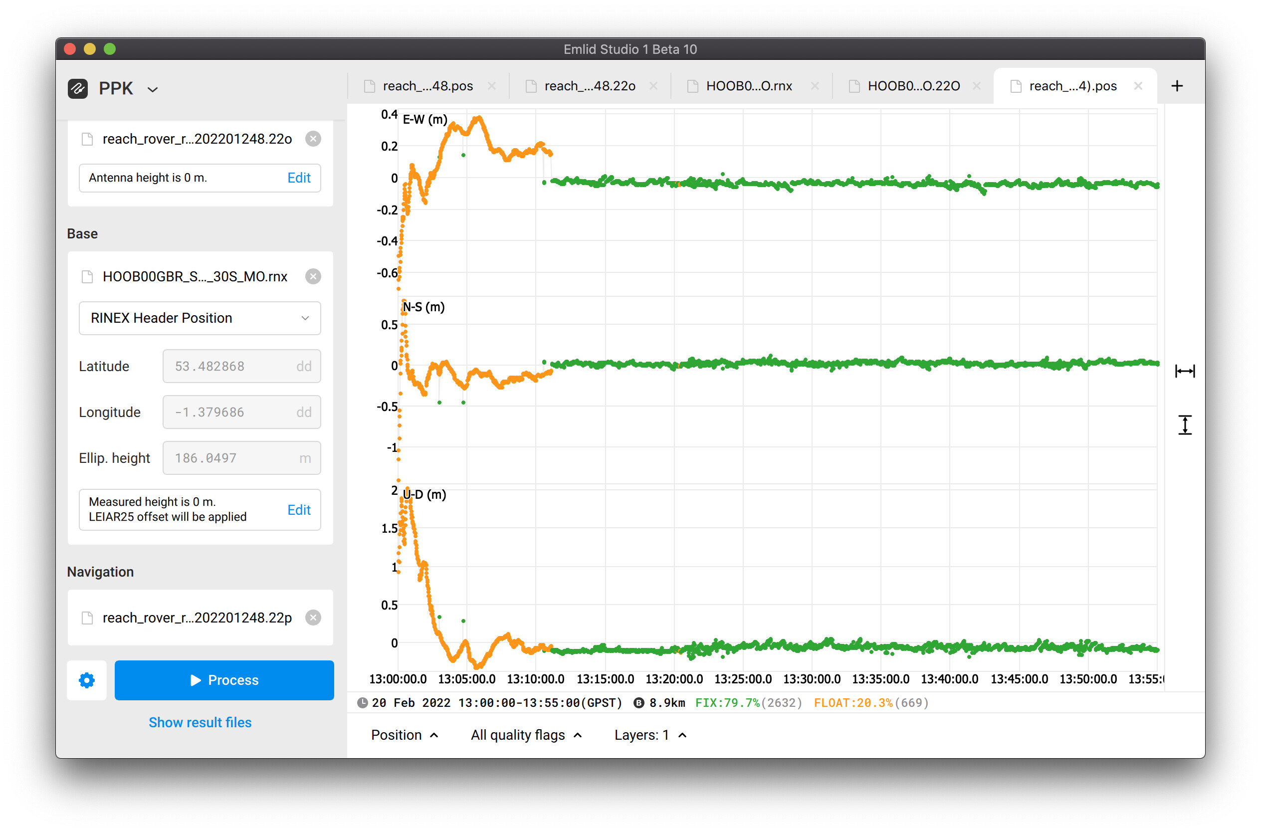
I post-processed the data from your Reach and the UK Ordnance Survey without any issues in Emlid Studio. I’ve used Reach’s logs as the rover logs and the data form the service as base logs.
I’ve used standard settings. It’s hard to get a more Fix percentage because of the quality of the rover’s data. You can check it below:
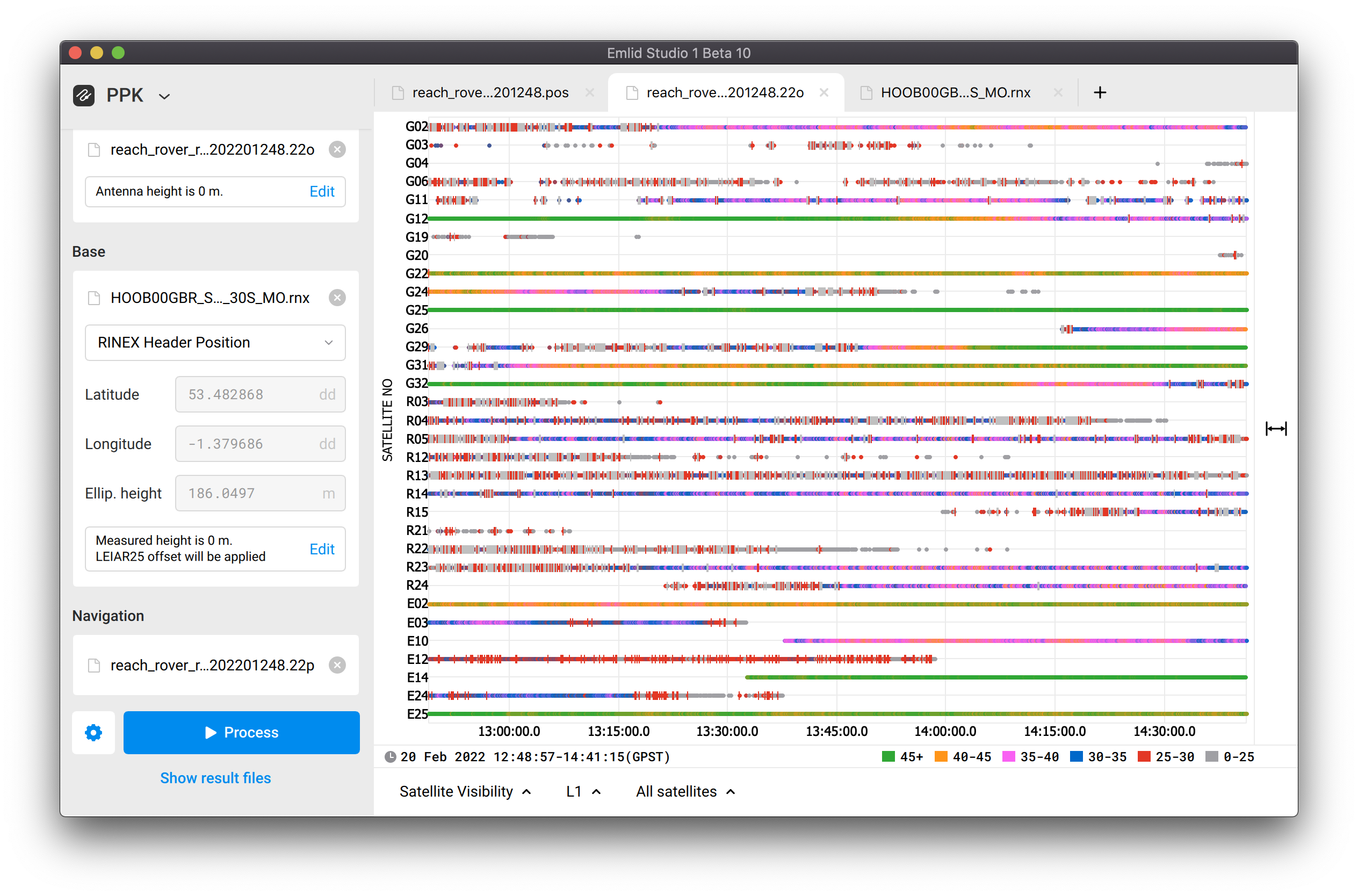
You can see that the satellites’ signals suffer drastically from the cycle slips and low SNR. Most usually, it’s a result of improper environmental conditions or the unit’s placement. So I suggest checking it out in the first place.
Regarding the navigation file, your base’s file from UK Ordnance Survey indeed contains the observational data only, there are no navigational data. It’s a rather common practice. You can use the navigational data from Reach to post-process the files. In case you require the navigational data from the service, I believe you can contact them directly on whether they are able to provide such files to you.
Be sure to ask any remaining questions 
Hi Mon,
This is not an okay behavior of Emlid Studio. Does it happen repeatedly? Do all of your datasets suffer from it? Please share them with us via support@emlid.com so that we can take a closer look. It’d be nice to get the Emlid Studio logs as well if you get an error at the end.
@joel @rbbarral I’ll give a bit more context for the CSV file of Emlid Studio. If you’re working with the file originating from ReachView 3, you indeed have the Easting/Northing columns there. They contain the projected coordinates.
Emlid Studio calculates the geographical coordinates only. That’s why these Easting/Northing columns are empty. Adding the functionality to convert the data inside the Emlid Studio is not in the nearest plans of ours.
As I get it, you don’t need the projected coordinates specifically for Pix4D. If these columns are distracting your software, you can just manually delete them from the CSV file.
Hi Polina
Thanks for the reply. Unfortunately, I’m not yet into using Pix4D. I need the the northing and easting values, for ease in plotting the points in autocad civil 3D especially for road projects and perimeter survey of properties.
Also, as of these writing I am still unable to output CSV data from Emlid Studio and I’m on middle of a large gov’t project.
Just hope you could help me.
Thanks
In pix4d you can choose the coordinate system. enter in geographic coordinates and then transform to plane coordinates
Thanks.
I guess I have to learn Pix4D.
I don’t have any idea about it.
Thanx again…
He does not use Pix4D. You are mixing up more than one user/issue.
As a work around, you might see if you can make the conversion using QGIS, or perhaps an online transformation tool.
Thanks guys really appreciate your help.
I reverted to version 9, still does not output corrected CSV. Upgraded to version 10, same thing it does not output corrected CSV FILE.
I wish someone could help me solve this problem cuz I’m on a middle of a government project.
I really like Emlid Studio, gives accurate fixed GCPs.
Problem started when I updated to latest firmware version 28.2.
Really need help.
Thanks everyone,
Mon
Same in Metashape, very useful feature!
You can get easting and northing values in the coordinate system of your choice in a matter of a few minutes if you import the corrected CSV from Emlid Studio in QGIS.
I don’t know your level of comfort with QGIS, but if you save your imported CSV to a format like DXF and use your target CRS for the output, the geometric coordinate values will be changed accordingly.
You can also keep everything in a text file if you want. If you import the CSV and go to the attributes table, you can use the field calculator with these expressions to add and populate Easting and Northing fields:
x(transform($geometry,'EPSG'****','EPSG:****'))y(transform($geometry,'EPSG'****','EPSG:****'))Just replace the asterisks by the code of your source and target CRS. Then you can save the layer as a new CSV and the fields will be there.
Hi everyone,
Thanks for sharing your experience with the transformations!
@rbbarral Let’s understand what happens with your processing. For that, I need to see your data. Without it, it’s hard to say anything for sure as we’ve never faced it with our own data. So you can share the data with me via support@emlid.com so that we can start an investigation.
Hi everyone,
Thanks for your time in sharing to help me solve my problem.
I finally solve the cause of such behavior and it was all my fault (sorry)…
I did not input the CSV obtained from the fieldwork.
However, I’d like to ask if it’s okay to use fixed points from the corrected CSV with very high (double figure) PDOP.
THANKS Again guys.
Hi @rbbarral,
So, that’s a good start! You can now work with the CSV from the Emlid Studio.
It’s a difficult question you ask. We usually recommend checking out that the DOP values are low. These values are connected to the satellite geometry, and it can affect the quality of the data you’re getting. Still, to make conclusions about the overall data quality, it’s important to monitor other factors as well.
I’ll just keep asking you to share the data with us if you have any doubts ![]() It’s the easiest way for us to recommend anything for you. If the data is sensitive, please, share it with us at support@emlid.com.
It’s the easiest way for us to recommend anything for you. If the data is sensitive, please, share it with us at support@emlid.com.
I’m just curious if Emlid Studio uses either RTKLib and / or GeoSetter code ?
The ppk solutions that I’m aware of all use RTKLib under-the-hood and so I wonder if ES does as well (which is fine) or if it’s all original code?
Thanks!
A post was split to a new topic: No LLH in corrected CSV