Hello,
Tell me, what are the accuracies to be expected when using the EMLID NTRIP Caster correction system?
Regards,
Arnaud
Hello,
Tell me, what are the accuracies to be expected when using the EMLID NTRIP Caster correction system?
Regards,
Arnaud
Welcome, @arnaud.konan, to the Emlid Community forum!
Expected precision is the same as rated equipment precision for RTK placements. According to the RS2 data sheet, real-time kinematic positioning (RTK) has the following accuracy:
Horizontal: 7mm + 1mm every km away from the base; and
Vertical: 14mm + 1mm every km away from the base.
Source: RS2 specs on Emlid site. Link here.
PS: GNSS receivers work with expected precision. For accuracy, it is necessary to analyze the conditions of the environment in which the survey is being carried out, in addition to the positioning method used.
Welcome to the forums!
Just making sure it’s clear: Emlid’s caster isn’t a correction service. It’s only an NTRIP server. You still need two receivers to transmit and receive corrections through the server and, accordingly, precision/accuracy will be dependent on those receivers’ specs/abilities (as listed above by Pedro) and the quality of your base setup.
Thanks @Gabriel_C , I forgot to tell Arnaud about this Caster function. 

Hi Arnaud,
All the main points are already listed, so I can just confirm that the Emlid NTRIP Caster works the way Pedro Augusto and Gabriel described ![]()
I’d also recommend our NTRIP Caster vs. NTRIP Service article, as it shows the difference between the casters and services in more detail.
Thanks Pedro and Gabriel !
So when do we need this NTRIP Caster ?
Because with two receivers, I can simply set up my base on a point known in nearby coordinates and broadcast the correction to the rover via the LoRa radio protocol.
@arnaud.konan Considering LoRa has a relatively short range and requires mostly line-of-sight to maintain a constant connection, we have found that when we have access to cellular data, using the caster is much more stable and we don’t have to worry about range anymore.
This constraint’s absence enables us to choose the best location for our base without any compromise for radio range.
Super Gabriel !!
I just read the article @ kseniia.suzdaltseva left me and I even came to ask this question you just answered me.
So, by using the NTRIP Caster the range of the signal becomes greater.
Hello @kseniia.suzdaltseva
Thank you for this article. It been clear for me.
Gave we the maximum range attainable using the caster ?
Hi Arnaud,
Since the corrections are transmitted via the Internet, there’s no distance limit for the Emlid NTRIP Caster itself. You just need to consider the receiver’s max supported baseline:
10 km in RTK for Reach M+ and Reach RS+
60 km in RTK for Reach M2 and Reach RS2
2 posts were split to a new topic: Correction link for aerial mapping
So I have been running an nTrip base station on our shop since May. RS2 plugged into USB and connects to our office via Wifi.
I use it out to roughly 50km. Though most sites are 15-30km away.
I did extensive testing on a site 15km away. The highest error I am seeing on Alberta Survey Control Markers (ASCM) is 12.5mm vertical, and 11mm horizontal. This is my most recent testing that shot the same spot over 5 different days.
My setup was to allow the Base to set as a single point for 30 minutes. Then I shot the nearest 3 ASCM’s to the shop. Then adjusted the coordinates of the base station to tie into that typing them in manually.
So whenever I start a project, I still need to localize (THANK YOU FOR ADDING THAT FEATURE), as no job is ever perfectly tied into ASCM’s, but after that, I can just check in and check out everyday.
Given that it is a long-term test so far, I’m very happy with the results.
The biggest thing I noticed, is that once we hit late fall and winter, I was getting poor RMS errors. I ended up reducing my SNR mask from 35 to 30, and horizon from 15 to 10 degrees so I could use more satellite data. I guess I’m far enough up north that the satellites aren’t as visible in the winter as they are in the summer.
According to these papers SNR30, and 12deg mask are optimum. You have basically proven it again, the science is repeatable!
2013_ION GNSS_Liang_optimum mask 12degrees .pdf (754.0 KB)
optimumsignal db 30 or better.pdf (1.6 MB)
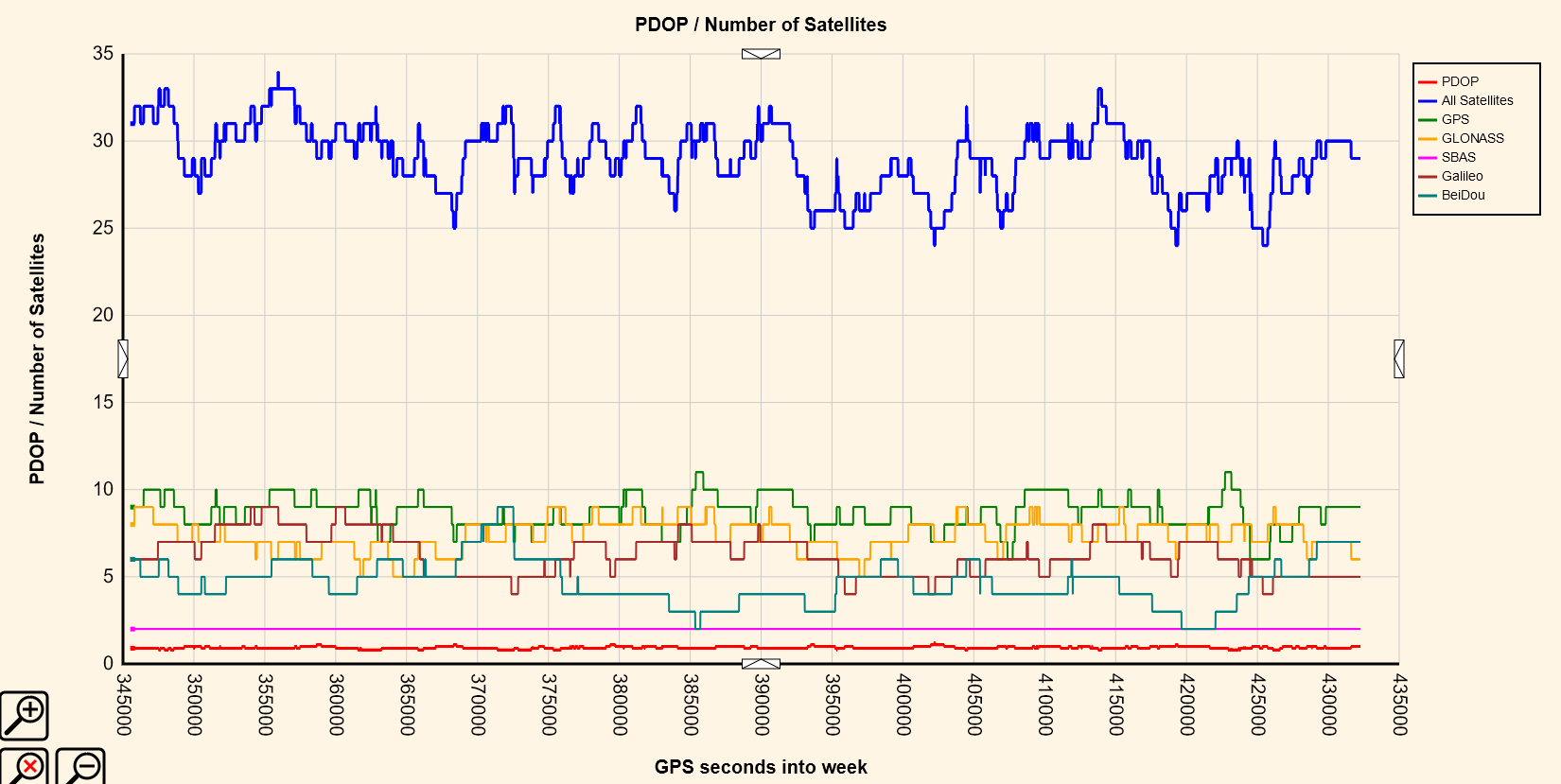
I am also in Alberta here is a long term SIV chart from my base, and it looks like the average number is dropping off pretty cool! learned something today!
The long term trend is down, good thing we do not farm in winter!
Very interesting. What duration/iteration did you use over each ASCM?
I did 2 minutes over each of them. Though TBH, the exact position of the base station is pretty irrelevant. Except for the one job that is tied into the same ASCM’s, (14km away), I have to localize at the start of every job. So as long as it’s the same all day everyday, it just works.
Hi Grant,
Nice to read about your workflow! It’s cool that our new feature came in handy 
This topic was automatically closed 100 days after the last reply. New replies are no longer allowed.