


Hello all. Im using FieldGenius’s program to stakeout lines and points on a lot of our projects . So when I start I collect a point from my site and start drawing points and lines from there . What i did notice is when I go 90 degrees from from my point it doest look 90 . Can it be possible for when you start to move done a line that it could actually not be ninty degrees?! In the attached screan shot the roads here are supposed to be 90 and 180 degrees.
notice the line where to rover is now.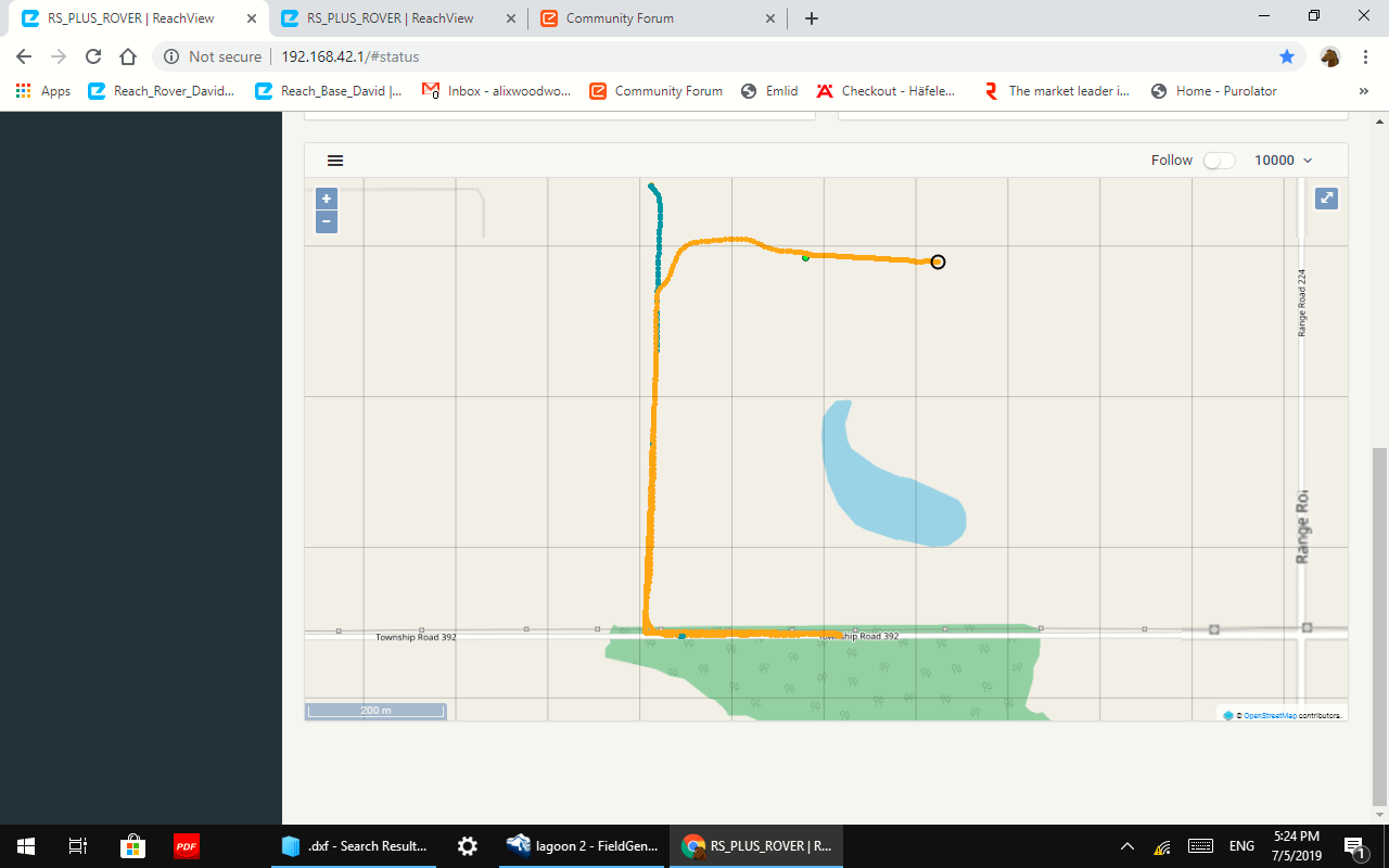
1 Like
Projection distortion? Road are “supposed” to be 90, 180 deg… they may necessarily not be exact.
Float? (orange) not Fix (green)? But that shouldn’t have anything to do with a 90 deg rotation?
Even when I stake out in fixed mode.
1 Like
It may the difference in the projections of ReachView ( EPSG:4326) and your coordinate system in FieldGenius?
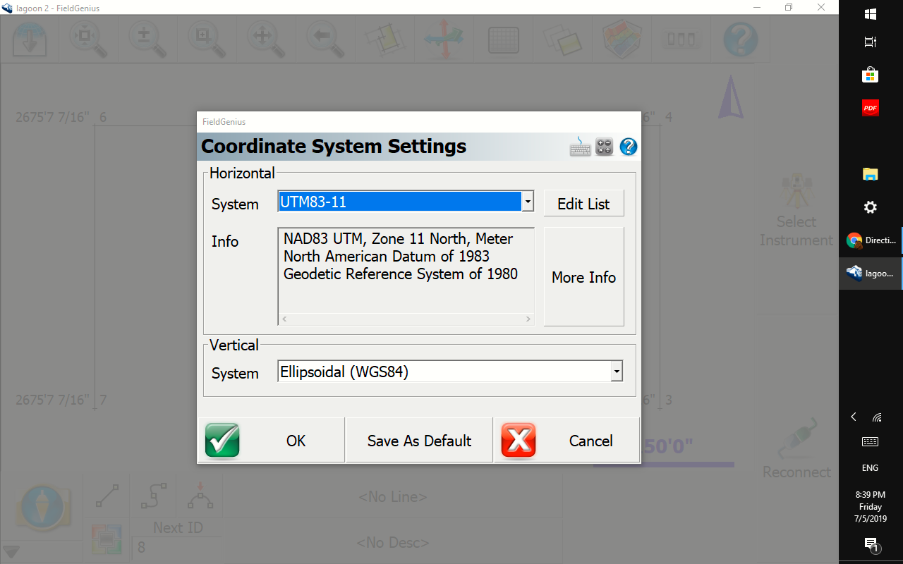
What is your horizontal coordinate system in FG?
1 Like
Good question.
That’s the only option there is.
You need to make sure your using the CORRECT UTM NAD83 coordinate system for the region you are in. I think UTM83-11 is the DEFAULT coordinate system in FG where MicroSurvey is based in British Columbia. Are you located there also, then fine, if not you can “Edit List” button and ADD your coordinate system to choose from and also remove what you do not need to avoid confusion, error messages etc.
Your vertical system is WGS84 which is the same as what ReachView uses… but ReachView also uses WGS84 EPSG:4326 for the horizontal. NAD83 is almost the same as WGS84, but not exactly but good enough to use between the two. You can different coord systems, but need to use what is standard for your area and work.
2 Likes
Use “Edit List” button and get a slew of coordinate systems to choose from. This is something ReachView really needs implemented now that RS2 released.
2 Likes
Thanks a lot .Ididnt know that
1 Like
Also you can download GEOID file(s) to use for your vertical system instead of WGS84. Then you can get ortho height (in FG) in addition to ellipsoid height (reachview).
You can find the GEOID files link at MicroSurvey support.
https://helpdesk.microsurvey.com/index.php?/Knowledgebase/Article/View/479/46/world-geoid-models-download
1 Like

1 Like
Just for a mental picture of the amount of convergence in the north/south direction:
If you and a friend were standing at a spot on the equator. Your friend walked 10 meters east, then you both walked towards the pole for 100km. At the end of your walk, you would be 1mm closer together than when you started.
Say that you and your friend traveled to the 45th parallel (half way between the equator and the pole) and did the same exercise. At the end of your 100km walk toward the pole, you would be 158mm closer together.
Say that you and your friend then traveled to the 89th parallel (almost at the pole) and did the same excercise again. At the end of your 100km walk toward the pole, you would be 805mm closer together.
So yeah, that was a lot of walking, but it proves that the apparent error in the map has got to be in projection or calculation. Because at the distance scale of a few hundred meters in the map above, the convergence will be measured in µm.
3 Likes
Yeah, but looks like that horizontal leg is only about 400m? The vertical direction of the grid is elongated also, which i assume due to projection.
I don’t think he is using the correct UTM (NAD83) coordinate zone for his region also in FieldGenius project setup. His vertical is ok though using WGS84 like ReachView.
I think he is using the default zone 11 North in FG for British Columbia, but he may be located in UTM83 12U North? (Alix, CA)
2 Likes
I guess if FieldGenius lets you be on the wrong grid and way outside the extents of your local grid, then there could be something funky going on with distortion and angles. 
Yeah, probably so. It will pop a warning up up though about it. I.e. you chose a UTM coord system say in Antarctica, but your in Ecuador with your Emlid GNSS! It knows that and pops a warning up. You can still work in it, but it’s the incorrect UTM83 ZONE (NAD83) altogether.
FG requires you to choose a coordinate system at start of project. I think you can change it though later? Either way, I noticed Topcon Field Magnet doesnt require a coord system to be set? So not sure how that works… maybe it just uses WGS84 like ReachView?
2 Likes
If that is the case, then @davehofer1993 should be able to confirm that he saw some warning, and then switch to the correct grid and try again.
2 Likes
Never got no warning about that . If I get that setting to U12 it takes me north of 90 degress and U11 takes me south of 90 degrees , In both ways about 8 feet in 300 feet 
you may be in an overlapping area?
What is an exact coordinate example of the area you are working in? You need to know what UTM zone to set it at in FG.
If your GNSS is outside of the working coordinate system chosen substantially it will warn you. You may be in an area I guess within tolerance?
Seems to me from your screenshot, you should be using UTM83 12U North?
If you find you have collected points in the wrong coordinate system/zone later, this may help:
https://helpdesk.microsurvey.com/index.php?/Knowledgebase/Article/View/1480/153/