


no I don’t have the access, I juste have this :
https://drive.google.com/file/d/1zgc2OpHxxZQgxcfCUPff0CdBWMsUnKvm/view?usp=sharing
no I don’t have the access, I juste have this :
https://drive.google.com/file/d/1zgc2OpHxxZQgxcfCUPff0CdBWMsUnKvm/view?usp=sharing
If you have setup the receiver more or less as default, you might have been logging the corrections as well ?
The logging of this is enabled by default.
Currently, using a Euref station, the closest Base station is 100 km away, which a little too much for comfort.
yes in fact i have them in RTCM3 :
https://drive.google.com/file/d/1lbC4wV52NhqPIJxJDnyQvMgCSJsaoo5Z/view?usp=sharing
I’m not using Euref, I’m using Orpheon, the closest base is around 30 km
Trying to process it now.
I see you have a lot of periods where you have extremely poor SNR. It is always a good idea to keep a good signal for the receiver throughout the whole survey. That way you will get a more consistent survey, especially in case you have to post-process.
I get 60.1887 m, using the Rines header coordinates of your correction log. Does the station have an official position ?
Wouldn’t that contribute to the problem? From what I understand, RS+ vertical (Z) is about half as accurate as horizontal (XY)?
I’d reiterate if the “ROVER POLE” definitly “FIXED” style and not an “ADJUSTABLE” style to avoid accidental inconsistent “POLE HEIGHT” therefore accidental “ANTENNA HEIGHT” just to rule this out systematically?
Same for the TOTAL “ANTENNA HEIGHT” so to make sure that was properly accounted for between visits?
Photo of rover pole, with adapter etc?
Maybe the 30km baseline is just too much isn’t it to the base? Better to just use another RS/RS+ (or get 2 RS2! If you have the $) as BASE.
Depending on the cost for the CORS service, may justify purchasing another Emlid Reach to use as a base.
Wouldn’t this contribute to false fix? Even more so with vertical?
Agree on that. 3x times the recommended distance of max 10 km.
It might, yes, will try to process using Continous instead.
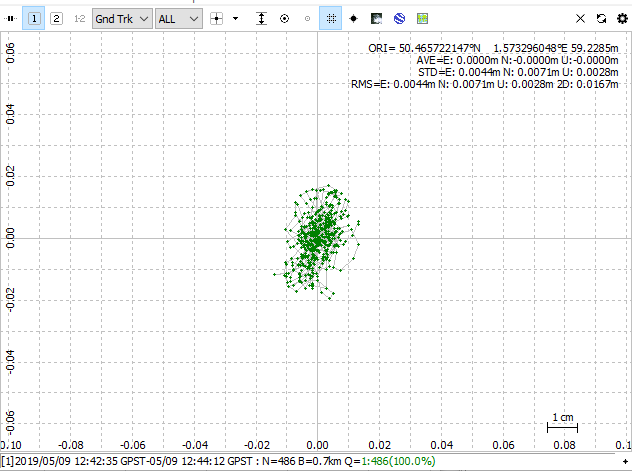
Well, that actually did the trick. Elevation 59.2285 meters, 3D rms 0.0167 m.
Guess it is down to the combination of long baseline and bad SNR at certain points.
So how can I be sure during the survey ? Which parameters should I have to check because the “fix” solution seems to be not sufficient?
Everything was checked, We are using this method since years with Leica Devices, no problems until we are using the “ntrip” correction and Emlid RS+
According them, it is sufficient http://reseau-orpheon.fr/le-reseau-orpheon
Not yet, I will tonight.
Interesting, how did you reprocess the data ?
I will try next week
That is with L1/L2 multifrequency, like the Emlid RS2, but RS+ being single frequency, max recommended baseline is 30 km.
As you can see, it does work, but the fix requires very good SNR to rely on the data at more than 10 km.
Ok, so during the survey where on the app ReachView can I check the good SNR ?
Big thanks for your help !
The green bars!
https://docs.emlid.com/reachrs/common/reachview/status/
Personally, depending on finances, if low $, get another RS+ use as base with LoRa (LongRange).
If finances $$, get a RS2, use as ROVER (base RS+) until finances $$$, then get another RS2. Not sure you’ll get full capabilty RS+/RS2 combo, but hopefully better results using RS2 as rover under trees, bad conditions etc.
If finances are $$$, get 2 RS2 receivers.
Yep, in the Reachview Status panels.
On the signal to noise ratio ? Never seen green bars here, only blue ones… 0_0