


Can you please clarify that the diagonal measures with RS2 can be done or not ,
Hi Raouf,
What do you mean by diagonal measurements? Can you please describe the process in more detail?
1 Like
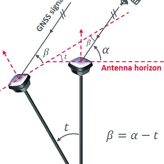
i mean how i can get building corner measured while there is a balcony for example , can i tilt the rover to catch a satellite sign or not.
1 Like
We don’t have such a feature in our receivers yet.
1 Like
thanks for the answering …
More info. A very desired feature. I know there are drawbacks in accuracy, but either way, would be nice feature to implement and at least have the choice to use it or not depending on need. Seems a no brainer due to the nature of GNNS when adjacent to building walls. That extra little bit may help capture that point. Beats the hell out of recording manual offsets.
Also search tilt compensation.
Seems this would be a new GREAT feature on a new version of the RS2? I.e. RS2+
; )
3 Likes
Why not use building offsets ? We’ve been doing this for years with GNSS and terrestrial traverse and is remarkably accurate if you have a good eye.
Personally, I use a “Robert” (plumb bob) and align by eye with the building line with a 20’ offset or whatever distance you need for the offset. I usually set a nail at the offsets. Do the same at 90° perpendicular to the last offset on the other building line. Locate both points via GNSS or traverse and also measure the offsets by tape measure to the building corners as verification. I’d be careful using GNSS around buildings and vegetation. I’ve caught many a bad measurements from other Surveyors; they don’t verify what they’re locating.
With care, you can achieve an accuracy of less than 0.1’ (3 cm). We do this all the time when we can’t locate a building corner by traverse or reflectorless measurements.
You can learn a lot from old Land Surveyors like me
7 Likes
Second this ![]() .
.
Here is an example from one project. Extend fasade lines and create intersection points. Par it with a drawing you can tell if a point bad or not.
https://twitter.com/ToreCrash/status/1319318016472002565/photo/1
6 Likes
Exactly ! ![]()
I’ve have similarly used the above methods by Bryan & TB, but usually adding a bi-pod to the mix depending on accuracy needed. Doesn’t take that long to do. I agree that the tilt measurement feature would be handy in some situations though. Just don’t think we will get there with an Emlid receiver because of cost and software development needed. I mean those tilt compensated receivers from the competition (Trimble-Lecia) are not cheap, min. of 18-32k. And how would Emlid cancel all of the the multi-path signals coming off that close to the building?
2 Likes
Not sure with such a great Emlid product and software, why it’s “impossible” to implement this since the hardware is there? This feature really is something desired by the majority… and even if not used for just building corners.
The receivers in this link are much cheaper than Trimble/Leica:
Hi there,
What cool land surveyors’ tips are in this thread! Guys, thank you for sharing them ![]()
From my side, can say that we keep in mind the idea of tilt compensation support. Now we’re investigating how our devices can utilize it. But as it’s quite a complex feature, this research will take some time.
And I also second the thought that you need to be careful using GNSS receivers near buildings. Multipath results in error in pseudo-range measurements, which affects positioning accuracy. Besides, buildings and any other obstacles block the sky view. That’s why they are far from perfect conditions for the receivers.
7 Likes
Why NOT?

+1 here for option to enable tilt compensation. I survey using RS2 attached to a backpack so having tilt compensation would help to correct for errors.
Hi Chris,
Welcome to the community forum!
Got you, thanks for your request. I’ll note it.
This topic was automatically closed 100 days after the last reply. New replies are no longer allowed.