


I’ve been reading up on CORS base stations and their locations in their logs. It gives locations with an approximate location (within 1 Meter) therefore, how do we know the ‘exact’ position of a reference station if the location given in the logs and RTCM headers is approximate ?
Dave.
Metadata / Station Logs
Station/site log files contain all the historical equipment (receiver/antenna) used at that site, approximate location, owner and operating agency, etc. We stress that the the position/coordinates listed in the log file like that in the RINEX header files should be considered APPROXIMATE. When a user downloads data they should at the same time download the published NGS coordinate (position and velocity) file for that site.You can find that file here.
Thanks Tore, Where do I get the same information for European stations ?
You knew I was going ask  - How do easily convert Cartesian XYZ to lat long (WGS84) ?
Two options that comes to mind.
Online for single and batch - NGS Coordinate Conversion and Transformation Tool (NCAT)
And free application - Qgis
Oh, and this one https://epsg.io/
1 Like
What datum is the EUREF coordinates in?, I’ve tried WGS84 and ETRS89 in NCAT and don’t come anywhere near the station (>10meters). What do I put into ‘Radius in meters (a)’ and ‘Inverse of Flattening (1/f)’ other than what I tried. Thanks for epsg.io that appears to only have XY rather than XYZ
I guess that depends on your country or project.
We use mainly Euref89 UTM or NTM.
For the Z value i dont use world geoid system, we have local hREF NN2000 or older systems
Do you have an example of a position to be converted?
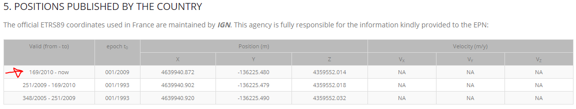
Yes, It’s the same as before, I’m ‘playing’ with two reference stations one in Spain and the Other France referencing one against the other. The stations are SCOA as base and PASA as rover and the location info you kindly supplied from here being the rover. What I’me doing is placing a waypoint(LAT-LONG) in RTKPLOT to see how far off the corrections are. What I have so for XYZ 4639940.872 -136,225.480 4,359,552.014 is 43.3952318765,-1.6816816942 which is very close. I previously used one of the other supplied coordinates which was further off.
For reference I’m the UK (England not Ukraine ![]() )
)
And XYZ 4639940.872 -136,225.480 4,359,552.014 beeing ECEF coordinates, right?
Ah ok, its from a euref station, thought it was from your reciver.
ETRF should not be meters off from WGS84 when converted, so something is not made right.
But this part here, how do you process this? those stations are far away from each other
I should have explained better, The idea being the two stations are 21.8 Km apart therefore, I’m seeing the size of error with that baseline distance. I’m using RTKNAVI with two inputs with a FIX then into RTKPLOT.
Why not use RTKpost ?
I have done, but easier to use RTKPLOT ‘live’ to see how changes in options have an effect.
Not bad for L1 only with a 21.8363 Km baseline - SCOA? is the converted location and the other waypoints are after a few seconds following a FIX
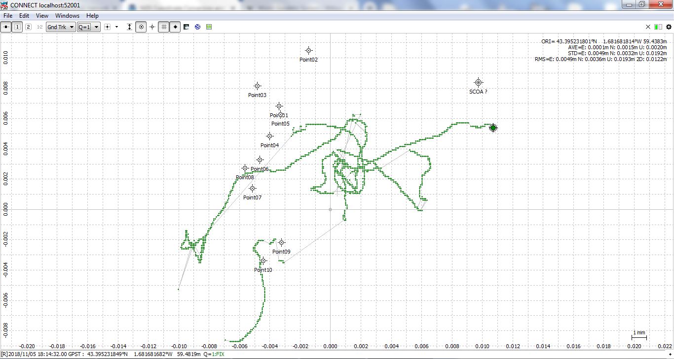
Using the combined filter in RTKPOST should get this to be an even tighter group. At 21 km, it should tighter
So its solved then?