The other 2 CORS are within the recommended baseline, GUUP and WAPA.
It’s also worth checking these two, as their sampling rate is 1 second, which is way better than the GUAM base.
The other 2 CORS are within the recommended baseline, GUUP and WAPA.
It’s also worth checking these two, as their sampling rate is 1 second, which is way better than the GUAM base.
So you recommend to record at higher rate, ie 5 Hz and use GUUP and WAPA as bases?
I’d recommend recording at a higher rate, at least 5 Hz. As @jbonde002, recording at a higher rate in this environment might result in noisier data. However, you can always use Emlid Studio’s Convert to RINEX option to decimate your data into a smaller sampling rate.
For the base, it might be worth trying all three and comparing the results afterward.
What’s the goal of the survey? That is what will determine whether or not GNSS is the right tool for this environment.
Thank you!
I always save recordings in Rinex. Is there a tutorial you would particularly recommend that explains how to decimate data from 5 to 1 Hz in Emlid Studio ?
Going out surveying tomorrow morning.
This guide doesn’t show how to decimate the logs, but explains how to use the Convert to RINEX option.
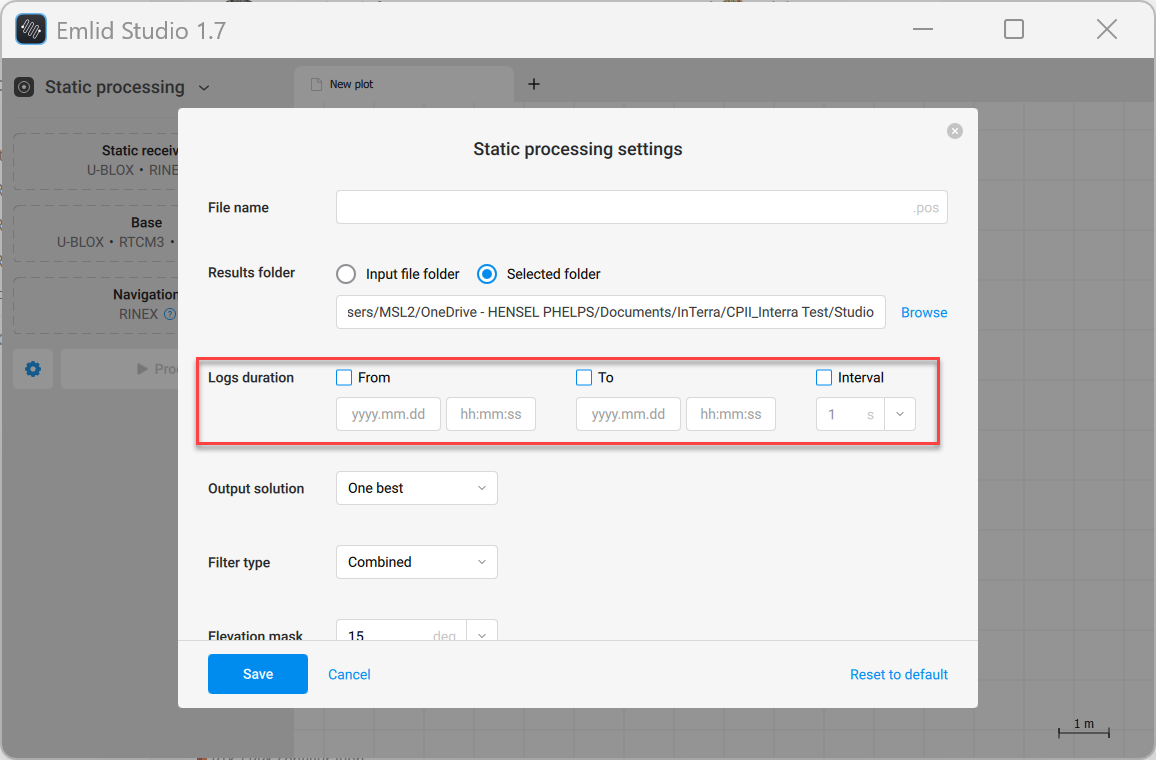
You need to change the interval there.
PS.
I forgot that there’s also an option within the Static and Kinetic settings. Thanks @michaelL, for pointing that out!
So if I log in 5 Hz mode and then I set the interval to 1 s (as shown on the screenshot @michaelL provided), that would do the 5 to 1 Hz decimation?
I also assume that the base averaging time to be maxed to 29 min would be best?
Yes, you are right.
I also assume that the base averaging time to be maxed to 29 min would be best?
Could you elaborate on this further? Since you’ll only log the raw data, you do not need to average the receivers. Once you turn the receivers on, there’s no need to wait or average them.
OK. That was my question, what role does the averaging have. Seems like the default setting is 6 sec.
I still averaged this morning as I didn’t read your message in time. I guess that averaging goes in a separate file and that rhe RINEX raw data file remains unaffected?
Averaging doesn’t affect the raw data logs, so you can start raw data logging without averaging the base. Averaging is only needed if you’re using the receiver as a base for RTK.
Thank you for the explanation.
Managed to process the date of a point that was logged for almost 7h.
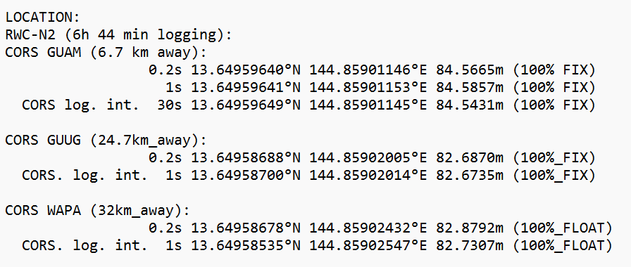
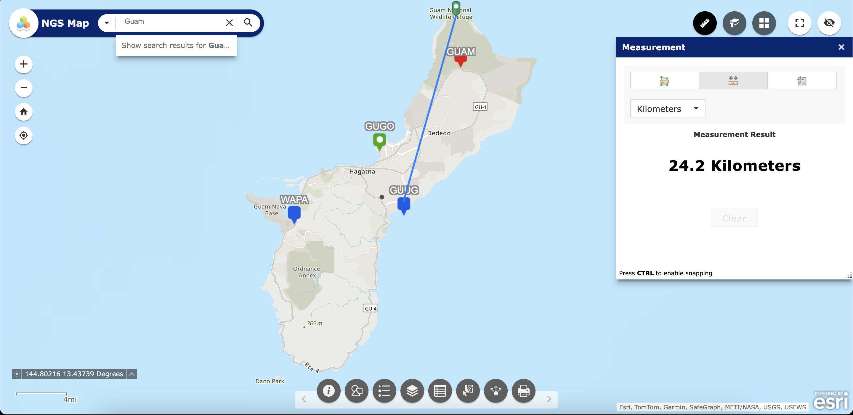
The results depend a lot on the CORS station used. The closest one (6.7 km away) has a logging interval of 30 s, the other two 1 s. The logging interval (set in Emlid Studio processing settings) of the receiver doesn’t affect much the result (cm level), but the used CORS gives a major difference (2 m!).
How can I estimate which correction is more reliable?
P.S. I assume that the logging interval of 0.2 s equals 5 Hz?
Could you share the raw data logs so I can check the quality? Thanks!
OK. Just let me know how you check the quality so that I can do it myself for all the other points afterwards.
Oh, the system won’t let me upload the raw data files … Lemme send you a link
Thank you. Here’s a guide on how to assess the quality of raw data.
Here is the link. Let me know if you have problems accessing the file.
RWC-N2 23_5 UTC 22_16 6h 45 min
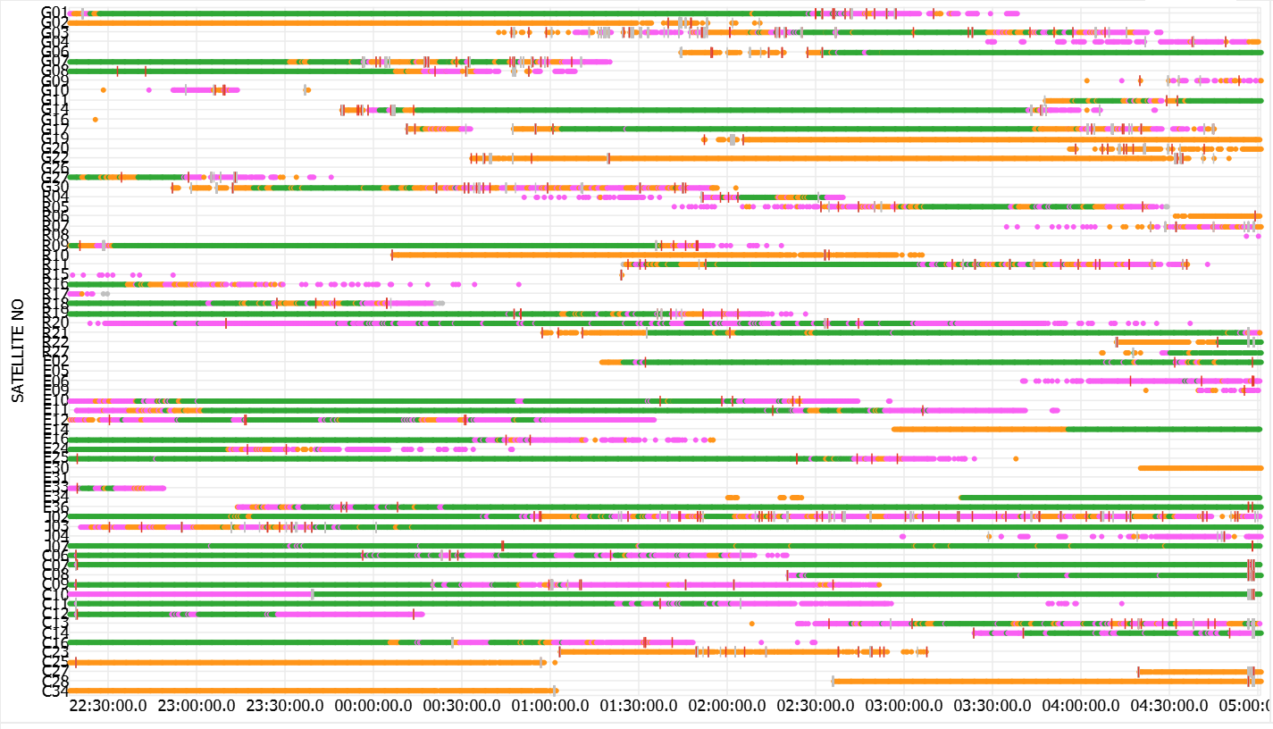
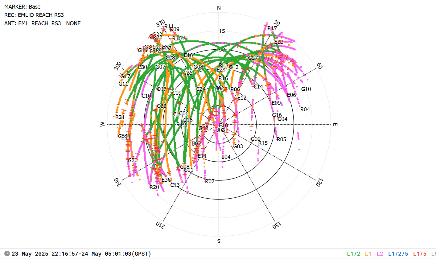
According to the guide that you sent, the quality seems to be OK; not many cycle slips and all the data has a SNR value above 35. The only thing is the satellite distribution - half of the sky is missing satellites, which was expected with the given cliff proximity. Anything else?
Hi, I uploaded your info to OPUS using their standard page5 processor (GPS Only) and here are their results.
Here is the result from OPUS with them choosing the CORS stations:
OPUS solution : Base_1_raw_20250523221637.25O OP1748363437548
opus opus@ngs.noaa.gov
11:32 AM (11 minutes ago)
to me
FILE: Base_1_raw_20250523221637.25O OP1748363437548
                          NGS OPUS SOLUTION REPORT
                          ========================
All computed coordinate accuracies are listed as peak-to-peak values.
For additional information: https://www.ngs.noaa.gov/OPUS/about.jsp#accuracy
DATE: May 27, 2025
RINEX FILE: base143w.25o TIME: 16:31:50 UTC
SOFTWARE: page5 2008.25 master271.pl 160321 START: 2025/05/23 22:17:00
EPHEMERIS: igr23675.eph [rapid] STOP: 2025/05/24 05:01:00
NAV FILE: brdc1430.25n OBS USED: 1457 / 2215 : 66%
ANT NAME: EML_REACH_RS3 NONE # FIXED AMB: 17 / 23 : 74%
ARP HEIGHT: 1.8 OVERALL RMS: 0.023(m)
REF FRAME: NAD_83(MA11)(EPOCH:2010.0000) ITRF2014 (EPOCH:2025.3919)
     X:     -5069351.620(m)   0.798(m)          -5069352.400(m)   0.798(m)
     Y:      3568220.476(m)   1.549(m)           3568222.291(m)   1.549(m)
     Z:      1495356.028(m)   0.512(m)           1495357.459(m)   0.512(m)

   LAT:   13 38 58.52951      0.316(m)        13 38 58.56184      0.316(m)
 E LON:  144 51 32.44363      1.008(m)       144 51 32.40918      1.008(m)
 W LON:  215  8 27.55637      1.008(m)       215  8 27.59082      1.008(m)
EL HGT:           82.406(m)   1.372(m)                84.378(m)   1.372(m)
ORTHO HGT: 27.607(m) 1.583(m) [ H = h-N (N = GEOID12B HGT)]
                    UTM COORDINATES    STATE PLANE COORDINATES
                     UTM (Zone 55)         SPC (5400   GU)
Northing (Y) [meters] 1509994.908 216552.778
Easting (X) [meters] 268398.804 111794.646
Convergence [degrees] -0.50546389 0.02572500
Point Scale 1.00026356 1.00000172
Combined Factor 1.00025060 0.99998876
US NATIONAL GRID DESIGNATOR: 55PBR6839909995(NAD 83)
BASE STATIONS USED
PID DESIGNATION LATITUDE LONGITUDE DISTANCE(m)
DR6550 CCJ2 CHICHIJIMA-A CORS ARP 1507636.3
DR4967 GUUG U OF GUAM CORS MON N132559.519 W2151150.205 24704.5
DR8470 AMME AMME NPSGISSAIPAN GRP N151302.359 W2141654.805 196637.7
NEAREST NGS PUBLISHED CONTROL POINT
TW0442 MACHANAO USE 1963 N133841.179 W2150817.911 606.9
This position and the above vector components were computed without any
knowledge by the National Geodetic Survey regarding the equipment or
field operating procedures used.
I know it is surprising they didn’t pull the three closet CORS stations, but that is typical of the the results they produce, at least it has been for me.
I have also submitted again to them manually choosing the three closet CORS stations, GUAM, GUUG, and also WAPA which they have rejected saying this:
“OPUS aborting : Base_1_raw_20250523221637.25O OP1748364733093
opus opus@ngs.noaa.gov
Site: wapa
1025 One of the CORS sites that was selected from the pull-down menu
1025 is not available for the day in question or it did not meet the
1025 quality control requirements. Please select another CORS site
1025 to be included in the processing and re-submit the data.
1025”
They also said the same thing for the GUAM CORS station.
Here is OPUS using GPS, GLO, GAL.
Note: fixed ambiguity of 23% is well below the recommended > 50%.
FINAL ESTIMATED COORDINATES [STATE PLANE COORDINATES SPC (5400      GU)]
Northing:           216552.369(m)                0.000(ift)
Easting:            111795.438(m)                0.000(ift)
Orthometric Height:     27.953(m)         0.000(ift) ( H = h-N (N = GEOID12B HGT))
Rover RINEX Version: 3.03          GNSS Requested:GRE

BASELINE BASE STATIONS AND STATISTICS
PID     STATION ID   GNSS  LENGTH (km)  RMS (m)      FIXED AMB       OBS USED
        DARW00AUS      GR    3261.2313   0.0191       0:  0.0%     616: 62.7%
AF9627  GUAM00GUM      GR       6.7451   0.0184       3: 16.7%    4678: 81.2%
DF7984  GUUG00USA      GR      24.7040   0.0209       7: 33.3%    5891: 85.7%

                              NGS OPUS SOLUTION REPORT
                              ========================

All computed coordinate accuracies are listed as peak-to-peak values.
For additional information: https://www.ngs.noaa.gov/OPUS/about.jsp#accuracy

                             DATE: May 27, 2025
RINEX FILE: base143w.25o                                 TIME: 17:13:09 UTC


  SOFTWARE: M-PAGES  0.8.3 master292.pl 1603213         START: 2025/05/23 22:17:00
 EPHEMERIS: GFZ0MGXRAP_20251430000_01D_05M_ORB.SP3       STOP: 2025/05/24 04:55:00
  NAV FILE: brdc1430.25n                             OBS USED: 11185 / 13610   :  82%
  ANT NAME: EML_REACH_RS3   NONE                  # FIXED AMB:    10 /    43   :  23%
ARP HEIGHT: 1.8                                   OVERALL RMS: 0.019(m)


 REF FRAME: NAD_83(MA11)(EPOCH:2010.0000)              ITRF2014 (EPOCH:2025.3920)

         X:     -5069352.429(m)   0.134(m)          -5069353.209(m)   0.134(m)
         Y:      3568220.079(m)   0.258(m)           3568221.894(m)   0.258(m)
         Z:      1495355.712(m)   0.149(m)           1495357.143(m)   0.149(m)

       LAT:   13 38 58.51619      0.114(m)        13 38 58.54852      0.114(m)
     E LON:  144 51 32.46995      0.219(m)       144 51 32.43550      0.219(m)
     W LON:  215  8 27.53005      0.219(m)       215  8 27.56450      0.219(m)
    EL HGT:           82.752(m)   0.239(m)                84.725(m)   0.239(m)
 ORTHO HGT:           27.953(m)   0.282(m) [ H = h-N (N = GEOID12B HGT)]

                        UTM COORDINATES    STATE PLANE COORDINATES
                         UTM (Zone 55)         SPC (5400   GU)
Northing (Y) [meters]     1509994.492           216552.369
Easting (X)  [meters]      268399.592           111795.438
Convergence  [degrees]    -0.50546111           0.02572778
Point Scale                1.00026355           1.00000172
Combined Factor            1.00025053           0.99998871

US NATIONAL GRID DESIGNATOR: 55PBR6840009994(NAD 83)


                              BASE STATIONS USED
PID       DESIGNATION                        LATITUDE    LONGITUDE DISTANCE(m)
       DARW                                                         3261231.3
AF9627 GUAM USGS GUAM OBSERV CORS ARP      N133521.556 W2150753.872    6745.1
DF7984 GUUG U OF GUAM CORS ARP             N132559.519 W2151150.205   24704.0

                 NEAREST NGS PUBLISHED CONTROL POINT
TW0442      MACHANAO USE 1963              N133841.179 W2150817.911     606.2

This position and the above vector components were computed without any
knowledge by the National Geodetic Survey regarding the equipment or
field operating procedures used.
Oh wow!
Thank you a lot @dpitman and @mark1st.john!
Is the column next to the ortho height (1.372 m for @mark1st.john and 0.282 m for @dpitman 's solution) the error bar?
Based on what can someone decide which result is more accurate?
And crucially, would e.g. recording for 24 h improve the results?
Thank you again ~~