I’d need to measure elevations of points under a 150 m cliff and quite thick vegetation. There is a benchmark though 2-3 km away, and even a CORS 15 km away. What method would you suggest for such conditions? RTK with the base over the benchmark, Rover only with CORS, or? Either way, what should be the measuring time over the unknown spot?
Targeted accuracy is 0.1 m. In wide open space there are usually 42 satellites available (so I probably ca. 20 under the cliff). Elevation is key.
How thick is the vegetation? Could you maybe share a satellite view of the area of interest? GNSS is generally not recommended for sites with such environmental conditions, as it relies on a clear view of satellites, among other things, for accurate position computation.
Also, how many points do you need to measure on the field?
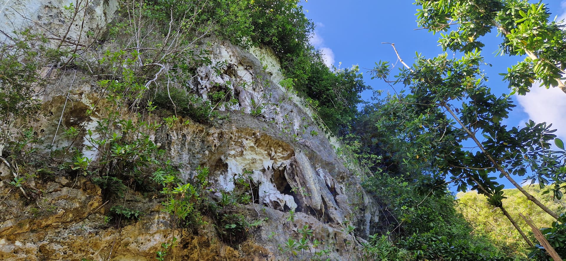
During dry deason it’s not super thick, more like some Mediterranean forest and it may have some semi-openings. Attaching the most challenging area satellite view and examples of the forest. The mentioned benchmark is in a wide open space. Id need like 5 points in a span of 3 km.
Maybe cell service in what appears to be Guam refuge area? Or Starlink? Set base on known point (MANUAL) try LoRa and see what you get… if unsuccessful, PPK Stop & Go or use cell/Starlink and use CORS with ROVER only or set base on known point, MANUAL POINT, then send corrections via NTRIP from base to rover. Or CORS to BASE (AVERAGE Fixed, save point manually) then to rover via ntrip.
LiDAR.
Too bad the units don’t send UHF (just receive) (not to mention L1, L2, L5, etc… YET), so the base would have to have UHF radio added.
Thanks for the pictures. It seems like a LoRa connection would be challenging here. Is there a stable internet connection in this area?
Also, the last picture shows that achieving a FIX solution might be challenging as the trees block the view of the sky. These obstacles will likely result in multipath and cycle slips, which would affect the accuracy of your survey.
Yes, no internet in that area. It would need to involve some post processing technique imho. And the selecting the proper acquisition time the challenge. But wanted to have more input from experience of other Emlid surveyors or the Emlid Team.
Thank you. Would you have any links to pages that describe more in details PPK Stop & Go you could share right of the bat (of course I can Google)?
For Starlink D2C (didn’t know it was available already) with CORS-Rover method, how long would you measure a point with the Rover to get 0.1 m vertical accuracy in the given conditions (vegetation, cliff)?
I got an estimate with Lidar, but if the exact location of the point cannot be determined, the Lidar estimates have 0.5 to 1 m error bar.
Total station or differential leveling is off the table 'cos they won’t let us cut any low vegetation as some endangered species live on the bottom sides of the leaves.
P.S.: D2C service seems to be provided only through T-mobile, which doesn’t have its own network on Guam. Would need to first make sure if they offer Starlink D2C service here. Still post processing options seem to be more realistic.
You will need to do some mission planning in order to determine the best time of day for the most SV’s viewable.
I’d use two base static receivers and a static rover. Set up your two base units apart at least the length of your project site. Use your rover as static also and log a minimum of 30 minutes per point. Log the fastest at 10hz for all receivers.
The methodology behind this is you’ll have a closed loop GNSS traverse for each point. You’ll end up with 3 vectors for each point. This will give you the confidence in each point measured as you’ll have a closed loop and you’ll know the accuracy of each point after post processing.
Thanks for sharing. I only have 2 receivers though.
I measured the distances now a bit more carefully; the most remote point is ~1 km from a benchmark, and 7 km from CORS.
GNSS may not be the way to go. The first thought is a combination of GNSS and more traditional methods using each where you can. So maybe no vegetation damage/clearance for line-of-sight methods is a problem? What about a barometer?
You may be able to meet your one decimeter height accuracy requirement with a barometric instrument especially if you can move from a known height to your unknown height in minutes versus hours. An appropriate barometric sensor may not be that expensive depending on how how long it takes to move from point to point. Really cheap sensors even 20 years ago could do submeter elevation differences over the course of minutes. Obviously you can’t do this during the passage of a storm, but if the vegetation is dense enough and you can’t damage it and you can move from a known elevation within minutes (or?) to the unknown spot I’d think about a barometer.
If you can do it multiple times you get a repeatability level and at certain spots perhaps a good GNSS position to compare and you’ll know if your data is good.
For GNSS in somewhat similar situations I’ve got sub-decimeter heights, but needed multiple hours of data to ensure this. That said I did it when the water in the vegetation was at a minimum. At other times the results would not be that good.
Thank you for your answer. May consider a barometer in the future.
As for vegetation, now it’s the best time as we are at the end of a very dry season and the foliage is really reduced and so must be the water.
My 2c. As on observation when using RTK and using emlid flow. When I get close to trees, the horizontal accuracy is still ok ( 5cm) but the vertical can be up to 0.5m out. and the only indication would be a slightly higher PDOP. Whereas you would still get a “fix”