Sidebar Geek Topic - So, one OPUS evaluation was done at ARP height of zero, and another one at measured ARP height. Question is could the measured ARP height be corrected and determined by comparing both tests?
OPUS: If ARP HGT = 0.0, OPUS solves for the position of your selected antenna’s reference point (ARP).
Example: Ellipsoid Height
495.642 OPUS at zero [phase center calc corrected]
494.025 OPUS at ARP HEIGHT set to 1.630 meters
1.617 mm [subtraction]
1,630 mm [ARP entered value in OPUS]
1.617 mm
So, a 13 mm difference, which might be added to measured ARP height.
I wonder how CORS finds their correct ARP height? I do know that “NGS uses two weeks of data to ensure that any new station is stable in all three positional components (latitude, longitude, ellipsoid height) before they will allow the station into the network.”
Technically yes, but consider the error in the computed position in both horizontal and vertical components and what the APC is for the particular antenna. There is actually two different APC for the L1/L2 frequencies.
There’s no way to accurately determine the ARP in the method you’re trying to use.
The individual CORS antennas typically use a “0” ARP (bottom of mount point). You still have to consider the error in the computed height of position. OPUS is not perfect, no system is. There are many errors to consider. I’m sure you have read
and
Even in the CORS themselves there is error uncertainty. Select any station from the above link and you’ll see the error uncertainty in the computed position at the ARP. Have you also considered plate tectonics ? That’s why the CORS positions are fixed to the current epoch time NAD83 (2011) EPOCH 2010.000
Earth rotational effects also have an effect on error
Have you also considered subsidence of the measured point ? Many CORS also take this error probability into account. Consider the plate movement in the western regions of the USA
You can verify the CORS positions by post processing individual baselines between them. NGS does this on an hourly basis I believe. I sometimes do this myself out of curiosity; a good commercial or institutional post processing software is required.
Determining a points position even with long term observations (days, months or years), there is uncertainty in the computed position, not to mention the physical determination of the ARP.
Why introduce another error of uncertainty ?
Physically measure the ARP in both feet and meters if you are determining a physical ground mark
Via email, I’m assisting a newbie on how to setup his RTK base station, which was originally setup at zero ARP by streaming NTRIP from a CORS like quality base station some 20km away. After crunching OPUS results (with and without measured ARP, and with/without antenna-name), I realized I could synthesize a better ARP.
Yes, I know this is an ‘off the chart’ evaluation, but for what ever reason, it appeared to work out mathematically, this time:-).
[quote=“EBE111057, post:5, topic:41917”]
The individual CORS antennas typically use a “0” ARP (bottom of mount point)[/quote]
Tidbits
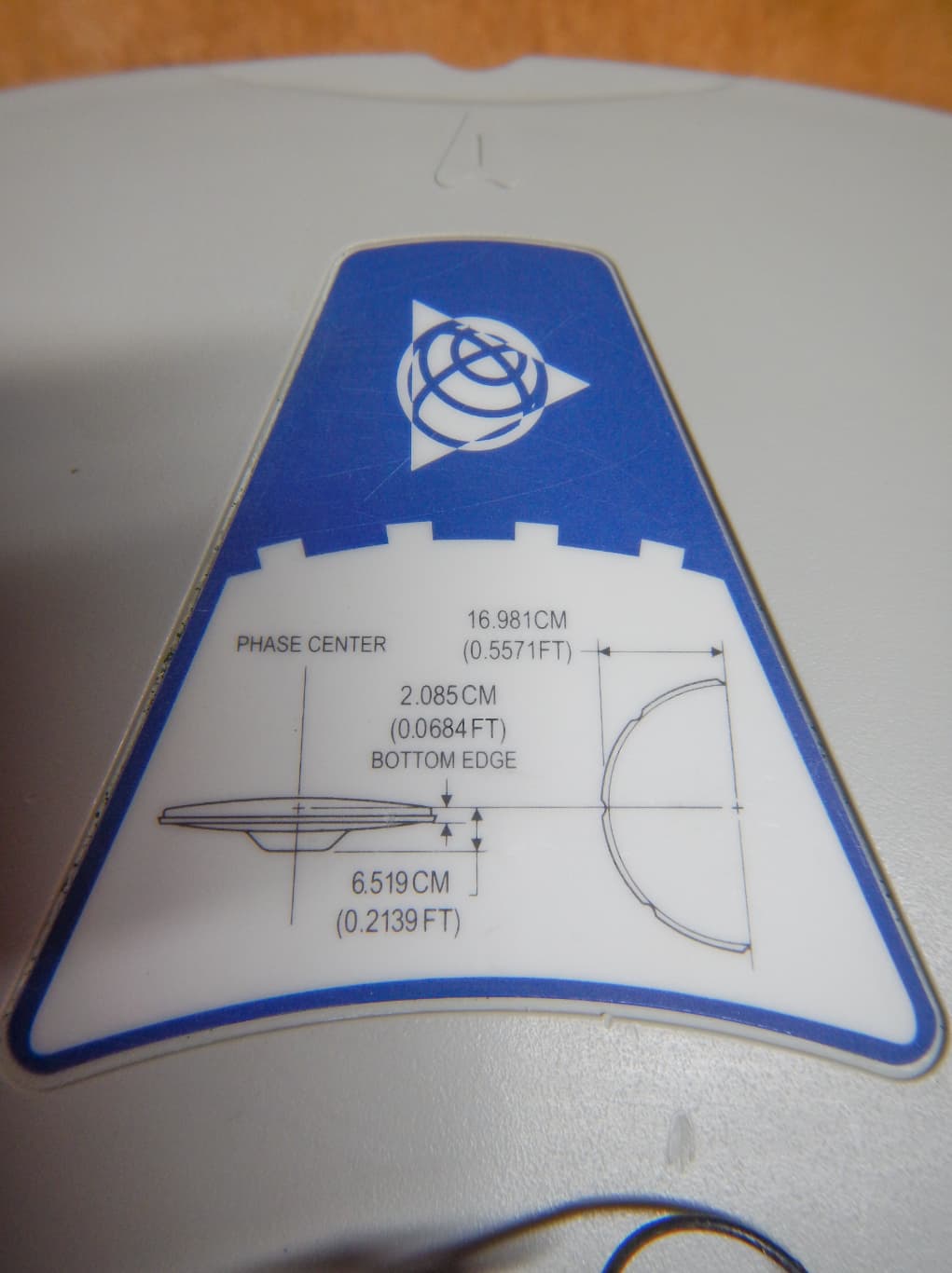
When a position for a CORS is computed or published, it may be expressed either directly for the antenna phase center or for a nearby monumented point and an offset from that monumented point (for example, this information might be given by the position for a mark located directly beneath the antenna and the height of the antenna above the mark). Although the position of the antenna itself is usually of most interest, a permanently and stably monumented point of reference should always be established and the offset to the antenna determined.
As far as determining a new position for a ground mark and/or passive control station, use of the NGS reference ARP mark (“0” in most cases) prevents confusion in using the CORS APC in commercial post processing software.
Antenna ARP of “0” from CORS are a physical mark and have published coordinates. In many cases if the CORS ARP is physically visible from the ground, a reference mark position can be determined from trigonometric means; i.e. by using a Trimble S6 robot.
Antenna “0” ARP’s are part of the NSRS passive control mark inventory.
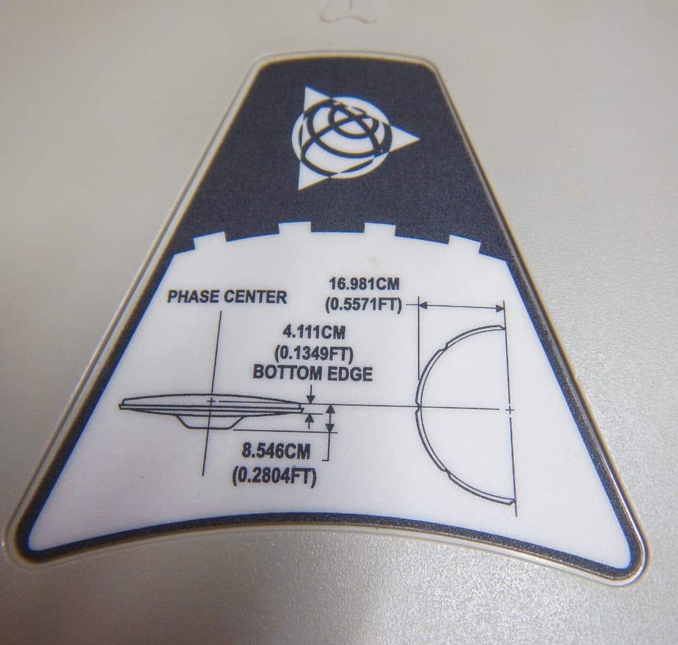
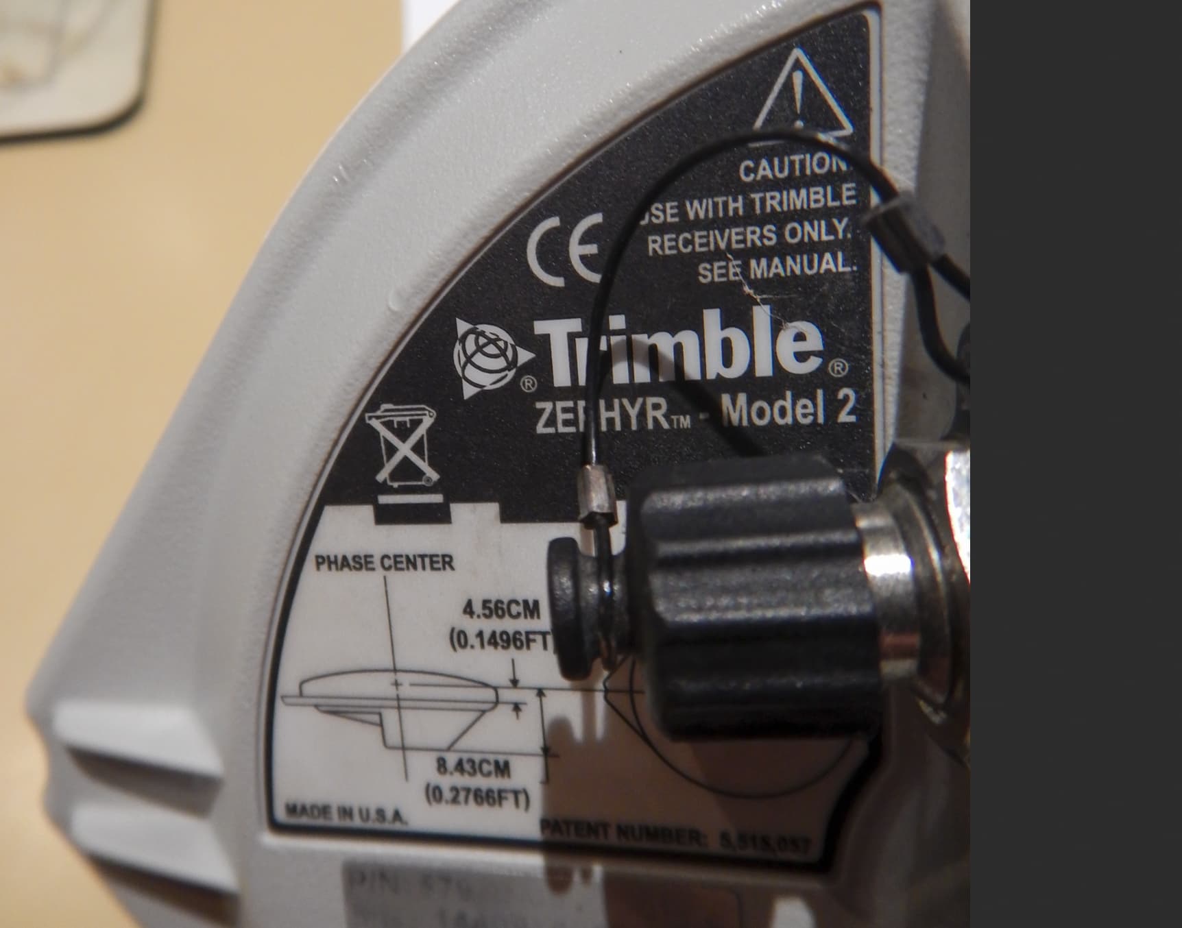
Note that the ARP usually corresponds to the center point on the bottom of the pre-amp on the CORS antenna.
…
We supply 2 positions for our CORS users: the L1 Phase Center (L1PC), and the center of the bottom of the antenna which we call the antenna reference point (ARP). We supply these positions in 2 reference frames, NAD83 (2011,MA11,PA11)epoch 2010.00 and ITRF2014 (epoch 2010.0) . We do not use the WGS84 to position points.
The longer the baseline between base (NTRIP station) and rover, the lower the resulting accuracy. Uncertainty increases by ~1 mm per
km distance on top of the ~1 cm initial uncertainty
Ok, using a CORS like base station with rover (farm RTK base station) at some 20 km distance at 240° compass direction, and with only one OPUS evaluation, I found a deviation of 27 mm in latitude, and 2mm in longitude, with respect to the rover.
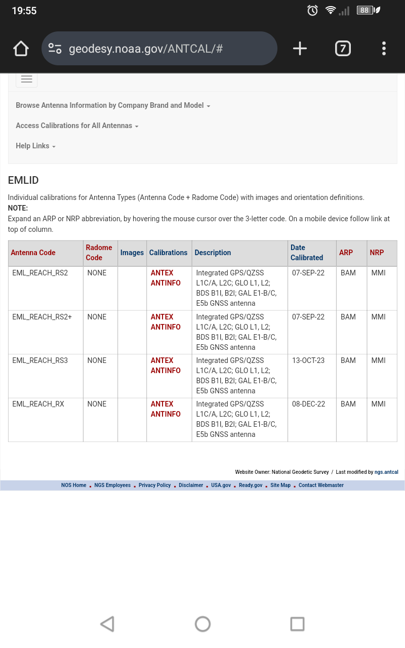
Although there’s no drawing available of Emlids equipment provided in the NGS antenna calibration database, the ARP for the RS2 and others is the BAM (bottom of antenna mount)
If using a Windows desktop/laptop computer, the find command (CTRL + F) could be used with ARP inserted for searching NGS FAQ
My socks are white, I just cited the source.
Btw, on my second inquiry about baseline accuracy in terms of why latitude was affected the most, but not longitude, I did find this tidbit info below, but just the generic explanation. Another loose end…
RE: “Suitable as an introductory textbook for graduate students as well as a reference for scientists and engineers”
Well then, one more time explaining this trivial example in regards to RTK Accuracy and Its Dependence on Distance from the Base Station.
Rover obtained its coordinates at 20km distance from a CORS like base station (240° compass direction from each other) via NTRIP.
Rover using a calibrated antenna determined its coordinates (XYZ & ELL) via OPUS showed expected textbook value of 27mm offset in latitude, but longitude had 2mm offset.
Why don’t latitude and longitude have similar numerical offset values?