Has anyone used this drone with rs2+?
The evo 2 8k is available refurbished and wondering how it works together. I’m looking to use it for land mapping for design purposes.
Thanks.
Has anyone used this drone with rs2+?
The evo 2 8k is available refurbished and wondering how it works together. I’m looking to use it for land mapping for design purposes.
Thanks.
If you are not going to use an RTK or PPK capable drone, I would suggest you look at the Phantom 4 Pro. With the P4P you get a larger imaging sensor, a mechanical shutter, and a lot more options for flight software via the SDK.
Either craft really has no direct connection to an Emlid receiver. But of course you could use the RS2+ to establish your ground control and checkpoints. In that case, you would typically need an NTRIP correction service, or 2 receivers, for example an RS2+ and an RX or RS2 for a base - rover workflow.
Hi @maverickgood1,
I’ve also just checked the EVO 2 8K model doesn’t support RTK. And also, its camera doesn’t seem to provide a hot-shoe access for PPK mapping. So, as Dave said, with this drone, you can only place ground control points to improve accuracy.
Which drone do you suggest?
Thanks.
It depends on what you are trying to accomplish and your expectations. Let’s start there. These are tools. The best tool depends on what you are trying to build.
I’m looking to map a property out. To give me a topological map from above. With elevations. I’ll use that as a site image with exact current tree locations. From there I can design house and other structure locations. Calculate exact measurements of driveway width and lengths. Calculate rock/gravel requirements.
Eventually, after I figure this out I’ll do this for clients. I’ll use drone images to construct 3d models for clients.
This is what I’m looking to do.
Is the site mostly open and not heavily covered by trees or tall vegetation?
Do you need for the coordinates to line up with any particular projected reference system or do you just need the topography of the site itself?
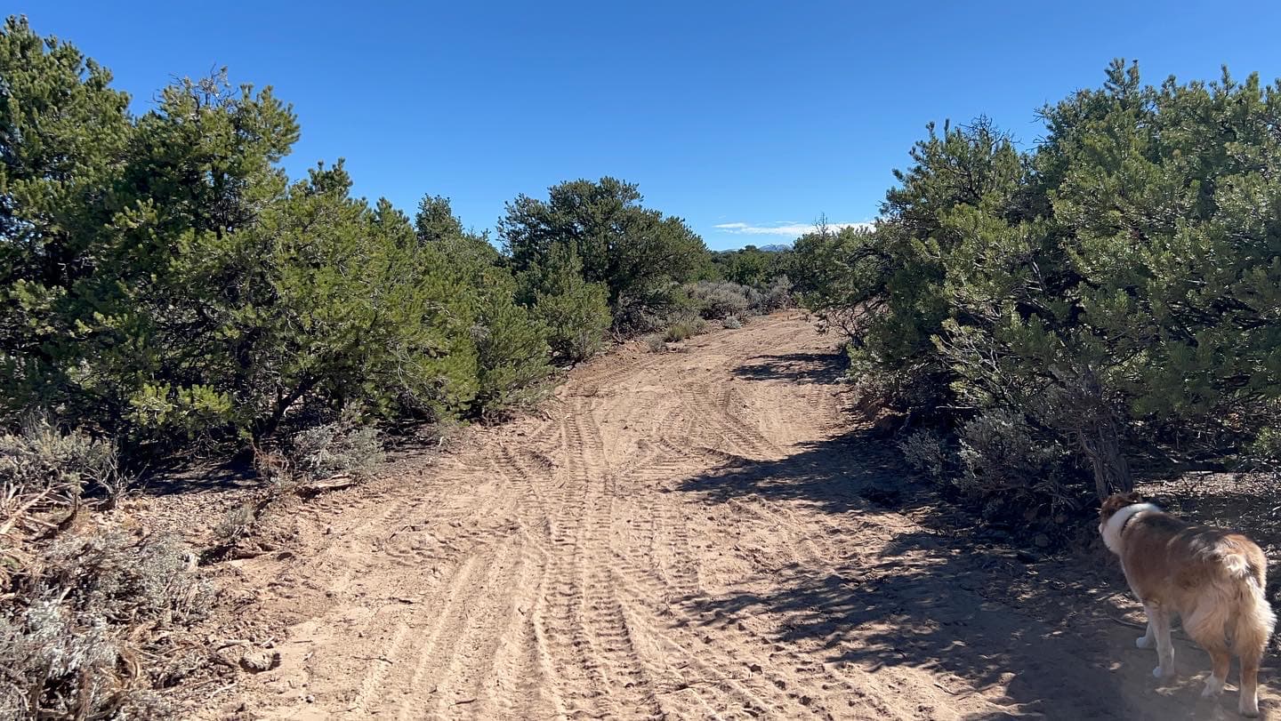
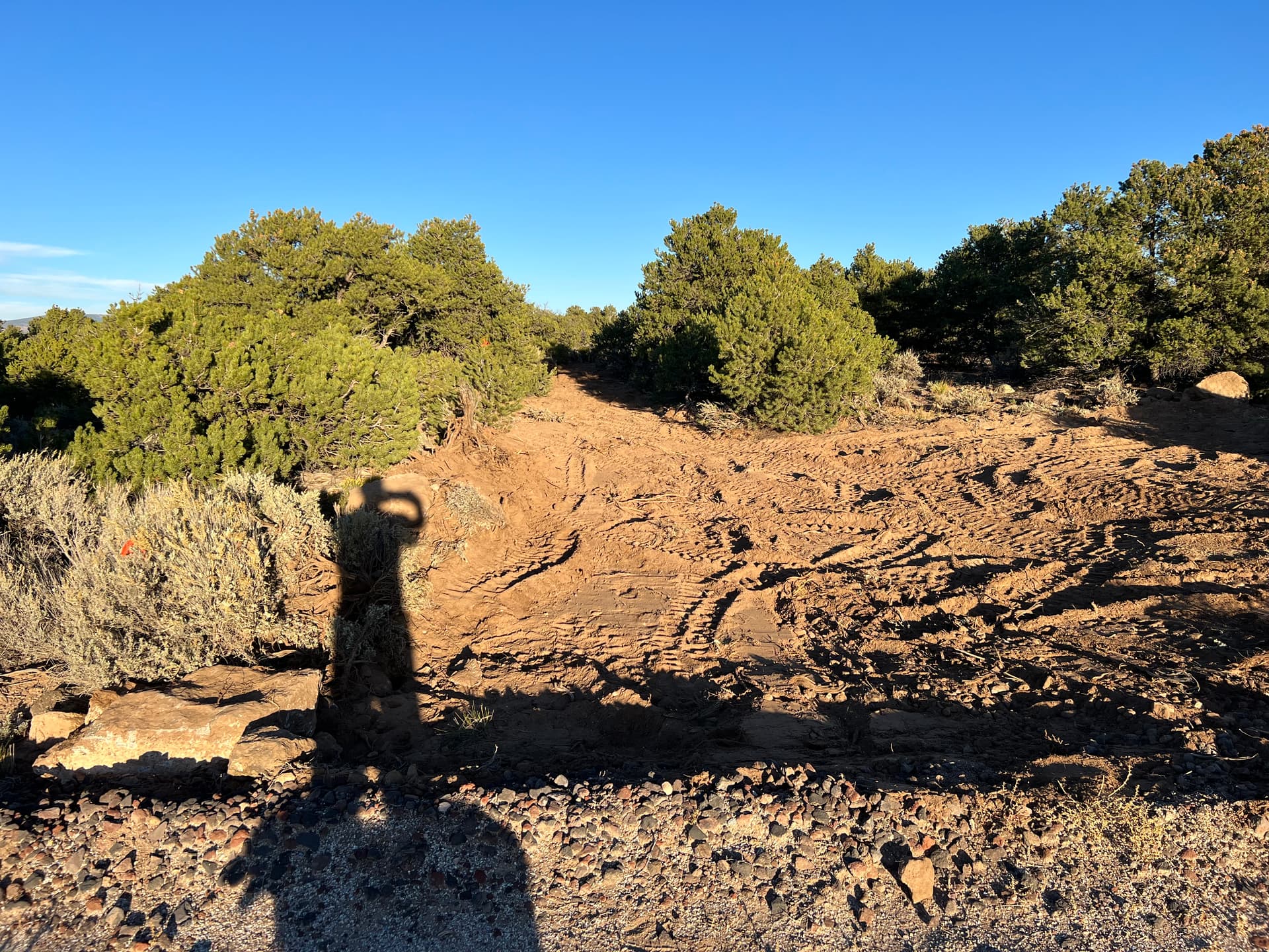
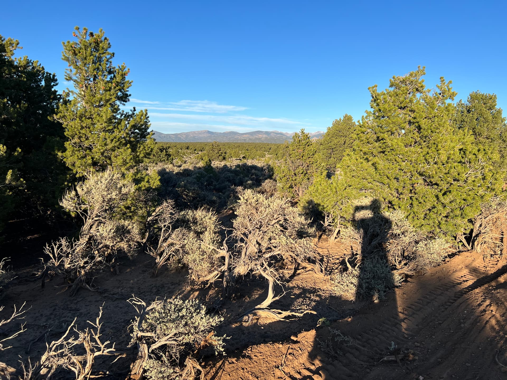
Well, in this one case there are plenty of trees from small to 30ft high. Here are some examples. It would be good to know the gps locations so setbacks and borders can be known.
Some of the property is open. Mostly sage brush. The rest of it has a lot of trees.
In that type of terrain, you can get a good terrain model of the open areas. Any areas with trees and brush will be extrapolated from the nearest open areas.
Whether you use an RTK/PPK capable drone or one without, this will be true.
If you want to be able to utilize RTK or PPK workflows, you will need to get a craft that has that ability built in, or buy a craft that has a precision gnss kit available to add on. Some DJI craft use the moniker “RTK” in a misleading way. It refers to the navigation system but does not timestamp imagery with precise location and gps time needed for survey RTK.
Some current (survey) oem RTK craft are:
DJI P4RTK
Autel Evo2 RTK
Autel Evo2 Enterprise RTK
DJI M30
DJI Mavic 3 Enterprise (should be good but is new and untested)
DJI craft have geofencing if that is of concern.
Autel craft generally lack SDK support.
If you don’t need RTK/PPK, at least to get started, then a lot of consumer drones will work, including the one you mentioned in the beginning. It’s just not the best choice.
The better the imaging sensor, and a mechanical vs. electronic shutter are factors. Wind resistance and battery life (air time) may be factors too. So long as your projects are not too large, and you have good image sets, you can achieve good “relative” precision without RTK/PPK. You will be able to measure distance and work with volumes, etc.
As I said in the beginning, the DJI P4 Pro is still probably the best non-rtk consumer craft for mapping. But guys are using almost all of the current craft for occasional “mapping” even though the craft is not the “best” choice.
When using proper Ground control (GCPs and Checkpoints), models created with these craft can be aligned with projected coordinate systems too.
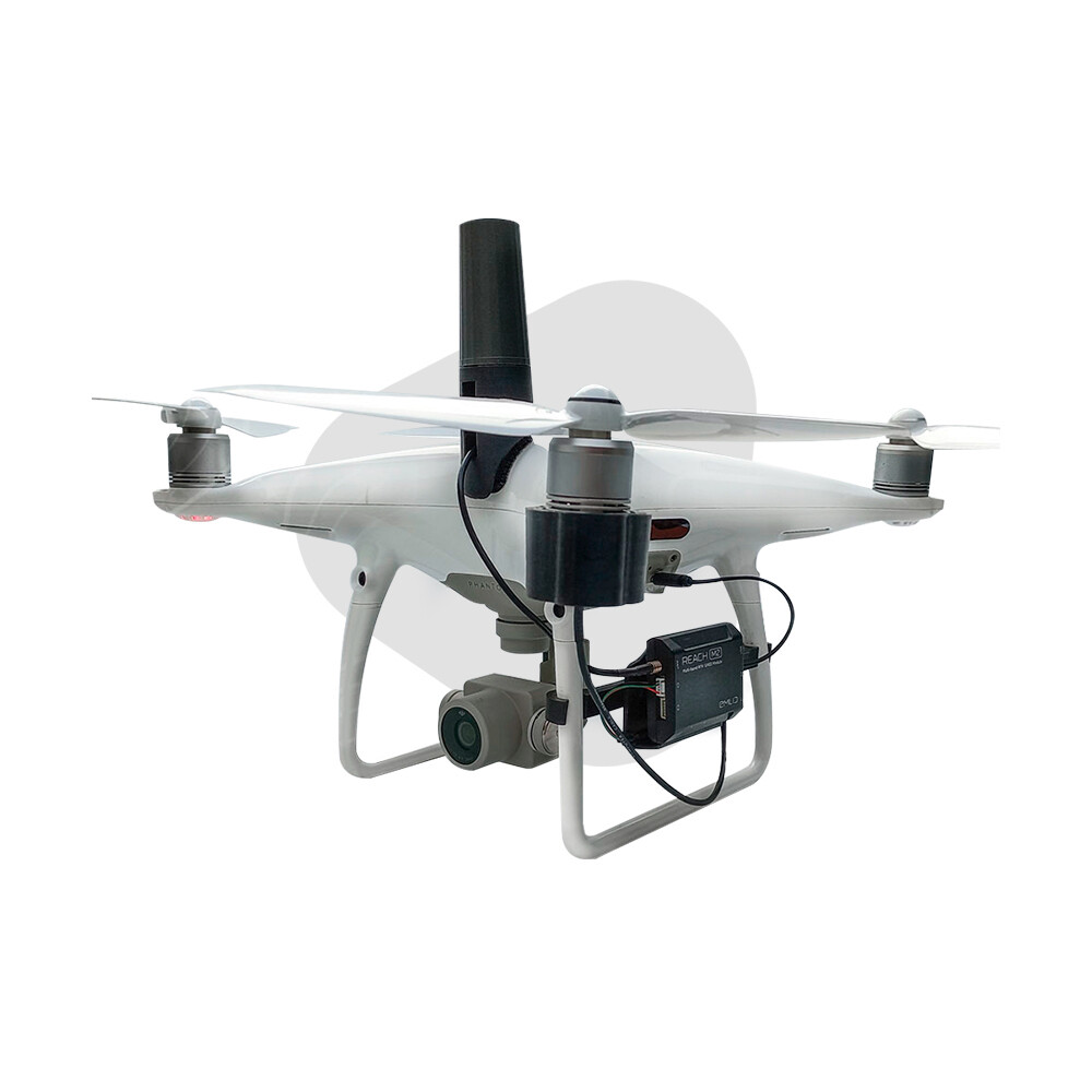
Also, with the DJI Phantom 4 Pro model, you can look into using this add-on kit for PPK if you don’t want to go with the more expensive RTK models.
$299
The Kit PPK Phantom 4 Pro is a non-intrusive adapter system for connecting an Emlid Reach M2 or M+ GNSS receiver (not included) to a DJI Phantom 4 Pro or Advance model drone.
Main advantages:
Works with M2 and M+ modules
No need to open or modify the drone
Kit attaches and detaches in seconds
No batteries required
Ultra-fast image triggering detector sensor
Includes an LED light to verify the capture of each photographic shot from the drone camera
Light weight micro electronics: 70 grams
Heat and cold resistant materials for operation in extreme climates
Optional: Battery Add-on to keep the M2 on when changing drone batteries
I believe there are people on this forum that have had decent results using the system.
I actually had purchased one of their units for my DJI Phantom 4 Pro V2, but haven’t time to test it since I found a deal with an Autel RTK unit and have been busy with that system.
Autel is having a sale right now on their Autel Robotics EVO II Pro 6K Enterprise Rugged Bundle V2 because of the upcoming release of V3 units.
$4,099.00 $5,123.00 saving $1,024.00 with the included RTK Module
Their Autel Robotics EVO II Pro RTK 6K Drone Rugged Bundle is on also on s.ale
$3,299.00 $3,881.00 saving $582.00
And TOPODRONE offers PPK Upgrade Kits also for the DJI Phantom 4 Pro
For creating an elevation map will any of these drones work?
I wonder what their v3 is going to have.
Does anyone here have any examples of output or final product from drone maps I can see? As it pertains to land/site design or topography?
That ppk kit looks pretty good. It sounds better than paying thousands extra for a more capable drone.
Yes
I see. Two images of site location and one elevation map?
Do you get into any additional services like design work for clients? Or they take these deliverables and find an architect to do that?
We have never been asked for design. Only for current conditions and/or tracking topography and/or site conditions over time. So, no, currently, we do not offer design. Design would expose us to a lot more liability as well.
Where I’m at you can’t get a survey guy to come out and do anything. Everyone is booked for months. I’ve been at this since June. It’s now oct and still no survey guy. That’s one problem.
Second problem is once you have a survey with elevations then you need to design out what you want. No local architects here either ![]()
So that leaves a lot of time to do something. Might as well start designing things and getting a head start. Once you find an architect most of the initial work is already done. This is what I want to offer to clients.
At this point no one is locally offering anything. No survey. No design work. No drone photography. Nothing.
How did you do the elevation map? With a drone or manually?