At this point, of the long road map, these devices really need more energy put into TILT COMPENSATION.
Not to mention LOCALIZATION implemented in the app also.
Maybe a poll of what users need to illustrate the importance?
At this point, of the long road map, these devices really need more energy put into TILT COMPENSATION.
Not to mention LOCALIZATION implemented in the app also.
Maybe a poll of what users need to illustrate the importance?
does it mean the phone is receiving the correction from the base and then the phone transfer the correction thru bluetooth to reach rx.
ok, that’s too bad about no PPK, I was almost ready to pull the trigger on one. So it must not have any substantial memory to record log files for later PPK processing. I get it I guess, you have to give up something in order to get the size and weight reduced down to where Emlid did for the RX receiver. I do like the form factor, but I’ll just have to save my money for when the new Emlid “RS3” comes out. Maybe with the new Septentrio Mosaic-X5 chip with GPS L5, L Band w/SSR corrections and 448 channels! ![]()
@willstar_beleno Yes, you have it right.
would you like to sell your rs2+ to me ?
please can it be used with a phantom 4 rtk for ntrip drome mapping? so i can purchase 1
Hi Caleb, The RX can only receive NTRIP corrections and act as the rover. It is ideal for setting ground control points!
To send corrections to a Phantom 4 RTK (or other RTK drones) you would use the RS2 or RS2+ and Emlid Caster or Local NTRIP.
Does this unit have to have RTK corrections? What is the accuracy like without RTK?
Can someone explain to me why someone would buy this instead of the RS+?
Does it have better range to the NTRIP than the RS+?
Does anyone know the recommended maximum range to an NTRIP tower/station for the Rx?
Rs+ is single band, rx is dual band like the RS2 L1/L2. So it fixes much faster, and under partial obstruction unlike the RS+.
With all RTK except VRS, the shorter the baseline the better for precise measurements. The max distance relates to how accurate you expect it to perform.
Just because it fixes at 375km from base does not mean the data is guaranteed to be accurate.
Hi Ryan,
Reach RX is an RTK rover, so corrections are necessary to get centimeter accurate solution. Without them, it will provide a few-meters accuracy level.
Hi Leighton,
The RX is meant to be a light weight precision rover. For jobs where you are walking about a project collecting points the light weight RX is easier to handle and plumb without using a bi or tripod. Also, the settings are kept simple so that it is user friendly for crew members that may not fully understand all of the proper setup on the RS units.
Hi Leighton,
@dpitman and @PotatoFarmer have highlighted the difference, and I have a bit more to add here.
Reach RS+ is a single-band device while Reach RX is multi-band. If you choose an RS+ device, you’ll need to provide it with the clear sky view to get the best out of it. Reach RX, in its turn, can work in more challenging conditions with particularly blocked sky view.
The more details about the differences between single- and multi-band receivers are in our docs.
It should work fine with the baseline up to 60 km.
There’s chatter at the Commercial UAV Expo about the RX! I’ve already had a few people asking about it.
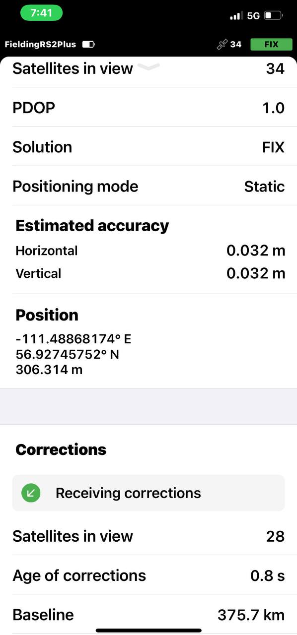
Fixing in real-time this far from the base is concerning ![]()
Is that because of the Static positioning mode ?
This is not the record for longest fix another forum member has me beat by a long shot. I just cant find the post.
Static mode assumes the rover is perfectly stationary to assist getting a fix. It took about 5 minutes to get it.
Trying to do this in kinematic would not work.
I see, this is indeed a great constraint to help on ambiguity fixing. Thank you ![]()
Happy to represent Team Emlid that the Commercial UAV Expo! Had a great panel discussion over construction and many good questions afterwards.
Boy do these drone service providers need to get some geospatial training. Number one barrier in survey grade construction mapping. Knowing the difference between geodetic, surface and grid is a must when you are trying to coordinate with other sources of data on different datums and because construction uses localization it’s never perfectly aligned. It can get very close but even the best one I’ve ever seen aligned still introduced error into that workflow and when you are fighting for every 0.10ft you can get it’s one of those things you have to pay attention to.
Shout out to my buddy @bill.stettner.
Hey guys!
If you’re in doubt whether Reach RX is what you need, here is the post you can find useful:
Ahh good to know. So not sub-meter without RTK then?