Windows Tablet Survey Application

Hey Everyone,

I’ve been working at a few different projects lately with the Reach. I wanted to have similar functionality to the survey controllers I currently use for work, ie - single point storage, point stake-out, offline map.

With little to be found on the Android Market I found myself looking to other cheap and alternative routes. I had an old HP Stream 7 tablet kicking around and with luck, it had blue tooth.

It doesn’t take long to find the libraries you need to make a simple application such as thing - but I’m extremely rusty with my coding (been about 10 years now.). But I’m ranting… Here are some screen shots and a list of the features it has so far. I’ll post the app itself in the next couple of days after I clean up the code a bit.

Features:
Coordinate Transformations
Single Point Storage
Single Point Stake-out
Map (shows currently location and uses a map SHP file for your offline map)
Antenna Height Correction
Bluetooth Connectivity

Screen Shots:

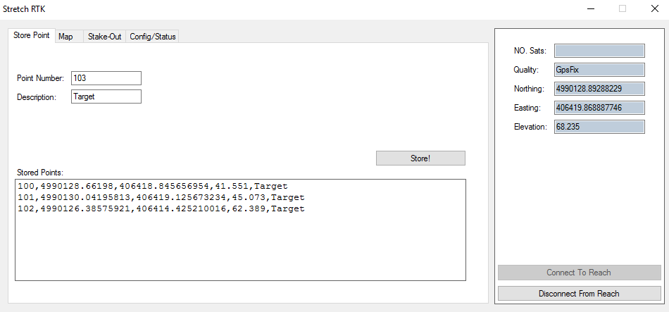
Single Point Storage:
I have it set to store the Local N/E/Z as of right now. I personally don’t use lat/long for much.

Map:
The red dot indicates your current location, the black lines are road shape file I had for my town.
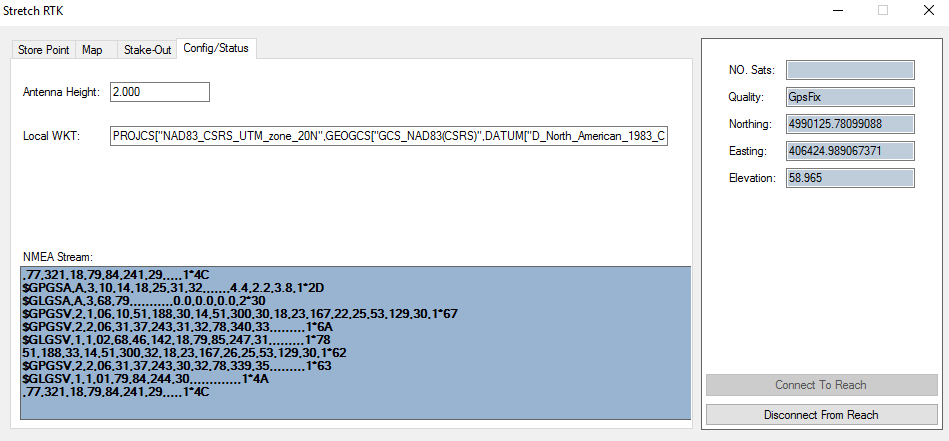
Config:
To change to your local projection or system, simply use your own WKT for your coordinate systems definition. The Antenna Height can also be changed depending on your rod height.

I’ll post the stake-out tab later, it’s still a bit of a mess.

If there are any other features you can think of that could be added, let me know.

3 Likes

I’ve been trying to find a decent Android solution too but coming up a little short. Have you seen this thread? Reach View or Other Surveying Software. ESRI Collector just added high accuracy GNSS support. It’s free. I will test it out soon with my Reach.

What platforms does your app run on and what is it written in?

A couple features for your app would be grid layout, topo survey, and guidance.

@savvy0816
Topo Survey would be single point survey storage, or do you mean a continuous topo (similar to Trimble), ie fixed distance interval or timed?

The application is written in c#, I’ve tested it on Windows 7, 8, 8.1 and 10 thus far. My tablet runs 8.1 (please don’t boo me!)

Grid Layout ? Do you mean point to point, or point layout in grid coordinates ?

Topo survey - continuous or point mode. I like both but would use point mode more.

Grid - Yes I mean point to point. When in the field, it’s nice to lay out a grid of points in x and y quickly for environmental test sampling,etc. Choose an origin, orientation, and spacing and hit go.

Well, After a little bit of work I’ve got an Alpha release of my App, I’ll attach it to this post.

A couple of things to note:

  • You will need to be running ReachView 2.0 for Bluetooth → Windows Connections
  • First Pair your Reach with windows before running the app.

The file “default.xml” is the main configuration file for the app itself. Also it acts as a job file and can all points will be stored inside xml file itself. My recommendation is to copy the default file and rename it for each of the jobs you wish you do. On that note, you will also need to do a bit of editing prior to running the app. You will need to find your Local Transformation WKT text to enter.

For those of you who are not familiar with projected transformations, the WKT simply defines the parameters used to transform your WGS’84 to your local datum, ie: UTM Z12.

Here is an example of a WKT, and also the one I use here:
PROJCS["NAD83_CSRS_UTM_zone_20N",GEOGCS["GCS_NAD83(CSRS)",DATUM["D_North_American_1983_CSRS98",SPHEROID["GRS_1980",6378137,298.257222101]],PRIMEM["Greenwich",0],UNIT["Degree",0.017453292519943295]],PROJECTION["Transverse_Mercator"],PARAMETER["latitude_of_origin",0],PARAMETER["central_meridian",-63],PARAMETER["scale_factor",0.9996],PARAMETER["false_easting",500000],PARAMETER["false_northing",0],UNIT["Meter",1]]

You can find lots of information on individual transformations for your different areas at the following website: EPSG

After you have found the transformation for your area, choose the format: ERSI WKT from their available options and paste it into default.xml in between the tags WKT Tags. Example:

  <CONFIG>
    <JOBNAME>DEFAULT</JOBNAME>
    <WKT>PROJCS["NAD83_CSRS_UTM_zone_20N",GEOGCS["GCS_NAD83(CSRS)",DATUM["D_North_American_1983_CSRS98",SPHEROID["GRS_1980",6378137,298.257222101]],PRIMEM["Greenwich",0],UNIT["Degree",0.017453292519943295]],PROJECTION["Transverse_Mercator"],PARAMETER["latitude_of_origin",0],PARAMETER["central_meridian",-63],PARAMETER["scale_factor",0.9996],PARAMETER["false_easting",500000],PARAMETER["false_northing",0],UNIT["Meter",1]]</WKT>
    <MAP>Contours,C:\MAP\contour_1.shp,0000000</MAP>
    <ANTHEIGHT>2.00</ANTHEIGHT>
  </CONFIG>

After you have done that, save the XML file, and for good measure - back it up.

Now that you have the default.xml file set up you can run the application. It will automatically load the settings you have in the xml file.

Once the application is open, simply hit the button “Connect to Reach” and choose your reach from the available devices in your list and wait a moment for it connect.

I know because its a Alpha that there will be issues, and I’ll try to address them when time permits.

I’ll continue to add features as time goes by.

Have fun with it, and yes the name Stretch RTK is a bit of a poke at the Reach itself.

Here is the application and its dependencies:
StretchRTK.zip (1.4 MB)

1 Like

Thanks for your work. I’ll have to try it out with a Windows machine. Porting to Android would probably get you a larger use base since that’s what most users carry into the field. Maybe Xamarin?

I will consider it. The problem with that is that the libraries I’ve utilized arent as easily converted as the interface and simple generic functions.

I think the first port I will do will be a slight interfacd modification and compiling for various windows mobile platforms.

I have access to various recons, nomads, rangers - or at least their trimble counterparts which i will use for testing.

I think for durability and more rugged surveying applications I would expect users to use one of those units over their phone. After i finish with the windows mobile port Ill look at andriod again.

Will this run on Windows Mobile?