Does anyone know or have experience if using Reach RS receivers on a 2m rover pole and base tripod on top of roof of a very large steel ground storage tank will be a problem?
Thank you!
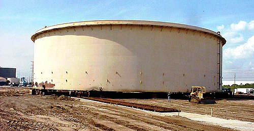
Does anyone know or have experience if using Reach RS receivers on a 2m rover pole and base tripod on top of roof of a very large steel ground storage tank will be a problem?
Thank you!

Please get us photos from this work site!
I think everything should work fine
Just make sure you’ve got good shielding. I have used a 2 by 2-foot piece of plywood and some aluminum foil in the past when attaching two metal buildings.

Something like this.
I am not attaching a Reach RS unit to it, but typical BASE / ROVER use by placing a TRIPOD with a Reach RS BASE on it about 2m above the steel tank surface. Then using a second RS as a ROVER on a 2m rover pole.
Would the large steel area create any Multipath problems, help it or hinder it? I’d obviously have great clear sky view.
Thank you for the help!
I would be worried more about electromagnetic interference. Take a compass.
In my (somewhat limited) experience, you will absolutely see multipath issue here, also from the other tanks/containers/things with black gold in it. However, with your otherwise ok sky view and precise orbits, you could get a decent solution. But RTK I wouldn’t trust, and to get the precise final orbits you will have to wait at least a week.
You are approaching total station territory, I’d say!  and take it from something that have realized that the hard way
I am probably the only one that has ever had to this, so here is another question:
Has anyone used the Emlid Reach RS receivers (both as BASE and a ROVER) on a large metal surface? So not necessarily the ground storage tank examples above, but somewhere metallic very large in area other than the typical such as land or even water? Seems water may have somewhat similar multipath problems also versus your typical use on land? Wonder how working on large steel bridges affect things? Could you lay out stripes on the steel deck of an aircraft carrier without problem?
I may have to test this locally before traveling to this either way.
Thanks everyone for the help in this not so typical area.
I hear ya Wiz! But I need to see if the Emlids will do the job sufficiently before I hock my arm and a leg for a robotic total station. I’d love to get one though!
Totally have grain silos everywhere here. Walking through and your compass moves abnormally from your gait and I wouldn’t do it without a good base plane.
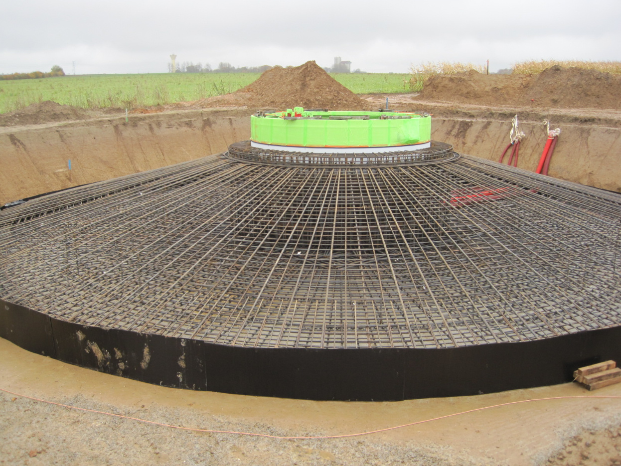
I know this is Trimble, but either way, I see this fellow is working on steel decking (or is this concrete?)with lots of steel rebar etc to boot) very similar what I need to do. I do NOT need to do work on the ground between the steel tanks… that may pose a problem obviously reducing sky view.
Either way, I may have to test locally to make sure. I am hoping @dmitriy.ershov is right. : )
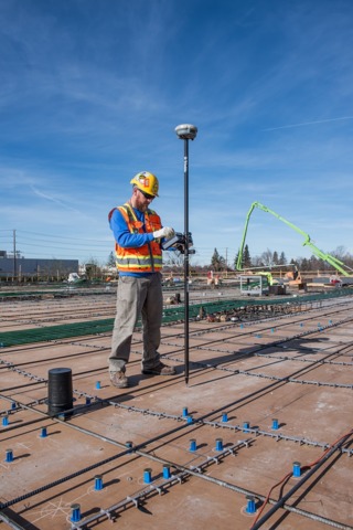
I would expect those receivers to work, but only one way to tell. We survey around huge amounts of rebar all the time. It all depends on how magnetized it is and usually coincides with HV power lines. Here’s a form for a wind turbine foundation in west Texas. Nothing out there, but good luck using GPS…
do you think the photos above your post (Would this present Multipath problems? - #10 by timd1971)
are of concrete and not steel plates? After looking at it more, I think it’s concrete. I figure since you are in construction you may know. What are those blue things and those rails for? I guess they drill into the concrete to place those. The red dirt made me think it was rust? : /
To me it looks like a metal deck that they are about to pour concrete on. Those may be some kind of anchor bolts or receivers.
I concur. The grey thing that looks like a caterpillar is just a support and probably plastic or pot metal. It supports the rebar so that it hovers at middle depth in the concrete slab. The blue things with metal caps are tubes which are pathways for electrical cable, plumbing pipe, etc. After the concrete has hardened, you puncture/remove the metal cap when it is time to pass the wire or pipe through it. The whole orangy-brown base is some kind of suraced boarding or plywood that will give the poured concrete a smooth, even finish. Below is another floor of the building with scaffold-type supports that will be removed after the concrete has hardened.
Thank you bide. Even though I was “hoping” this was steel sheeting (but didn’t see any weld seams), I took a second thought that it was probably smooth concrete as you say with rebar suspended in the middle of, to be poured, concrete with embedded conduits.
O well… wishful thinking I guess. : /
What I need to use the EMLIDS for isn’t typical, so when I get time, I’ll just have to see if a local water dept or refinery will let me test on the steel roofs of a ground storage tank. I’ve worked in these areas so I may be able to talk them into it ($).
I honestly don’t think it will be a problem, but I’d hate to fly to the Mountain Time Zone for the large project and the GNSS method not work at all or give me too much trouble. Yes, Robotic Total Station is ideal, but I just don’t have the time to learn that machine right now. Not that I couldn’t, but I have too much to do right now and also don’t have the time to research a good deal on a robo TS. Personally I’d rather get a Leica Disto 3D or the like.
I am not familiar with surveying on the mother of all ground planes like you show above, but I suspect Glonass would receive the best of any constellation!.
So, if you were on the roof with the rover on a pole and its antenna has no direct view of the metal surface, then I don’t think you would experience any reflective multipath. But if you were close beside the tank or even at the top edge with metal roof that extends up above your rover height, then certainly yes.
And what @michaelL is referring to is magnetic electromagnetic effects on GNSS reception, which is an interesting topic, but I don’t have any knowledge in that department.
edit: clarification
Thank you bide, that is also what I am thinking for the most part and exactly what I need to do… but really won’t know in this case until I do it as @michaelL mentioned. ; )
I think you need to clear your schedule and get that robotic total station and 2 FPV drones with prisms mounted under and on top. Land on each of your points. No helicopter rental or excessive stair climbing required
…or just do photogrammetry.
I should have more specifically said electromagnetic as with the HV lines. There have been a few papers studying the relationship between electromagnetic interference and GPS, but I am not that guy so I just have to base off of practical use. We just erected concrete tilt-wall panels on a church job we are doing that are on the other side of the site from our base station and there are HV lines just behind them and our reception distance went from 2.5 miles to 1,000ft.
If you every get near them make sure you are grounded! If you have every used a metal rod near anything like this you might have experienced that micro-vibration between you and the rod. Not comfortable.
![]() timd1971
timd1971
January 22
You seem to be extremely knowledgable about all of this. If you do not mind, could you take a look at my question?
First of all. I am not " extremely knowledgeable about all of this". ![]()
From my experience, one should expect errors for the points on the ground due to the multipath within a few meters from the vertical walls of the tanks. They can be removed later during preprocessing and postprocessing but using more professional software than RTKPOST.
I advise you to measure the same points twice after a break of a few hours.
This tread should be a discussion about the parameters of the antenna, not the receiver. No one mentioned a word about S/N ratio ![]()