Hello Emlid Community! I am struggling to understand the reference system that my elevation data are in once they’re output by Studio. I am using Studio v1.9 to perform PPK on ground control point data collected with my RS+. When I go to enter my GCP data in Pix4Dmatic (where I am processing my drone imagery), I am not sure which option to select for the vertical CRS. I collected the data relative to NAVD88 + GEOID12B, but the output from Studio appears to be ellipsoidal height. I have attached a screenshot of Pix4D’s processing menu. Does “ellipsoidal height over the GRS 1980 ellipsoid” match the format used in the Studio output? Because my corrected datasheet from Studio says “Ellipsoidal height” I am guessing it is no longer relative to NAVD88? I am attempting to upload my raw data and rover/base files but it appears I’m not allowed to as a new user - I am happy to put them in a OneDrive folder if that would be helpful! Thank you for your help!
In Emlid Studio, the resulting file will be on the global coordinate system, and the projection will be excluded. This way, you will need to choose the NAD83(2011) for the horizontal coordinate system and just the ellipsoidal height for the vertical. You can add the geoid from the drop-down list or upload your own geoid. Let me know if you have further questions.
I was using NTRIP - specifically, a nearby station that is part of the Florida Permanent Reference Network. I used that data as my base file in Studio.
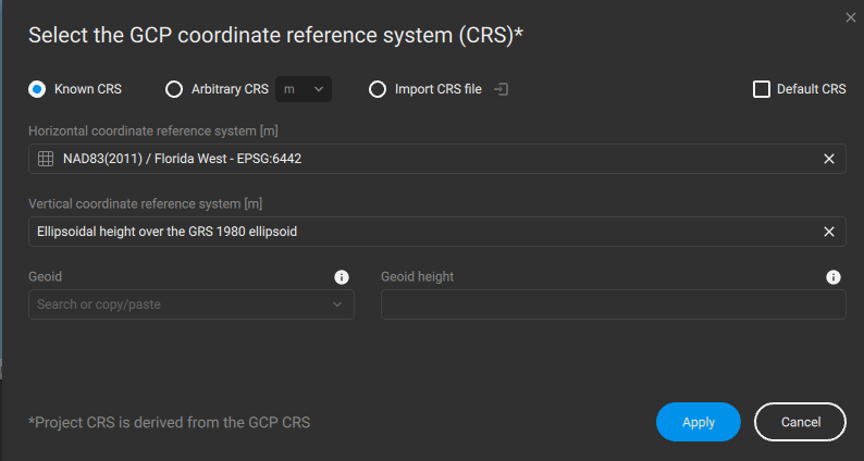
I collected my data in the field with a horizontal CRS of NAD83(2011) - Florida West, and a vertical CRS of NAVD88 - GEOID12B. So in that case when processing in Pix4D I would keep the “Ellipsoidal height over the GRS 1980 ellipsoid” and then choose GEOID12B in the drop down?
@emory.wellman If you’d like to use the local coordinate (Florida West) and the Geoid12B. You can import the resulting CSV from Stop&Go and import it in Emlid Flow with a project in this local coordinate. I share our support tip regarding this:
I am not really sure about the setting in Pix4DMatic, but by doing this procedure, we will ensure that the coordinates in the CSV are aligned with the setting on Pix4DMatic.
Ask your NTRIP provider what Reference System they are aligned to. That should give you the answer. Only if you are working in Single mode (no corrections) will it truly be the Global system.
The NTRIP provider will most likely send out the height in Elipsoidal height, and not apply any Geoid. That is usually done by the receiver through a geotiff (like it is the case with Emlid Flow/Flow 360).
Hi Merryna - I apologize for my delayed response…but that worked perfectly! My data definitely look better when I enter them in Pix4D now. Thank you for your help!