


Today, we’re launching a new series of support tips to help you master the fundamentals of GNSS—RTK and PPK included. Whether you’re new to surveying or looking to refine your knowledge, this series will break down essential concepts in a clear, practical way to prevent errors in your workflow and fine-tune your setup for maximum accuracy in the field.
What is GNSS?
Imagine a fleet of satellites orbiting the Earth, capable of pinpointing your location within meters or even centimeters with the help of additional technologies or services. This is the Global Navigation Satellite System (GNSS). The system consists of satellite constellations belonging to different countries or the European Union and continuously transmitting signals that allow receivers on the ground to calculate their exact position.
The major GNSS constellations include:
- GPS (Global Positioning System), operated by the United States;
- GLONASS (Global Navigation Satellite System), managed by Russia;
- Galileo, the European Union’s satellite navigation system;
- BeiDou, China’s global navigation system;
- QZSS (Quasi-Zenith Satellite System), Japan’s regional satellite navigation system.
*On a side note, the widespread familiarity of “GPS”—the first widely available satellite navigation system and a long-used feature in consumer devices—has led to its name becoming synonymous with the whole global navigation satellite system. In fact, GPS is just one part.
However, that doesn’t mean each system is limited to use in a specific country or region. Combining different satellite constellations enhances positioning precision, provides redundancy in case of signal loss, and ensures better performance in challenging environments.
Why combining GNSS constellations matters
Using multiple GNSS constellations—like GPS, GLONASS, Galileo, and BeiDou—not only improves positioning accuracy and reliability but also helps ensure better coverage depending on your location. Using more than one global navigation satellite system can increase dynamic positioning accuracy and provide independence and redundancy.
Reach receivers support all major GNSS constellations, and it’s generally recommended to keep them all enabled, regardless of where you’re working. While you won’t run into issues by leaving them on, understanding each constellation’s regional strengths can help you optimize performance:
- GPS and GLONASS enhance coverage in northern regions such as Canada, the northern United States, and northern Eurasia. Their satellite orbits are specifically optimized for performance in higher latitudes.
- Galileo is particularly effective in Europe, where its satellites are frequently overhead and more readily supported by local ground infrastructure—delivering strong signal availability and high accuracy.
- BeiDou, while originally focused on China and its neighbors, performs especially well across Southeast Asia, Oceania, and much of the Southern Hemisphere, including Africa and Latin America.
- QZSS is a valuable addition for users in Japan and Australia.
In most cases, using multiple constellations gives your receiver access to 30–40+ satellites, which is beneficial for the resulting receiver’s positioning accuracy.
GNSS segments
Every Global Navigation Satellite System (GNSS) relies on three segments—space, control, and user—that must work perfectly together:
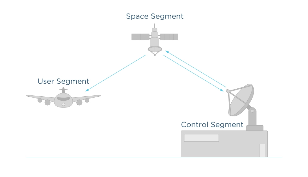
- The space segment, or a specific GNSS constellation, consists of satellites evenly and systematically distributed across orbital planes.
- The ground segment is a network of reference, uplink, and monitor stations responsible for managing the navigation satellite constellation and overseeing its core functions.
- The user segment is a variety of user devices designed to receive and process GNSS signals.
We’re primarily focused on the space and user segments, as these can be directly evaluated and optimized to achieve the best possible surveying results. For simplicity, we’ll assume the ground segment operates flawlessly to keep the space segment running smoothly. So, in the next tip, we’ll begin with the space segment breakdown.