Sorry if this is not the correct spot to post this.
I did some Bathymetric surveying where we used the bluetooth stream output from a RS2 rover with a fix over NTRIP.
I assume that the stream is using WGS84. What is the best way to convert the Lat/Long and ellipsoid elevation to GDA2020 AHD (Ausgeoid2020). It seams a lot of the conversions i have read about only offer accuracy +/- 3m, which seems to defeat the point of using the RS2 with a fixed solution.
The Cors is using GDA2020 (AUSCORS). So are you saying that if the base in using GDA2020, that the lat and long output will be the same? I wasnt sure if RS2 only outputted WGS84, similar to when you set it up as a base, it converts to global coordinates.
Emlid uses the term “Global CS” to define whatever [geographic] datum the base is referencing. If the CORS is in the datum you want to use, then you are good leaving the rover on “Global CS”.
When the RS2 is set up as a base (in SINGLE, without receiving corrections itself) and averages a point, it is only receiving data from the satellites, so WGS84 is used because that is what the sats are using. So in that case “Global CS” in that project would reference WGS84. It is a simple approach, but can be a little confusing at first.
What is the best way to convert the Lat/Long and ellipsoid elevation to GDA2020 AHD (Ausgeoid2020).
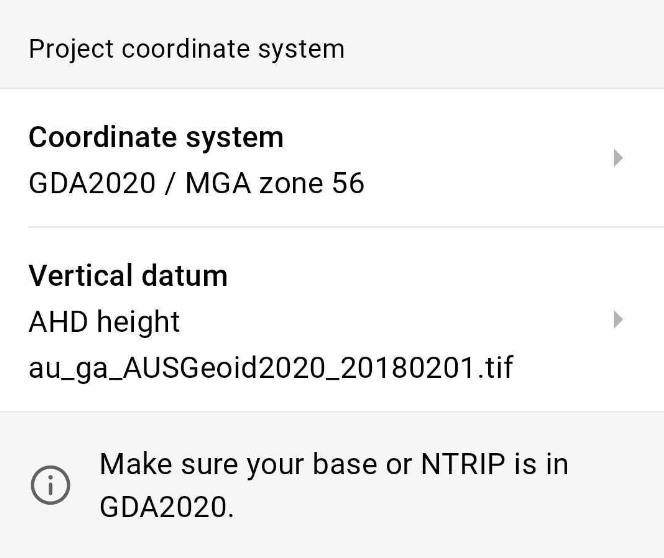
The Global CS option indeed gives you GDA2020 coordinates if the base is in GDA2020. But you’ll get only ellipsoidal heights with Global CS. I’d recommend using a projected coordinate system based on GDA2020 with the AHD height:
You’ll see both projected coordinates and geographic coordinates in GDA2020 for each point. So if you need geographic coordinates, you can still obtain them in this setup.
Thank you for this. However, i am unable to use a projected coordinate system when streaming over Bluetooth, as there is no option for this, correct?
In regards to setting up a RS2 as a base, i understand that it is broadcasting LORA or NTRIP in WGS84 if i use a single point average. However, what if my “base” has a fix from a CORS network to get its location?
However, i am unable to use a projected coordinate system when streaming over Bluetooth, as there is no option for this, correct?
You’re right – the projection is not applied when Reach outputs its position over Bluetooth. But if you receive the Reach position in a 3rd-party app, you can usually choose a desired coordinate system there.
In regards to setting up a RS2 as a base, i understand that it is broadcasting LORA or NTRIP in WGS84 if i use a single point average. However, what if my “base” has a fix from a CORS network to get its location?
When your base gets CORS corrections via NTRIP, you can average its position with a Fix solution. The base will calculate accurate coordinates in the datum of the CORS network. So, points collected with the rover will be tied to the global coordinates.