


I understood. I bent over to know more about Autel, and it seems to me that it will be my next drone. I intend to take it with RTK/PPP. It seems to me that an already integrated drone is more interesting than adaptations. Here (Brazil) there is a lot of marketing for some brands of equipment, such as GNSS, drones… and there is much more around the world. It seems like we’re always behind. But back to talking about the drone, would you recommend the EVO II RTK? Can I get good results with it in RTK and PPK?
1 Like
Hi…
Want to know if autel drone can still taking picture and fly autonomosly follow waypoint even when disconnect with RC
At the time we got ours there was no specific RTK module but we wanted the V2 and the Smart Controller so we got the Enterprise bundle and bought the RTK module separately. I highly recommend the Smart Controller so you should see if it available on the new V2 RTK.
1 Like
Yes, that is one of the parameters to choose from. It can RTH, Hover or Continue on missions but I’ve never tried it on a standard waypoint flight.
1 Like
10 posts were split to a new topic: Working with Phantom 4 Pro
This is absolutely lovely! THANK YOU Emlid! You are taking the GNSS industry by storm. You have a loyal customer in me! This simplifies my workflow immensely. Please stay awesome!
15 Likes
I do see a scenario where it would be nice to share projects with other Emlid cloud users.
E.g with external contractors, operators, some in your own team etc.
6 Likes
100%. We have an account (group) specifically for these kinds of scenarios. We started with drone@***.com so now we have vdc@ for everything GPS and model related. I am sure we will break this out at some point.
Personally I wouldn’t run anything not vetted with a 3rd party app that relies on it.
Are there any plans to have an option like the PC interface on mobile? Navigating a list view that you can one see like the first 10 characters on will not be efficient when we hand these off to the field. Because there isn’t background or linework in Reach Survey we will have to build a separate file for each discipline so that you can actually see what’s on the screen. These are a few of the file names…
22000 Hempfing WW (wastewater)
22000 Hempfing SS (storm sewer)
" W (water)
" E (electrical)
" etc… etc…
If I had to guess each project has about 15 disciplines. I suppose we would need separate logins for Excavation (dirt), Concrete, Utilities and Vertical work.
1 Like
Noted!
1 Like
One thing I failed to mention about the DroneDeploy setup is that in the second picture the top row is “Quick Access” where it pulls up the 5 projects closest to you. Very handy. I think a GPS company could probably do something like that. ![]()
3 Likes
Hi Michael,
I’ll register it as a feature request, but want to make sure I understand you right. Do you mean something like layers for different types of objects?
1 Like
Yes, in a DXF everything is color-coded and has a specific layer name. Even though it may take a while to get line work in that capability, it could also be used for points. We put our points on different layers and specific descriptions. That way we can put points for storm, sewer, sanitary, sewer, water, and other layout items.
1 Like
Yeah, agreed that it’s quite useful. I’ll note your request. Thank you for sharing it!
1 Like
Hello,
An idea came up, maybe it will be useful for other users as well.
In the Web interface and in RV3, in the Emlid Account option, the option to add multiple profiles could be included, similar to what you have in Ntrip profiles.
In my case, I have several pieces of equipment in several companies, and I wouldn’t like to mix the projects between them, so I separate them by different accesses to the Emlid Account. But to make it easier, these access profiles could be saved in the APP.
Another thing I noticed is that every few times the APP asks to validate the access, can this be configured differently?
2 Likes
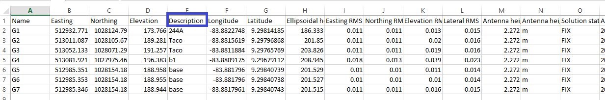
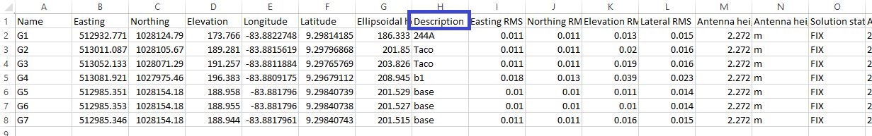
What is the reason that the description field is located in different columns when exporting a project than the RS3 app and the web interface.
2 Likes
Hi Mauricio,
Sorry for the delayed reply.
Thanks for sharing your idea with separate profiles for projects. I’ll pass it to the team for consideration.
Sorry, I’m not sure that I fully get it. What validation you mean?
1 Like
Hi @JAGUERO,
Hmm, interesting. Let me check it with our devs. I’ll get back to you once I do that.
1 Like
Hi @JAGUERO,
ReachView 3 and the Web interface use geodata a little differently. That’s why CSV files from them have this difference in structure.
However, it shouldn’t cause any compatibility issues. Web interface, ReachView 3, or Emlid Studio should accept both files. If something comes up, please let us know. And thank you for bringing this question up!
2 Likes
Thanks for the reply
3 Likes