


Hi all. I have a Emlid RS2 using RTK and have been conducting a test comparison betwen the data from my Aeropoints and thre recorded location using my emlid. Each time the vertical is about 2 mtrs different.
I know the aeropints are set to ODN Height, how do i find out what the Vertical Datum used by my RS2 is
If you’ve used EmlidFlow to record your test points, then the point heights are in whatever CRS you’ve set when creating the flow project. If you haven’t set any CRS, then it’s likely it’s based on Global or WGS84 with an ellipsoidal height.
If you open the EmlidFlow Project and examine the project settings, it will tell you what CRS was in use under ‘Coordinate System’. If it says GlobalCS, then you have used the default CRS without defining a specific height Datum.
I’m presuming you’re based in the UK from your reference to ODN? To convert your point data to OSGB36 & ODN, first export the point data from your existing Emlid Flow project. Then create a new Emlid Flow Project with the CRS set to OSGB36 with ODN as the height (allow it to download the CRS definition files if it asks for them). Then, using the exported data file, import your point data into the new EmlidFlow project. It should automatically convert the positions and heights from global/WGS84 across to OSGB+ODN. Finally, you can re-export your point data from the new project and it should now be in the right system for you. Hopefully location and height will be much closer now.
You can also do the same conversion using the online version of EmlidFlow360.
Hope that helps.
Hi @sgeyeuk,
Can you please send me the two datasets that you compared? I’ll check them to see what may cause the difference between the coordinates.
How do i send you the files?
Millhead, England (3).zip (1.5 KB)
They’re around 2-3cm different, not 2m.
| Aeropoint | Reach | Aeropoint | Reach | |||
|---|---|---|---|---|---|---|
| Point number | Ellipsoid height (ETRS89) | Ellipsoidal height | Orthometric height (m) | Elevation (m) | difference (m) | |
| — | — | — | — | — | — | — |
| 1 | 67.918 | 67.954 | 15.721 | 15.757 | 0.036 | |
| 2 | 67.615 | 67.641 | 15.42 | 15.446 | 0.026 | |
| 3 | 66.994 | 67.017 | 14.798 | 14.821 | 0.023 | |
| 4 | 65.913 | 65.934 | 13.718 | 13.739 | 0.021 | |
| 5 | 63.884 | 63.909 | 11.687 | 11.712 | 0.025 |
Did you use the same NTRIP correction service for the Aeropoints and for the Reach?
(ps, used to visit Steamtown when I was a kid!)
No the areopoints are corrected when the data uploads through my phone to there server. Sorry if I’ve mis read the data
I’ve checked your data and also saw a difference of only a few centimetres between the elevations. I’d consider these coordinates acceptable for an RTK survey.
1 Like
I think they’re in the same ball-park, at least as much as can be expected if they’re not using the same correction service. If you’ve recorded the RS rover log files, then you might get them to agree a bit more by doing some post processing in Emlid Studio against the OSNet CORS Rinex logs for the same time period, but I’m not sure it’d be that much better.
If you want to try, then download the OSNet log for your nearest CORS base (one of Shap/Giggleswick/Blackpool) for the time period you took the measurements (remember they’re in GMT+00 time). Then use EmlidStudio to run Stop & Go processing. OSNet rinex goes to the base, reach logs (.2xO & .2xP) to the rover & navigation, and Emlid Flow export to the Emlid Flow Project input. Use the ECEF location of the OSNet station for the base location (OS have a file on the ftp site with the positions in it) in preference to the Rinex header position.
Hope that helps.
Thanks but if your happy then so am I. I will keep and eye on it. Thank you for your help.
1 Like
Hi Nick , sorry to be a pain but I have had a look at the CSV file from Millhead and Carnforth that i sent you in the zip file. I’m not sure were you got the few centimetres difference but that is not what I’m seeing.
To recap. both file are from the same site and recording the same points.
Carnforth was recorded by my emlid reach RS2 and Millhead was recorded by the aeropoints.
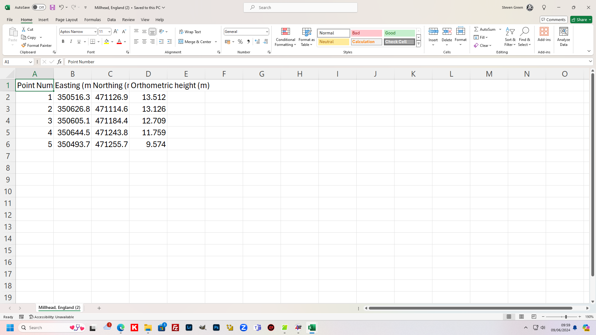
This image is from the Millhead CSV
And this image is from the Carnforth CSV.
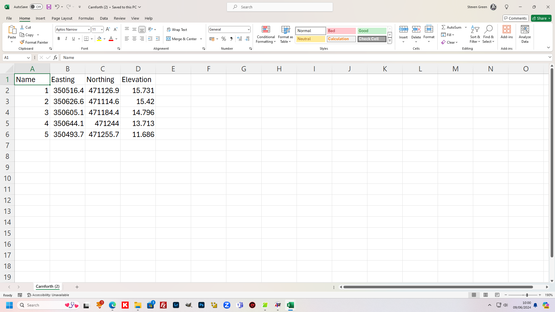
As you can see the Elevation is around 2mteres difference.
Please let me know what you find.
Are you using the same files? 'm not sure what’s happening as when I open your Millhead(3).csv in Excel, I get the following figures:
| Point number | Latitude (ETRS89) | Longitude (ETRS89) | Ellipsoid height (ETRS89) | Easting | Northing | Orthometric height |
|---|---|---|---|---|---|---|
| 1 | 54.13360224 | -2.75880972 | 67.918 | 350516.38 | 471126.866 | 15.721 |
| 2 | 54.13350297 | -2.7571207 | 67.615 | 350626.623 | 471114.636 | 15.42 |
| 3 | 54.13412783 | -2.7574612 | 66.994 | 350605.119 | 471184.398 | 14.798 |
| 4 | 54.13466709 | -2.75687435 | 65.913 | 350644.106 | 471243.987 | 13.718 |
| 5 | 54.13475807 | -2.75917715 | 63.884 | 350493.753 | 471255.724 | 11.687 |
The figures from Carnforth(2) give:
| Name | Easting | Northing | Elevation | Longitude | Latitude | Ellipsoidal height |
|---|---|---|---|---|---|---|
| 1 | 350516.375 | 471126.89 | 15.757 | -2.75880982 | 54.13360245 | 67.954 |
| 2 | 350626.623 | 471114.636 | 15.446 | -2.75712071 | 54.13350296 | 67.641 |
| 3 | 350605.116 | 471184.423 | 14.822 | -2.75746126 | 54.13412804 | 67.017 |
| 4 | 350644.114 | 471244.006 | 13.739 | -2.75687425 | 54.13466725 | 65.934 |
| 5 | 350493.742 | 471255.741 | 11.712 | -2.75917733 | 54.1347582 | 63.909 |
That’s in the order of 2-3cm difference in both the ellipsoidal height figures, and in the Orthometric/Elevation figures. I’ve not done anything to the figures from your csv’s other than to open them, and then remove blank or non-relevant columns. The fact that the ellipsoidal heights (as well as the x/y Northing/Easting figures) are agreeing (within reason) says the measurements aren’t the problem…
Are you running some processing on the csv’s to get the figures that’re in your screen captures? The elevation figures for both lots of csv’s differ from the ones you posted in the images above. At a hunch I’d say it looks like you’re applying the OSTN15/ODN projection to the Millhead figures a second time somehow. (ed. it’s not that. I’ve just tried plugging the Ortho height into OSTN15 as an ellipsoid height & that gives a much bigger difference -ve height in fact)
1 Like
I’m not sure what’s going on I have re done the download and from my Emlid reach app and and aeropoints and zipped them again.
Millhead, England (2).zip (540 Bytes)
Ill get onto Propeller (aeropoints) to ask them and I have looked in to a couple of others and have found that when i download the CSV file now some of the results are different to the CSV file from when i originally downloaded it.
Not sure what’s going on
Your files seem to be getting muddled or edited in some way. I think you need to go back to the original files & check you’re getting the right ones - the first zip files you posted had a lot more info in them. I’m guessing the files in your second zip file have been edited in some form - in the case of the Carnforth one, it’s not the direct export from the Emlid Flow program (it contains a lot more columns) and the point elevations are fractionally different.
Go back to the original source files, ie from your EmlidFlow project and also redownload the ones from Propellor and see what you get from them - post them both back here as they arrived in their respective exports/downloads, don’t import or open them in Excel & resave them.
Hi @sgeyeuk,
Hmm, interesting. Can you please export your project from Emlid Flow and Emlid Flow 360 and share both files without editing them? I’ll check the coordinates again.
This topic was automatically closed 100 days after the last reply. New replies are no longer allowed.