Hello,
I am looking for a solution to record coordinates of underground utility locates. We are not a survey shop, so our surveying experience is limited.
We have a project where we may need pick up coordinates a couple of days a week, for about a year, after than the EMLID will have occasional use.
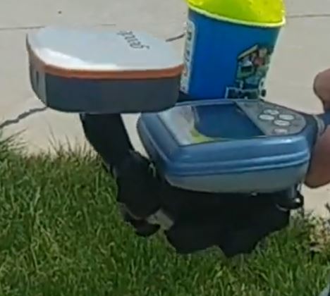
In talking to a local locator, he mentioned using EMLID which allows him to record X,Y,Z for the underground utility. I do not know what setup he has, but I imagine the Emlid receiver sends the data via Bluetooth to the locator (such as RD8100 Radiodetection unit)
What would you recommend? I understand that Reach M2 and RS2 work the same, so when is the RS2 better than the M2?
I am thinking of a compact setup, with M2 for base station and the M+ strapped to the locating tool, so weight is minimized.
If I were to use only an M2 on the locating tool, with no base, what accuracy should I expect?
I know by myself that locating underground utilities can sometimes be a challenging and time-consuming process. I’ll describe some features of our products and answer your questions down below.
Multi-band vs. single-band
As you’re surveying utilities, I guess that you’re generally working in urban areas. In such an environment, a multi-band Reach RS2 or Reach M2 will be the optimal choice for you. They can get a fixed solution in partially blocked sky conditions and on baselines up to 60 km in RTK and 100 km in PPK.
Single-band receivers need a clear sky view and can get fix on baselines up to 10 km in RTK and 30 km in PPK accordingly.
To learn more about the differences between single-band and multi-band receivers, you can check the special guide in our docs.
Reach M2 vs. Reach RS2
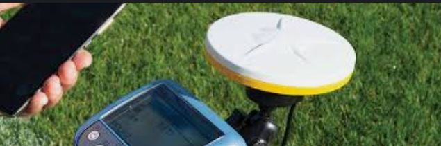
Our Reach M2 is generally designed for integration with other hardware. It is small and has many ports required for integration. It should be connected to an external power source and GNSS antenna. It doesn’t have dust and water protection.
Reach RS2 is a field-ready solution. It’s durable and protected from water and dust. It has an integrated GNSS antenna and battery. The receiver can hold up the charge up to 16 hours in RTK mode with a cellular module enabled.
Positioning accuracy of a standalone receiver
A standalone receiver provides positioning of a few meters of accuracy. If you need a centimeter-accurate positioning, you should use the second receiver as a base. As an alternative, you can connect your receiver to an NTRIP service.
Position streaming
Reach devices can output their position via Bluetooth or Serial port in industry-standard NMEA 0183 format. You can check if your RD device can input position stream from an external GNSS receiver. You can find a full description of this feature in the position streaming guide in our docs.
I do what you describe and 2 RS2 units is what I use. I am often in hilly wooded areas with powerlines running above me in the RW. This often poses problems with getting a fixed position. When I’m in better surroundings the setup works quite well. Semi trucks constantly driving by can cause you to lose your fix as well. The other challenge you will have is finding the correct position of your base unit. I typically am working on DOT projects and can find survey control pins so I can correct everything in CAD after the fact. If you can’t find control points the process becomes more involved using post processing.
All in all it sounds like a simple exercise but you will have days that you’re frustrated in the field.
Thanks for the feedback. How is your process set up? Do you do one pass to locate, then a second pass with the RS2 on a rod?
As part of the locates pickup, the operator needs to perform other tasks along the way, such as record asset types, open panels or pull boxes, take notes, photos.
I will be subscribing to an RTK network, such as SmartNet or CanNet, in order to eliminate the need for a base.
I would really like to use an RS2 attached to the locating tool, but it will add 1kg. Not excessive, but the operator will carry a tablet, some tools, so really want to minimize weight and amount of equipment.
If I could make to with M2, (with the GNSS antenna, in a custom enclosure, and using a USB power bank) that would be great.
Thanks.
The locating tool can receive coordinates from an external GPS receiver.
In order to minimize weight of equipment, I am still considering to use:
M2 with the GNSS antenna, powered from a USB power bank. It will be custom enclosure, one tells me it can be built with a 3D printer.
RTK network subscription
Do you see any issues with it that would prevent it from working as intended?
Can the M2 unit be connected to the ReachView 3 app the same was as the RS2 does? I assume the M2 will get its VRS corrections by accessing the internet via the cellphone running the ReachView app.
@Napocensis
In my situation I’m only gathering precise data for a small area of assets, generally for coordination and relocation due to road construction projects. I work alongside another individual doing the actual locating work so I’m focused on my tasks and he works on his. I do use my unit on a rod and I also use a program called Locus GIS on an android tablet. This requires setting up a Bluetooth connection between the Rover and the tablet.
Yes, Reach M2 can be connected to the phone’s hotspot the same way as Reach RS2.
However, I recommend you to look for the Reach RS2 for your application. It’s a ready-for-field solution — no need to worry about 3d printed custom cases or wiring for the Reach M2 setup.
Moreover, you can face environmental conditions when the receiver should be raised from the usual height of RD8100 to get fix solution. In such a case, you can easily place Reach RS2 on the survey pole comparing to M2. Reach RS2 will be easier to handle in your type of survey.