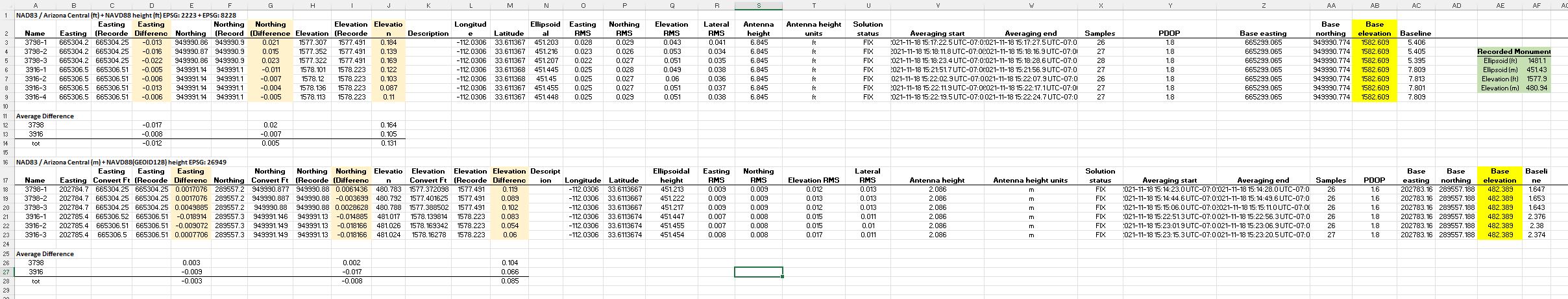
What does “Base Elevation” represent in the survey project export? Please see image of export.
The image shows the export file of two projects combined. The setup was Base/Rover, manual over known monument. All the survey points collected check-in with high accuracy. But the column titled “Base Elevation” identifies elevations that do not coincide with the known monument ellipsoid or elevation.
Can anyone please educate me, what does “Base Elevation” represent?
Hi
I see you have added features to your excel but in my “stock” csv output from the RV3 (Reachview 3 app), the elevation (stock coloum nr 4) is a product of my setup (Survey configuration in the Reachview app).
If I set it up correct with true elevation model(in my area that is NN2000 elevation model), the “elevation” section is the true ortho height in the terrain and base elevation is the true ortho elevation of the base
Or to give an another example. If no elevation model was selected in the app and you did not set any distance to ground from unit( bottom of base/rover). The elevation you would see in the elevation column and base elevation, is the ellipsoid height. The elevated distance your unit (base or rover) are from the ellipsoid. It could be negative or positive.
The base coordinates in the CSV file show the position of your base station antenna. Coordinate system and units of measure for them are the same as you have chosen for the project in ReachView 3.
So for the first dataset, the base height is in NAVD88 in feet, while for the second one, it is in NAVD88 (GEOID 12B) in meters.