


Hi.
I am using two Reach RS+ units as base and rover. Both units are up to date with current firmware.
After a few initial difficulties getting accurate results from converting survey data to useable uk coordinates, the new ReachView3 app has eliminated any problems I had.
After a brief test survey with the app and download to QGIS and then an export to CAD I was really happy that the data stayed consistent. By that I mean, the dimensions I measured in QGIS matched the exported data into CAD and all this almost tied into the taped measurements I took on the ground.
Errors varied from 3mm to 47mm when checked against the taped measurements on the ground which considering it was in my garden with a few trees around, I was really pleased with.
I should add that this was all done by me just setting up on the lawn and letting the base gather it’s own home point and not with me inputting any known coordinates so I realise while it’s pretty accurate to within itself I haven’t checked it against actual O.S./GIS map location data yet.
My next task is to set the units up for corrections over NTRIP so I was hoping there were some uk users who could recommend who they use for this and if you’re accessing a paid or free service?
Any help you could give for setting up with a service would be gratefully appreciated thank you.
Michael.
Thank you Seth.
I class myself as a hobbyist really doing gps work in my spare time so I can’t really justify the £77 a month fee.
I believe there is a per day fee you can pay.
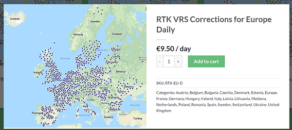
Ah great I looked for something like that for uk but it didn’t show up.
Weird how you get full Europe though.
Thanks again.
And thank you for the help you’ve given on FB lately.
Can you send me the link please to the Europe one. Doesn’t seem to show up for me in the uk.
Yes I can get to that point but for uk specific corrections there isn’t a per day subscription.
Only monthly or yearly.
Hello Michael,
I hope you are fine!
In your place I would start to determine the coordinates of a base that I would create in my garden or on my terrace by using the nearest permanent GNSS base for example in your case.
So I would let one of my receivers do a two hour observation for example if you are lucky you can get the fix solution with post processing using RTKLIB or other downloading the RINEX file which will normally be available the next day on EUREF.
The base closest to you on EUREF (DARE00GBR) :
From this base I would do all the RTK survey work within a radius of 10 km if not static less than 20 or 25 km.
my RTK I would do it with the NTRIP option if the GSM network is available with rtk2go for example if not in PPK.
This topic was automatically closed 100 days after the last reply. New replies are no longer allowed.