UK GCP capture workflow with RS2+ & PPK solution help

Good Afternoon.

New to the Emlid Reach RS2+ world here and struggling with our ground control point workflow with PPK solution using OS RINEX data as we only have one receiver…however we’re struggling to obtain a fixed solution. Looking for some help/advise please.

Currently we are setting up over an unknown control point, powering on the unit, waiting a few minutes before starting a log file, conducting a 5-minute base configuration, then recording a point in Emlid Flow with SINGLE averaged observations over a 45 minute period. Wait another couple of minutes and then ending the log. All within an hour so we can utilise 1 hr RINEX file from the OS during processing. Move to new GCP, rinse and repeat. All GCP locations are in good positions and free of any obstructions.

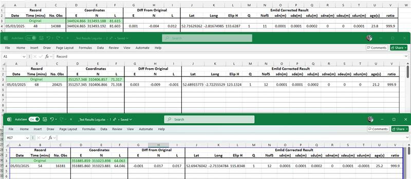
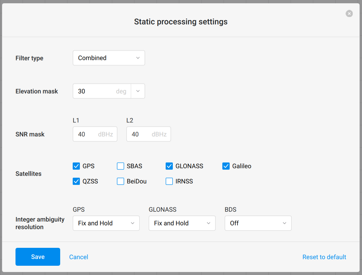
Log files are downloaded along with the CSV file for the recorded points and run through Emlid Studio 1.9 via stop & go. Use Observation & position files from the receiver and the RINEX from the OS to generate new position file with the default settings other than a combined filter type. However we never get a solution so have to run either forward or reverse and then only a SINGLE solutions to the tracked positions is found, then run against the CSV returns SINGLE solutions for the recorded point(s).

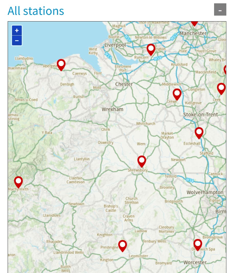
The OS base we are using is in Shrewsbury (SHRE) and is never more than 40km away from anywhere we will be operating.

Help…

Sounds like you’re doing a couple of things wrong and using the wrong processing.

If you’re “averaging” each position for 45mins, then you don’t need to do the initial “Single” averaging for 5 minutes as it’s irrelevant (it does seem to let the RS unit “settle” though).

Simply set up the RS on the GCP, turn it on and start the logging. When you’ve been on point for your chosen time, then record your EmlidFlow point (Not needed, but take only as a backup), stop the logging and move to the next point and repeat.

When you’ve done all the GCP positions, then go back to the office and download all the logs, download the OS RINEX files and then process each separate GCP log point using the Static workflow instead of the Stop & Go.

You’ll need to process each individual log file along with the matching OSNet RINEX log separately. OSNet RINEX is used for the BASE data, with the Reach RS .25O in the Static Receiver and the corresponding .25P as the Navigation file. Then you can run the processing with default settings, although I’d run a Combined (Fwd & Back) solution. You can most likely disable the SBAS option too. Sometimes turning off the BeiDou processing can give a better result here in the UK too.

By the way, you don’t need worry about keeping everything inside the 1hr “window” of the OSNet RINEX file (actually a 90min log). EmlidStudio can use multiple Base RINEX files - instead of dragging & dropping a single file onto the region in EmlidStudio, click on the BASE region to bring up the file window, then add mutliple RINEX files before clicking “Open”.

Rinse & Repeat for each GCP Location and log file you recorded.

The Stop & Go Processing is more appropriate for when you use the RS unit with an external correction source - either another Reach Unit, or a 3rd party NTRIP provider.

You don’t need the EmlidFlow point data CSV - when using the STATIC processing the accurate point position is coming from processing the Reach’s log file, not the EmlidFlow point that you record.

I hope you don’t have a lot of GCP’s t do as that’ll take you a fair number of hours! You might want to think about finding an NTRIP correction source - either another Reach RS running as a Stationary Local Base & sending Local NTRIP, or a 3rd party NTRIP source. First way involves shelling out for another unit, second way involved coughing up for a subscription (the free NTRIP streams aren’t reliable enough).

Hope that lot helps…

2 Likes

Hi @PSGSurvey,

Thanks for sharing your workflow in detail!

Could you share your RS2+ and OSnet logs with me? I’d like to take a closer look and see why the solution isn’t getting a FIX. You can either PM me or email them to support@emlid.com.

It seems like you’re on the right track with your workflow. However, just a couple of suggestions:

  • Using a PPK workflow, you don’t need to average the base position. You can start logging right away.

  • Since you’re working with multiple GCPs, processing each separately with static processing can be pretty time-consuming. I’d suggest using the Stop&Go workflow instead.

Start recording a raw data log and collect all the points in the Emlid Flow project. After that, post-process the logs and CSV file in Emlid Studio. You can use the OSnet log as your base, but make sure the log durations align. This way, you’ll get your corrected CSV. You can find more details on how to set it up in this guide.

As @ElectroNick suggested, if you’re looking for real-time results, the NTRIP service would be an alternative.

2 Likes

I agree with Nick and Inkar for the overall workflow. No real need to use the stop and go for what you are doing and the initial static log single average isn’t needed.

Out of interest how long is each log for your GCP, is it 45 minutes in total or does the whole process including averaging take 45 minutes? I might be reading things incorrectly but just to be sure how much data you are working with. Also logging rate, are you running more than every 30 secs, say 5 secs or 1hz? It will give more data to work with if you need to run in a different software.

But more generally. 40km is a huge baseline to be running as a single vector. Even a “fix” on that will be shaky and lower confidence. One of the issues we have with OS is the parsing of data to 30 secs so any static log needs to be longer, at least 1 hour. As Nick says, studio can take a series of OS files and run through them in sequence, so give yourself more time for that static logging to increase the confidence. But again 40km is too long for the single baseline. Running it through multiple baselines and getting a proper adjustment would work but that involves paid software or clunky academic tools and manual labour. Having another unit close to site is the best option, it can sit logging for as long as you are there working, and provide PPK to your drone if there is an RTK module on board. Then you can run stop and go PPK for GCPs after processing your base to gain the final position for that. NTRIP options are expensive and a good service with VRS (calculated virtual station as close to your location) is advisable.

We are limited here in the UK with places to process data. The freely available NTRIP seem to be dodgy, with no guarantee what they are providing, and paid NTRIP is scandalous money if you are a small business or occasional user. Ideally OS would provide high rate data and a PPP service so there is at least some central coordination of data and everyone can work to the same system. It’s a wild west currently and people can essentially provide results with no checks for how they get there. The feedback I had from OS was the data was too commercially valuable to let the great unwashed have access and a proposed free EU wide RTK and PPK (20cm accuracy) would suit the needs of some. It’s a shame as OPUS, NRCAN and AUSPOS with the respective geodetic services offer very good tools and guiding minds to their areas.

Hopefully you get a solution, but add more info here, such as settings etc and more advice may come forward if people can see what you are seeing on screen. I would send the data to support as they are good at helping out with issues.

2 Likes

Thanks all for your input so far, especially @ElectroNick as I know they have helped me out previously too…I have obviously not followed instructions quite right.

@inkar.madikyzy - I’ll fire over the files now for you to take a look at.

@scottmitchell63 - 40km was the furthest we are likely to be from our nearest OS Base. We only have the one receiver so can’t use a local base. Don’t trust the NTRIP data either. The only option we have left is using the OS base nearest us in Shrewsbury. For the data I’m working with in Oswestry, the baseline is approx 26km. Appreciate this is probably still not great but the next nearest OS Base is miles away.

I’m now weighing up a corrections service so any suggestions on what people have had the most confidence in using would be good. Approx pricing etc. or point me to a website and i’ll do the digging.

Thanks again in advance for any further assistance.

You need to buy another receiver and make your own base station and use Emlids caster. Of course you would need to compute this base position and orient to your country’ s datum. This would be the easiest solution unless you can verify the existing RTN with local passive control marks to truly know what system they are using. Plus you’ll have way shorter baselines.

1 Like

Can’t help with the VRS/NTRIP service I’m afraid - in a lot of areas I’m working, I can’t get Cell signal, so I’ve ended up buying a 2nd RS3. It has made the whole workflow a lot more streamlined and easier than trying to do everything with a single unit. Plus it helps ensure I’ve got at least a good relative/local accuracy - working up in the remoter parts of the North Pennines & Northumberland some of my baselines to the CORS are pretty long too.

Hope you get some ideas with the RTK/Ntrip provider.

I’ve also got to agree with Scott about smaller users in the UK being stuffed by the OS and it’s attitude to ‘commercial’. Still, we should be grateful for the small sops they do allow us :roll_eyes:

Yeah you are in a blind spot there. I’m in the Highlands so know all about that.

Nick and Bryan are right, the best method is to have that local base unit, keep the worksite as tight as possible. I know its an extra expense but in the grand scheme you will likely need to weigh up the cost of the 2nd unit versus NTRIP and the hassle when phone signal is rubbish. As Nick said, the pitfalls of the OS net are frustrating and unfortunately the NTRIP is not a watertight solution and we are left hanging in the UK. Nick was less diplomatic in person about it all I have to say.

In terms of options you have:
Leica (Hexagon) Smartnet
Trimble RTX
Trimble VRS Now
RTK Premium Network Solutions by Premium Positioning

I’ve not got much details on them as I’m generally working in ITRF rather than ETRS89 so they are not compatible for the job. So make sure you know what you are getting and what you need. I’m assuming you are in OSGB36 most of the time anyway? If so, they should be fine for the ETRS89 based stream. Ask what they are providing and check that against the OS coordinate systems handbook on their website. That’s a great resource anyway to have for reference. Also the PPP sites will not give you the ETRS89 result you need. Trimble RTX post processing does have an ETRS89 selection but with emlids you can’t use it. Between a rock and a hard place at times.

There are a few places that will flog NTRIP to you, any of the survey resellers like G2, Sunbelt, hexagon (Zenith I think they go by down South) and the premium positioning one is from coptrz and heliguy. Costs, smartnet is about 1500 for a limited subscription, 2000 open per year and I’d imagine the others will be in the same ball park but may have better limited access deals. As I said before, having a VRS type NTRIP is a good option as it creates the virtual station at the worksite, where you may still be latching to the nearest CORS base on the basic NTRIP RTK (Shrewsbury again).

When you weigh up that price against another unit and maybe some good software then you have bit more power in your own hands. It may seem like overkill with equipment, but surveyors have a doomsday mentality and want to plan for the worst of all scenarios.

2 Likes

:rofl:

In fairness, individuals within the OS have always been really helpful and great to work with whenever I’ve dealt with them directly.

Thanks @scottmitchell63, that’s a really insightful post.

Excuse me if i’m not following but surely buying a 2nd receiver is a no brainer then as 18months of paying subscription costs would be more expensive than an additional unit anyway? And the likelihood of my projects being in places unreachable of cellular coverage are slim. Or will I still need some sort of corrections even with 2 units operating as base & rover?

Yup, That was my 2nd biggest reason for going with 2 units - plus I hate subscriptions.

Sure, there are times when just turning up and having a single unit with external ntrip subscription would be easier, but once you get into the swing of using your own base-rover setup it’s a definite no-brainer.

2 Likes

My thoughts exactly.

Guess I need to write another business case to spend some more money :see_no_evil:

1 Like

If nothing else get an M2, good NGS quality antenna ( they are pretty reasonable) and a good power bank.

I use mine as static all the time as a receiver onsite even if I’m using RTN . As @scottmitchell63 said, I’m always prepared for post processing. I try not to depend on any one method. I’d like to have at least 2 methods for verification and in case of lost cellular.

3 Likes

No worries, glad it was helpful.

They are all options and opinions, but finding what is best for you is the main thing to consider. Get that workflow down, as Brian and Nick have said. Be happy with what you are doing and know where things can fall over and plan for it. The easiest is always log data, even on NTRIP. If things go South you can always rely on the high rate log file as raw.

Ideally you could get a NTRIP stream and that would be you, no additional work, the export file is your GCP file. Unfortunately that is either expensive or comes with risk of no access or low quality in the field etc. I would ask around the providers and see what they can do. There was one (maybe the original premium positioning mob) that offered a pay as you go model. That would have been great as you can use it only when needed. There may be a case for using this.

Local base always works. It is a short baseline, you can control the rate of output to the rover, you have the base and rover logs plus stop and go type data to PPK. Again have a look around, Bryan suggests the M2, and there are others that have been mentioned on the forum as cheaper alternatives to the cheaper alternative of a RS.

The downside is getting your base resolved to the correct datum. Using the OSNet and studio is a good option, and with a static log you can push the time out to increase the confidence. Consider what the tolerances of the job are. How much slack do you have in the error budget and what do you have to provide as proof in the final handover pack?

You can also combine the two. Use the NTRIP to get an average fix on the base, then set that broadcasting to the rover. Or for sites with return visits set benchmarks and check shots the first time and use one as the base for subsequent visits. Stick a nail in the ground or ask to get a 5/8 bolt planted somewhere with good access. The additional shots are a sanity check and proof of your results. Essentially stake out a check shot and see the difference, book it and report it if needed. That way you can use the NTRIP the first time and then save on the credits or tokens depending on the subs model.

5 Likes

Hi everyone,

Circling back with an update. We took a closer look over PM and found that the issue was a time mismatch between the RS2+ and the CORS logs. So, Emlid Studio can’t overlap the data, resulting in only a Single solution.

Thanks for taking the time to share your thoughts!

1 Like

Good Morning Inkar

So after some trial and error testing, we’ve finally landed on a solution thanks to the very helpful @ElectroNick

Not only was there a timestamp issue with the incorrect CORS logs being downloaded, we weren’t quite using the correct filters to mask the unwanted signals either.

We’ve now re run hour long obs against known points captured by 3rd parties, using alternative equipment with subscription corrections, and got within acceptable tolerances to their data.

So a combination of workflow error, human error and correction error has attributed to our struggles. Now I understand in a lot more detail what things are and how they compute, hey presto I get a result I can understand too.

Thanks all for your help!

3 Likes

Good work on figuring it out.
Can you share the filter options you used?

Thanks
Jason

1 Like

Sure no problem.

1 Like

Thats great thanks. I guess those settings will filter out more (bad quality) data than default settings?

I can’t hand on heart say I completely understand what each setting does, there are others far more educated on this forum that have helped come to this arrangement of settings, that can go into detail with you. @ElectroNick and @scottmitchell63 to name a few.

Combined filter type is taking both the forward and backward signals into consideration. Bit like a phase left/phase right function of a traverse computing angles in both directions.

Elevation mask is filtering anything 0 to 30 degrees up from the horizontal plane, so those acute signals and keeping everything technically above the receiver.

A low SNR (signal to noise) ratio I understand means more signals received but a lot of background noise so the quality of signals can then be poor. A higher value here gets a better quality of signal as less background noise but number of signals can then be greatly reduced. You need a happy medium. default is 35. Increasing this slightly gave me better results compared to those obtained by others with different equipment & setups, but there are others who have seen good results by lowering this setting.

2 Likes