Tuffwing, a manufacturer of affordable aerial mapping systems recently performed integration of Emlid Reach RTK to enable making precision maps without use of ground control points. The system was benchmarked by comparing direct georeferenced model with a set of GCPs, used solely for error detection purposes. Achieved lateral RMS error is just 4cm according to the Pix4D quality report.
Fig.2. Setup for surveying drone with Reach RTK and Tuffwing hot shoe.
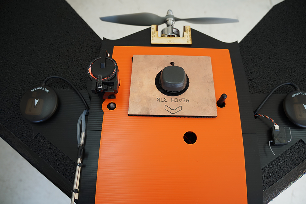
The key feature of the setup is use of Reach RTK and Tuffwing/Reach RTK hot shoe cable together connected to the camera’s hot shoe (Fig.2). This cable powers Reach rover, triggers camera from Pixhawk and directs flash sync pulses to Reach. Exact moment of each pulse is stored as time mark in the Reach RINEX files. No configuration for the Reach hot shoe cable is required, the camera will automatically trigger the hot shoe and the Reach will automatically record events down to fractions of a millisecond. This process does not require communication between autopilot and RTK receiver.
After the flight the time marks are converted into geotags with a free RTKLIB software provided by Emlid and are used for direct georeferencing of images. Commercial software such as Grafnav will be efficient as well.
To validate performance of the system Tuffwing organized flights using their Tuffwing UAV Mapper drone with Reach RTK GPS onboard. 112 photos were acquired with a Sony Nex 5T with Sony 16mm lens triggered by a Pixhawk.
Information about acquired data:
Altitude: 100m.
Average Ground Sampling Distance (GSD) 2.82 cm / 1.11
Area Covered 0.1139 km2 / 11.3916 ha / 0.044 sq. mi. / 28.1638 acres.
Comparative quality report prepared in Pix4D by Tuffwing was based on geotag file from Reach RTK and GCP-file for validating the accuracy of 3d map. It is showing that the RMS error for Y-direction is about 4 cm while X-direction is less than 3 cm. All the data with detailed manual for processing the report is available, you can find links in the end of the article.
Tuffwing is now working on documentation to show complete data processing workflow.
Yes, base station is required if you want to get high precision. The base station could be second Reach unit or other RTK receiver. Many countries have publically available base stations (CORS).
Thanks @dmitriy.ershov,
I download your dataset, so I can read EXIF from images (ISO : 800, Speed : 1/800, Opening : f/8). I suppose you block the objective in order to keep same camera adjustments for all the flight?
I also process it in Pix4D, I got better result (XY : 2-3cm, Z : 5cm) by processing initial step with scale : 1/4. Impressive results!!!
Did you correct the GNSS position with lever arm?
I set the camera to Manual mode. I always use f/8, 1/800 and control exposure with ISO. It was low light when I flew so I had to increase ISO to 800. There is nothing special about my settings, just what I like.
Better Pix4D results: maybe you have the magic touch when selecting the center of the target in the photo?
I did not account for antenna/camera offset. I mounted the antenna directly over the camera. The camera LCD screen is right below the antenna.
Hi @Brian_Christal, thanks for your answer.
For the camera, i’m asking if you block the focal because I know it’s very critical in direct georeferencing. If the focale is not the same for all images, the photogrammetry software can failed to compute Internal Orientation Parameter (IOP).
I’m actually working on a direct georeferencing solution by multi-copter UAV. My solution use a High precision GNSS receiver and the HotShoe cable, but she also have a gimball, so I have to transform the GNSS coordinates with the lever arm.
I’m not sure what “block the focal” is. I set the camera in manual mode and take pictures while the UAV is flying. There is no gimbal. The camera rides in the body of the airplane and is subject to the orientation of the airplane. Nothing with the camera or photos is modified.
I’m sorry, i didn’t use the good word.
When I adjust my camera, usually I use a “manual focus mode”. I adjust the focus, and then I block it physically with tape. With this, the focale length is not changing during flight. Do you understand me?
I got similar results with my Reach installed on a DJI P4, confirms that when you get FIX the Reach does deliver. The onboard logging and time signal capture in such a small package make it my PPK/RTK GNSS of choice!