Has anyone set up an Emlid Rover to connect to a local Tribmle base station that is outputting RTCM3 corrections via TCP? (Not via an ntrip server)
The Rover will connect to the same LAN that the corrections are being sent from.
The rover will have use the same satellite constellations as the Trimble base.
Can I simply set up the Emlid rover as a client and connect to the IP and port that the Trimble base station is sending RTCM3 out on?
I have set up an Emlid Base as a server before and connected to the Rover as the client using TCP and hope that it is as simple as this with the Trimble as the base.
If anyone can help me with this information I would be great full to you for the information.
That set up looks like it is suggestion that the Base and the Rover are EMLID.
I am wanting to use a Trimble Base with a Emlid Rover.
I am not sure if you can set up the Trimble base as a server. I think it could work if I can set up the Trimble base as a ntrip server, but this is not what I want to do if i can help it.
It would be great if it works the same as using Reach for the Base and the Rover.
Have you tried ?
Sometimes it is simply easier than one would think.
If the Trimble base can’t act as TCP server, you can always sent corrections to places like rtk2go and have the Emlid rover stream corrections from that NTRIP service.
I’ve tried to configure Trimble TrimTalk 450 Radio, but it works on quote:“TRIMTALK 450S radio modem operates in one of the following frequency bands: • 430-440 MHz • 440-450 MHz • 450-460 MHz”
and Emlid LoRa radio operates within 868/915 MHz.
Depends what model of Trimble you are using i suppose.
Correct, that Trimble is UHF. If you have a SS (spread spectrum) receiver rated at 915mhz you can put on a modem and use tcpip. At least with Topcon from what I have tested.
Working with some good techs at the customer’s site, we managed to get correction on the reach via the Trimble base over TCP.
In the end it was simple enough to do with the only issue being that we had a checkbox set on that is set as default to client on the base and not as a server. No idea why that would be default as a client on a base station, but anyway it is going.
I managed to get a fix solution on the rover, but it was jumping in and out of fix into float a lot.
In fact as I was time poor on the customers site, I dont think the base station had all the corrections for what I needed as a result I spent some time trying to figure out what they had On and what was not working on the Reach.
As I was able to prove that using the Reach to get a fix that was the aim of the day. We did not undertake any accuracy checks.
The customer operation is about 900kms East of Perth in Western Australia I know this as I had a Reach base set up in Perth as a back up and when I turned on the rover that I connected to a mobile hotspot, I got the distance from base reading on the Emlid interface. Anyway, why I am telling you this is a long time before GPS someone went out here and placed a peg in the ground and called it point A and said this is x=0m y=0m and z=? From there if you went due north by the compas your x increased and if you went east your z would increase in meters. So today they still use these x and y values and to get them into lat and long they need to use what is called a local grid off set.
To do this calculation I need a x y and a lat long from the same point and then convert these using a lot of calculations so that we can work with it.
Once done once we then apply this conversion to everything we do so that the Reach is reporting in x and y from the lat and long it receives. Hard to understand, yes, hard to work it out the first time, yes, once it is done, it is easy enough to implement and maintain for this site.
So thank you to all that helped me with my question, Can a Trimble GPS Base station output corrections to EMLID without too many issues. The answer is YES it can. At the same time it can output the CMR services it uses between other Trimble equipment.
Congrats on your success! Perhaps you could put together a comprehensive guide on how you did it? Also, you could probably make you life allot easier for the site conversions if you used QGIS. You can bring in the lat/lon data and convert it on the fly to any epsg you like. This instantly gives you the the x,y values for those points.
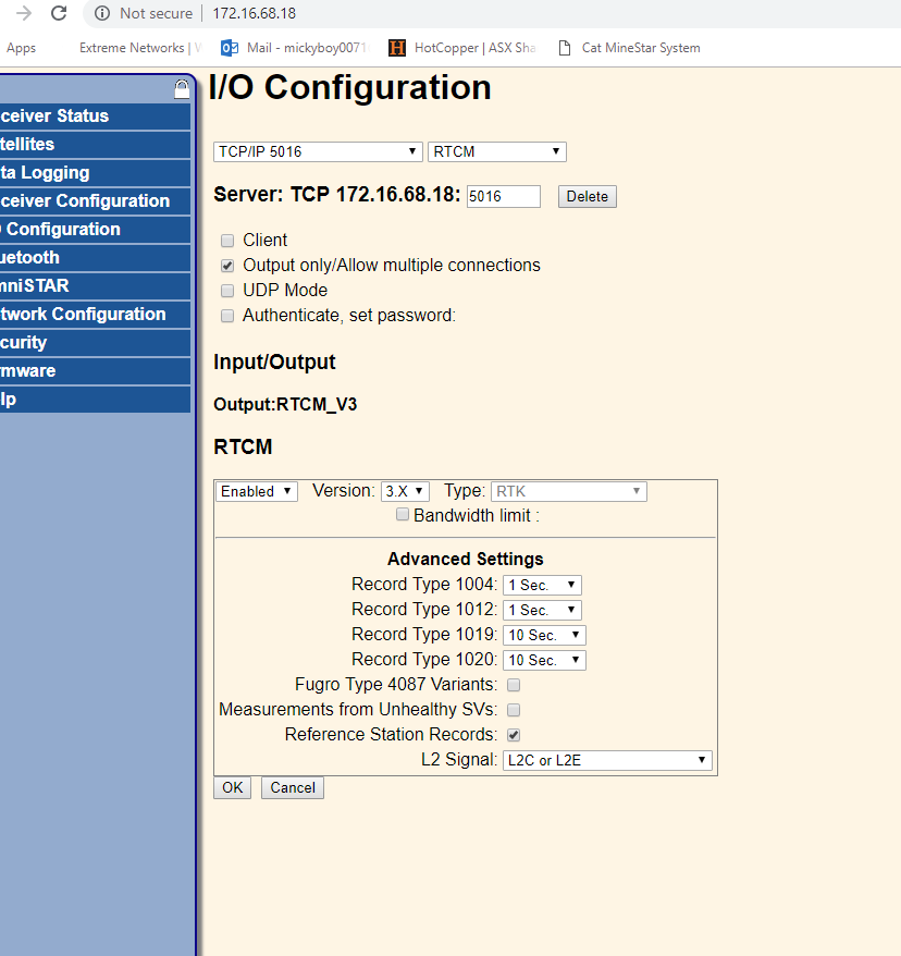
Here is the settings we got to on the Trimble base, as you can see in the advance settings, you only get to select messages 1004, 1012 that include L1 and L2. The Trimble base is receiving the other types of satellites, but it seems that Trimble is not making them available to users of RTCM3.
If anyone else can confirm this I would be grateful as I need these for my location in the world.